 Web
and Book design,
Web
and Book design, Copyright, Kellscraft Studio 1999-2007 (Return to Web Text-ures) |
Click
Here to return to Sand Dunes and Salt Marshes Content Page Return to the Previous Chapter |
 (HOME) |
|
CHAPTER IX SALT MARSHES — THEIR PAST AND FUTURE
IN a study
of the
past it is convenient to have some definite point from which to date.
To the
original settlers on these shores Noah’s flood
was a very real catastrophe, in which everything on the earth was
washed clean,
and, by a reference to the Bibles of those days, or even to the Bibles
of fifty
years ago, one may learn that this flood occurred 2,349 years before
Christ. To
our forefathers the time that had elapsed since the flood was a long
period to
contemplate, but nowadays we are contented to look upon the fifty
thousand
years more or less, since the last glacier left these shores, as a mere
moment
of time in the great past. There is no doubt that the glaciers compared
favorably with Noah’s flood in cleansing power. Everything of an animal
and
vegetable nature has come in since then, including the salt marshes
themselves,
which are made up of various growing grasses on top, and, in their
entire
thickness of closely woven sod and thick black soil, they are largely
of
vegetable origin. One must picture this region at the close of the
glacial
period, therefore, as entirely destitute of the most striking feature
of
to-day, a region of brown land and blue water, but lacking the great
blanket of
green marsh. As one looks inland from the Ipswich dunes over the broad plain of salt marshes, the rounded form of Hog Island — the birthplace of Rufus Choate — looms up as a conspicuous object in the landscape. It is a typical drumlin, one whose duplicates are to be found everywhere in northern Europe and America, where the ice sheet of the last glacial period formerly held sway. It is a smoothly rounded accumulation of turf-covered gravel a hundred and forty feet high, somewhat steeper on the north than on the south side, but as featureless as an inverted punch-bowl. On the western side its curves are cut by the flat plane of the salt marsh. Scattered here and there in the marsh are to be seen lower rounded or oval islands, some of them covered with trees, while in the Castle Neck River is a small circular gravel island so low that it is all but overtopped at high tide. Aside from
the thin
coating of soil and vegetation, Hog Island shows scarcely any
evidence of
change by wind, water or frost that have been acting on it since it
emerged
from the glacier’s bed. We are indeed very close to the glacial period,
and the
interest in arctic life and adventure, an interest which is common
among
northern people, and extends even to the delicate of both sexes, is,
perhaps,
an inheritance from the times when glaciers spread far down among the
homes of
our ancestors.
Shaler in
writing
from Florida said: “The nearer I get to the tropics the more I turn
with
pleasure to our grim northern clime.” It is well
that
this love of the ice, which is often incomprehensible to those of
southern
ancestry, continues to exist, for who can say but that the glaciers of
Greenland and Alaska and Spitzbergen, of the Alps and the Himalayas
may not
again wax and spread over regions now in the temperate zone? May it not
be that
the present is merely one of the interglacial periods which have
occurred again
and again during the ice age? Indeed, there is reason to believe that
some of
the interglacial periods of the past were even longer than the
interval of
time which has elapsed since the ice receded. In order
to picture
the land as exposed by the receding glacier, we must not only strip off
the
salt marsh, as well as all other evidences of vegetable and animal
life, but we
must do more than this, for, as we shall see, there is every evidence
of a
former higher elevation of the land in relation to the water. There are
also
reasons for believing that as the land sinks, the marsh, soft and
uncertain as
it seems, is really more stable than the everlasting hills, and
maintains
itself at the same point. Some of
the low oak
islands in the marsh are doubtless the tops of drumlins or of smaller
glacial
hillocks, as is shown by their circular or oval outlines and gravelly
formation,
while the round pebbly island in the Castle Neck River is of the same
nature,
but is now so nearly submerged, that all humus and land vegetation, as
well as
the finer particles of the top of the gravel hill, have been washed
away in
stormy tides, and nothing but boulders and sand is left. If the
land had
remained at the same level as it was at the close of the glacial
period, we
should be able to discover some traces of ancient shore line where the
sea
waves formerly pounded, some old beaches with sub-fossil shells and
crabs on
and under the borders of the marshes, separated now from the sea by
acres of
green salt turf and by barrier sand dunes, which, like the marshes, are
of
recent formation. If on the other hand the land had risen at various
rates, we
should find a series of flat terraces or several elevated beaches, as
on the
Labrador coast to-day, where one sees two or even three beaches one
above the
other, some of them two hundred feet or more above the present sea
level and
almost as clean as when the surf beat on them. In this Ipswich region,
however,
there are no traces of old terraces or beaches, either at high tide
level or
above. Hence the land could not have been stationary or rising. One
alternative
alone remains, namely that the land has been slowly sinking, a process
in which
all landmarks are covered up or “drowned.” Of course the same results
would
obtain if, instead of the sinking of the land, there had been a rising
of the
water, and the theory is held by some that the amount of water in the
ocean was
tremendously increased by the melting of the glaciers during their
recession.
It hardly seems possible that this would account for the difference in
level
which seems to have taken place during the last thousand years or so,
at the
same time that an opposite change has been taking place in Labrador. Be
that as
it may, if one stands at the top of Hog Island at high tide at the full
of the moon,
and looks out over the waste of waters extending several miles inland,
flooding all the marshy valleys and making veritable islands of the
drum-
lins, one is impressed with the force and accuracy of this term drowned. 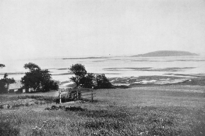 THE MARSHES AND HOG ISLAND, HIGH TIDE At a
number of
places along the coast of Essex County the evidence of the changing
level of
the land is shown so plainly that he who runs or even swims may read,
for there
are stumps of forest trees still in position in leaf-mould and peat
beds below
the level of high water. In a cove near Bass Point at Nahant the stumps
of
white pine and white cedar, hemlock, spruces, ash, oak and maple are to
be seen
covered by thirteen to sixteen feet of water at high tide. In Lynn
Harbor, and
in the Saugus marshes, at Swampscott, Marblehead, Manchester and in
Salem Harbor,
these remains of submerged forests are also found, while near Misery
Island,
when the tide is low and the
water still, stumps of forest trees may be seen at
a depth of twelve to fourteen feet. In a marsh at Ipswich that is
flooded by
the great tides of the full moon of spring and fall, several stumps of
great
trees are to be seen imbedded in the salty peat. One of the old farmers
told me
that when he was a boy an old man used to say that his father
remembered when
this region, now filled by the black-grass marsh, was occupied by a
grove of
forest trees. Professor E. C. Jeffrey very kindly examined chips from
two of
these stumps for me, and found that one was a white pine, and the other
a swamp
white oak. In 1804
and 1805
Dr. Nathaniel Bowditch prepared a chart of Salem and Marblehead
harbors, giving
the soundings over various ledges and rocks. Ninety years later, in
1894,
careful measurements were again made at these same points and under
similar
conditions of tide and moon, by the late Professor John H. Sears. In
all cases
the water was found to be from one to two feet deeper than it was
ninety years
before. In 1903 Mr. John R. Freeman concluded that the land in Boston
and
vicinity was sinking at the rate of a foot in a hundred years by
comparison
with various ancient and modern tide gauges; also by the fact that the
sills
and floors of the masonry dry dock at the Charlestown Navy Yard then
stood
about nine inches lower relatively to mean sea level than they did
seventy
years before, while the dock stood at precisely the same level
relatively to
points on solid ground. An
incontestable
evidence of a former higher land level is presented by the deep
channels of all
our eastern rivers, up which the tide rushes for many miles, and by the
fact
that these channels extend for a long distance out to seaward under the
water.
Only when the land stood at a much higher level could these channels
have been
cut. Another
strong
evidence of subsidence is shown in a study of the sections of the
marshes, for,
as we have seen, the various species of grasses are limited to certain
zones in
relation to the tides. As remains of grasses are found in the sod
sections
several feet below the level at which they can now grow, the inference
is plain
that portions of the marsh formerly stood higher in relation to the
tides.
Professor Charles A. Davis has made a careful study of the marshes
about Boston
by means of borings, and he has found even at a depth of twelve feet
below the
surface of the marsh, peat that was composed of the grasses now growing
on the
surface. It must be
remembered, however, that the height of the tides is dependent very
much on the
character of the shore line, as Professor D. W. Johnson has shown, and
as this
changes from time to time independently of changes of land level,
regions not
previously flooded may suddenly be drowned by high tides. This
fictitious
appearance of coastal subsidence, however, need not blind our eyes to
the many
incontestable evidences of true subsidence which cannot be so
explained. As an
example of
the possibility of erroneous interpretation of marsh deposits, the case
of a
similar seashore region, that of the North River valley at Scituate is
instructive. Here for many years prior to 1898 the mouth of the river
bed had
been so silted up that the tides were practically excluded — and the
level of
the marsh, which supported a fresh water vegetation, came to be, as
subsidence
continued, several feet below the level of high tide on the outer
beach. In the
great November storm of 1898 the sea broke through the barrier beach
some
distance from the mouth of the river, and since then the tide has ebbed
and
flowed freely in the valley, drowning out the fresh water vegetation
and
killing grass, bushes and trees. The marsh of a salt water formation is
gradually building up to the high tide level. Suppose, then, that in
the course
of centuries this new mouth should become silted up, the influx of salt
water
excluded as before, the marsh would again take on a fresh water
character. If
these changes were repeated several times a section would show
alternations of
fresh and salt water deposits. The unwary geologist might infer, and
his
inference would be extremely plausible, that there had been times of
alternate
elevation and subsidence of the land, whereas in reality there had been
all the
time a subsidence. The
evidence of the
sinking of the land seems to me plain, but why is not the salt marsh
drowned
too, or rather why is there any salt marsh formed at all? As the land
sinks and
the water rises it would be easy to picture the gradual extension of
the sea
into the land, the waves lapping the shore, all the time reaching
higher and
higher, until even the old glacial hills were overflowed. This would
certainly
be the condition of things if the marsh did not build up as fast as the
land
sank, and the upbuilding can be seen in all the zones of the marsh. Everywhere
in the
creeks and estuaries, shut out by the sand dunes from the impact of the
waves
of the sea, forests of waving eel-grass flourish and entangle the fine
sediments in their meshes, and help build up this zone. When the sand
brought
in by the tides and storms has accumulated in shallows so that these
flats are
sufficiently exposed at low water, the thatch grass claims it, and
entraps the
finest mud among its stalks. Into this the grass from its hollow stems
sends
out higher and higher roots, and the whole becomes compacted into a
loose sod
of mud, stems and roots, a soft, muddy, peaty mass. Thus, though the
very
foundation of things is sinking, the bottom does not drop out, and the
depression is so gradual that the grass easily keeps pace with it. 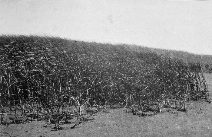 THATCH GRASS BUILDING OUT ON THE EDDY SIDE OF A CREEK  THE BANK FALLING AWAY ON THE CHANNEL SIDE OF A CREEK As the
tide sweeps
alternately up and down the estuaries twice a day each way, it bounds
back and
forth from side to side with great symmetry of rhythm, eating away one
bank by
its swift current, while the opposite bank extends itself outward in
comparatively calm water or in counter eddies, and here it is that the
thatch
grass flourishes. Another place where one can watch the extension of
the
thatch, the pioneer in this great march of the marshes, so to speak, is
on the
large sand flats gradually building up in regions of comparative calm
outside
of the full swing of the tides. On one such flat in the Castle. Neck
River
there are now nine thatch islands from two to twenty-five feet long,
besides
five small single tufts of grass, and none were to be seen there twenty
years
ago. In another place a large thatch island a hundred yards long and
half as wide
has appeared and grown within the memory of one of my farmer neighbors
in the
last sixty years. A shift in the currents may in a short time wash away
this
work of years, and may even enlarge some of the creeks, but I am
inclined to
think that the general tendency is toward a contraction of the tidal
estuaries
by the enterprising thatch. The third
zone,
that of the marsh hay, which constitutes the greater part of the broad
marsh,
is in the same way able to keep its level in relation to the water by
the gradual
deposition during high tides of fine mud and sand, and by the climbing
up of
the grass on the shoulders of its dead ancestors. In the swirl of the
tides the
sand and mud are constantly carried up from the sea, and while the
sand holds
its place in tolerably swift water, the mud comes to rest only in
regions of
comparative calm. Both are dropped in periods of quiet water between
tides. The
fresh water detritus brought down by the rivers here is so small in
amount that
it plays but an insignificant part in the building up of the marshes. In calm
weather a
surprising amount of sand is borne along by the rising tide, floating
on the
surface in the same way that a needle can be floated in a tumbler of
water. The
slightest touch of a grass blade or a cat’s paw of wind sends the sand
to the
bottom. In winter, ice cakes, with mud and sand frozen into their lower
surfaces, or bearing loads broken away from the banks, are often
stranded far
afield by the high winter tides, and, in melting, materially help in
the
building up of the marsh. A certain amount of sand is blown inland over
the
marshes from the dunes. 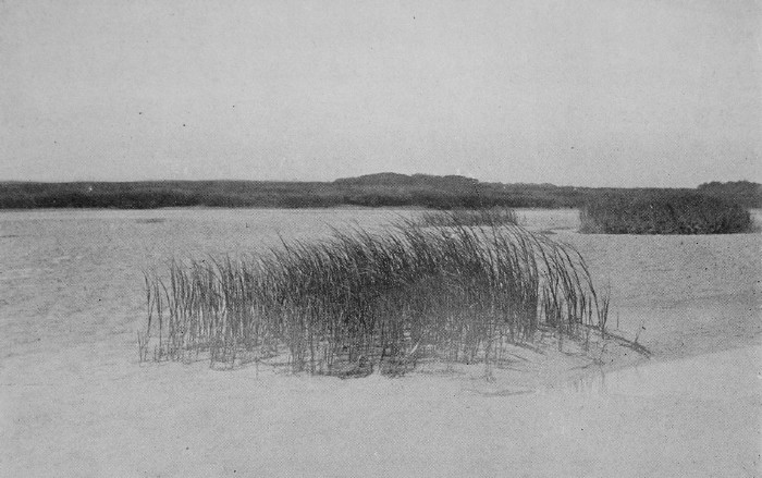 ISLANDS OF THATCH AT LOW TIDE 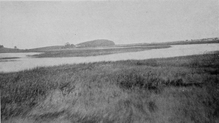 MARSH AND CREEK AT HIGH TIDE The fourth
zone of
vegetation, the zone of the black grass, which fringes the whole
region, is
visited only by the exceptionally high tides, and very, very slowly
creeps up
on the fresh water land, displacing the life there, be it fragile herbs
or
mighty forest trees. All yield before the strength of the salt sea. It
has been
found that one and a half per cent. of common salt in the soil is
poisonous to
plants that do not naturally grow on the seashore, while sea water
contains
two and a half per cent., and the soil of salt marshes, on which all
these
halophytes, or salt-loving plants, grow, may contain even more
salt. In other
words, the
vegetation of all the zones holds its own, and in places more than
holds its
own against the advancing sea. A slight increase in the rate of
subsidence
might reverse this, and the sea would drown the grass, and great inland
bays of
sea water would replace the marshes. With a cessation in subsidence,
the
estuaries would become more contracted, and the fresh water vegetation
would
very gradually creep down upon the marsh. A change to a movement of
elevation
and the salt marshes would in the course of time cease to exist. Accurate
maps of
the marshes made from time to time, even in the brief space of the
white man’s
occupancy, — less than three centuries, — would be of great value in
showing
the changes that have taken place, but such maps are lacking. In
England, however,
history goes farther back, and there is plenty of evidence that the
marsh
lands of East Anglia, the region of the Norfolk Broads, which
corresponds in
many ways with this Ipswich region, have become less and less invaded
by the
sea, notwithstanding the subsidence which is going on there as here. When the
Romans
devastated the country, they sailed far up the great tidal estuaries,
which are
now narrow sluggish streams meandering through meadows of fresh grass,
and
attacked the ancient Britons in the highlands at Reedham and Norwich,
now
eighteen miles from the sea, and here they “buylded toures on the dynes
of the
ocean in dyverse places.” One may read in the Saxon Chronicle that in
the year
1004, Sweyn with thirty ships plundered and burned Norwich. Even as
late as
1327 it is stated that Norwich is “situate on the bank of a water and
arm of
the sea, upon which ships, boats and other vessels have immemorially
come to
their market.” Accumulations
of
silt and the growth of vegetation, narrowing these estuaries into
sluggish
streams, with here and there dwindling sheets of shallow water called
broads,
can be explained by the cutting off of the sea and tidal currents owing
to the
formation of sand-bars and later of dunes at the mouths of the rivers.
The most
famous of these sandbars is the one on which the fishing town of Great
Yarmouth now stands. Even before the Norman Conquest the sand-bar at
this point
had become a sand bank frequented by fishermen. Later man cooperated
with the
ocean by building dykes and drains and erecting wind and steam
pump-mills
still more to exclude the salt water, and hasten the deposition of mud
and sand
and the building up of vegetation. That
subsidence is
still going on, however, is evident from the fact that parts of the
Broadlands
are below the level of high tides, protected from the ocean by only a
narrow
strip of sand dunes. In places the sea is gradually gaining on the
sand, so
that the ruined church of Eccles, found by Lyell half buried in the
dunes in
1839, has since been entirely destroyed by the waves, and it is feared
that the
sea will finally conquer and flood the sunken land. From these
same
Norfolk marshes nearly three hundred years ago came to the Essex
marshes in the
new world many of the ancestors of the present inhabitants. It is
pleasant to
fancy that the love possessed by some of us for salt marshes may be
inherited
from our English forebears, who long years ago hunted and fished in the
marshes
and tidal estuaries of old Norfolk. One can
see in the
mind’s eye the recession of the glaciers, the bare gravelly hills and
the
numerous streams coursing over the sandy boulder-strewn plains high
above the
sea, which was then many miles to the eastward; the coming of plant and
animal
life, including that of man himself; the cutting down of the streams,
the slow
gain of the sea on the land as the latter sank, and its extension in
the form
of estuaries into the river valleys; the piling up of the barrier sand
reefs
and later of the dunes, and the extension and building up of the salt
marshes,
keeping pace with this depression, and their gradual march to the
westward as
the sea gained on the land. Shaler
said of the
salt marshes: “The remote and picturesque coral reefs have long proved
fascinating subjects to the geological student, while these
near-at-home
structures, which are in their way almost as interesting as the work of
the
polyps, have never been adequately studied.” Those who
decry the
study of science as dry, and advocate the reading of fairy stories and
romances
only for the cultivation of the imagination, are evidently totally
unaware of
the pleasures and possibilities of geology. The
question is
often asked whether these marsh drumlins, now covered only with grass
sod, were
ever forested, and we are fortunate in possessing an early description
of this
region by Captain John Smith, who landed at Agawam, the Indian name for
Ipswich, in the year 1614. He says: “This place might content a right
curious
judgment; but there are many sands at the entrance of the Harbour, and
the
worst is, it is imbayed too fayre from the deepe sea. Here are many
rising
hills, and on their tops and descents are many corne fields, and
delightfull
groves. On the East is an Isle of two or three leagues in length; the
one half
plain Marish ground, fit for pasture, or salt ponds, with many faire
high
groves of mulberry trees and gardens. There is also Okes, Pines,
Walnuts and
other wood to make this place an excellant habitation, being a good
and safe
harbour.” The Indians were in the habit of clearing the ground by
burning, and
to this is due the openings for their corn-fields and gardens. It was
indeed a
favored region, a happy hunting ground, and the Indians lived here in
comparative peace and plenty before the white man came with his
devastating
diseases, his fire-water and fire-arms, and his corrupting morals. On
the
drumlins and in the dunes are many evidences of the departed race, —
ancient
shell heaps of clams and oysters, — for oysters formerly throve here,
and,
intermingled with them, bones of the great auk, of ducks and waders
and
turkeys, of deer and bears and seals. Arrow-heads, sinkers, stone axes
and skin
scrapers, and bits of rude pottery are still to be found in the shell
heaps
and in the fields round about. 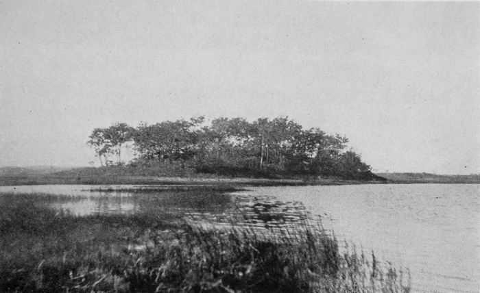 A MARSH ISLAND 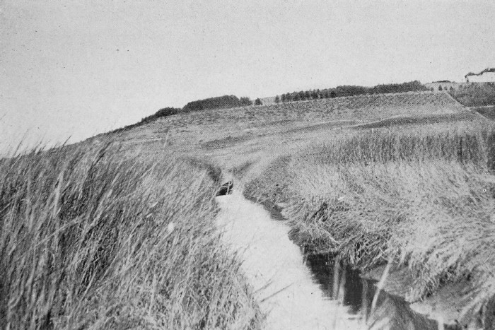 THE OLD CANAL. Another
record
pointing to the forested condition of the drumlins is an ancient law
passed in
1650, whereby the felling of timber on Jeffrey’s Neck, Castle Neck and
Hog Island
was prohibited, although we learn that in 1670 all fishermen were
allowed to
cut wood there for house building and fuel. In 1726 a deed of sale was
executed
for “wood that now is, or that shall hereafter be standing, lying or
growing on
any part of Castle Neck so called beyond Wigwam Hill.” Although
the larger
drumlins, like Hog Island and Jeffrey’s Neck, are now nearly bare,
except for
the willow trees planted to shelter cattle, the smaller islands are
covered
with trees and bushes and are spots of much interest to the botanist.
Red oaks
are the common trees, but white birches, poplars and hickories also
occur, as
well as a few swamp white oaks, canoe birches, sassafras and lindens,
and on
one island a few red pines and on another a grove of white and pitch
pines.
Dog’s-tooth violets, oak-leaf gerardias, hepaticas and feverwort are
also to be
found on these islands. Oak Island in the Lynn marshes has been
studied for
years, and nearly four hundred different kinds of plants have been
found
there. It would seem as if the plants had gathered from all sides to
avoid the
rising tide of the salt marsh! The
meadows but
lately reclaimed by the slow process of nature from lakes and ponds,
the
recently formed salt marshes and the sand dunes last thrown up by the
sea, were
then as now destitute of forests. One can easily discover by a simple
experiment
that in as short a time as ten years a sod-covered upland will return
to an
incipient forested condition, provided three destroyers — fire, the
cutting
tools of man, and the teeth of browsing cattle are excluded. Wild
roses and
blackberry brambles first spring up in the grass, and bayberries,
hardhack and
barberries soon follow. The more cover these give for the birds to
nest and
roost in, the more seeds are dropped there by these natural forest
planters,
and sumachs, thorns, rum cherries, apples, maples and red cedars soon
appear. So much
for the
marsh and its prominent features, and so much for its past history. How
about
its future? As Hog Island is a hundred and forty feet high, one can
easily
calculate that if subsidence
continues to take place at the rate of a foot a
century, and if the sand
dunes continue to pile up and shut out the sea, so
that the marsh may build up at the same rate, it will take fourteen
thousand
years before Hog Island disappears below the mantle of green marsh,
which at
the present time has almost surpassed the pebbly island of the Castle
Neck
River.1 What manner of man will there be to see, and echo
answers
what indeed? Fourteen million years from now, the marsh, after long and deep burial under heavy loads of sediment and possibly of glacial till and of lava floods, may perchance be lifted up and emerge to the light of day from an eroded mountain side as a sandy coal-seam. Imagination refuses even to consider the condition of the human race at this remote period!
_____________________
1 It is probable that if
the coast
continues to sink the barrier dunes Will move inland, so that instead
of Hog
Island being overwhelmed by the marsh it Will be battered by the sea
in the
same Way that Great Boar’s Head is now battered, and that it Will
finally
succumb to the assaults. |
 Click the book image to turn
to the next Chapter.
Click the book image to turn
to the next Chapter.