
Web
and Book
design,
Copyright, Kellscraft Studio 1999-2007
|
Sand Dunes and Salt Marshes Content Page |
 (HOME) |
|
Sand Dunes and Salt
Marshes CHAPTER I SAND DUNES
SAND dunes
have a
fascination all their own. In the multiplicity of their forms and
colors,
varying with the seasons and years,
they are a
constant source of pleasure, while in their wealth of plant and animal
life
their interest is never-ending. The beauty of the sand dunes is
revealed at
every turn, their secrets are legion. The course of their formation
from the
time they emerge out of the sea as reefs washed by every tide, until
they have
reached perfection in their wave-like crests fifty feet high is an
absorbing
study. Their surface records a continually changing story, —
ripple-marks of
the varying winds, magic circles made by the grass, and myriad tracks
of living
creatures. A day spent in the dunes
with the roar of the waves and the cries of the gulls in one’s ears, the breath of the marsh and of the ocean in one’s nostrils, the wild beauty and loneliness of the scene in one’s eyes, is indeed an inspiration, a memory worth treasuring.
The reefs along the beach are constantly changing. One of these I have watched and recorded since 1892. When first seen, it was already above high tide except at its northwest extremity, and connected with the beach off the Ipswich range-light. Like other reefs, its slope was gradual on the seaward, steep on the landward side, and so narrow that I used — in those barbaric days — to build my blind in the middle of the spit and shoot over decoys placed at the water’s edge on both sides. 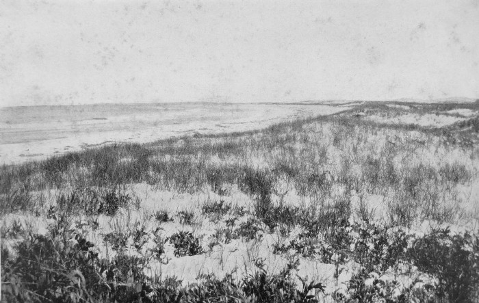 THE BEACH AND THE SEA FROM THE DUNES As the sea
threw up
more and more sand, and the wind seized it and blew it inland, the spit
extended and broadened and cut off a lagoon of several acres in extent,
so
protected from the sea waves that a different marine life flourished
there. It
was a godsend to the old lighthouse-keeper, for he could dig at his
door all
the clams he needed without having to wend his way to the inland
creeks. This
was the only place on the outer side of the dunes where common clams
were
found, for on the unprotected beaches the massive sea-clam, an entirely
different species, alone flourishes. The spit grew year by year, and
in 1904
had become an elevated plain three hundred yards broad, which
completely
enclosed the shrunken lagoon, now brackish and stagnant. The clams had
all
died and another set of inhabitants flourished there, dominated by
great masses
of slimy algae. But the sands kept blowing, and in 1906 the pool was
entirely
effaced. Clumps of beach grass appeared in places, and the sand
collected about
them and formed the beginning of dunes. Later,
owing to
some change in the currents along the shore, the waves demolished their
own
handiwork, and in 1908 veritable sub-fossils, the shells of the common
clam,
began to appear on the outside beach, standing in place with their
empty valves
pointing upward as in life. While clumps of beach grass are often responsible for the birth of a dune as just described, any obstacle or irregularity, in whose lee the heavier grains of sand settle, may also start a dune on its progress. However started, their forms are many and various, yet, as they are all dependent on the winds, they are shaped by the strongest or dominant ones, and these are the winds which blow from the northwest, north and northeast, during the winter months. Certain secondary or transient modifications are due to other winds, particularly to the prevailing southwest breezes of summer, but a visit to the dunes in a snow-spitting northeaster of winter gives one an idea of aeolian power not often realized in the gentler summer season.  THE LIGHTHOUSE IN THE SEA OF DUNES Smiling
skies,
gentle balmy breezes, flowers blooming and filling the air with their
perfume,
bird songs ringing from every clump of bushes and grove of trees,
perfect gems
of color in a setting of brilliant white sand, — all of these are
seductively
enchanting. But the full glory of the dunes, to my mind, is to be found
in the
winter storms, when the biting wind sweeps with resistless force over
them,
driving snow and sand into the face of the toiling dune traveller, when
the
gulls scream noisily overhead, and flocks of ducks, restless in the
foaming
seas, scud by before the blasts, while over all the roar of the waves,
pounding
relentlessly on the beach, sounds a grand sea dirge. As one pauses for
breath
in the lee of a dune and watches the clouds rush by over the tumultuous
ocean
of sand, one feels to the full the primeval grandeur of the dunes and
sees them
in their true colors and stormy activities. Ripple-marks
form
on the surface of the sand whenever it is dry and the wind blows. These
are
parallel ridges athwart the wind, with steep sides to leeward,
gradually
sloping ones to windward. Similar ripple-marks are left by the receding
waves
on the beach, or by the sweep of the tides in the estuaries, or by the
rush of
the brook to the sea. In the estuary the steep side of the ripple-mark
is
up-stream on the flood and down-stream on the ebb tide. In the bed of
both
water and wind stream the grains of sand are pushed along in parallel
ridges up
a gradual slope until they drop over and come to rest on the steep
sheltered
side. In a
gentle wind
the ripple-marks advance so slowly that one is unconscious of any
change, but
in stronger blasts the changes are very manifest. On a blustering March
day
with a keen wind from the northwest I watched some ripple-marks that
were four
inches apart from crest to crest, and found that they were advancing at
the
rate of a foot in eight and a half minutes. The most common form of dune at Ipswich is one whose longest axis runs from east to west across the prevailing winds, and these again may be divided into two classes. Both advance to the south like waves before the boreal blasts, but the commoner, unlike the water wave, presents its crest to the storm and retreats backward. The sharp, steep side of the dune is undercut and worn away by the wind, and streams out on the sweeping slope to leeward. Owing to the multitude of interlacing rootstocks and rootlets of the beach grass the crest sometimes overhangs like a breaking wave, and masses of roots and sand fall from time to time as the wind undercuts them. Indeed, this slope of the dune, the reverse of the normal one about to be described, is, I believe, due entirely to these beach grass roots — bricks made with straw. 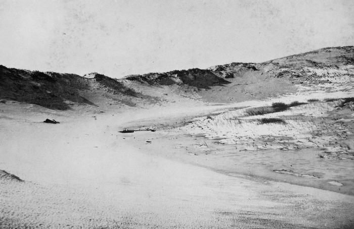 A SMALL AMPHITHEATER IN THE DUNES These
reversed
waves of sand reach their fullest development at the southern end of
the
Ipswich dunes, where they form a series of parallel ridges, with their
steep
sides facing the north. They have advanced southward in the middle more
than at
either end, so that they describe the arcs of circles, and resemble a
series of
gigantic amphitheatres. One wave that I measured in 1903 could easily
be traced
for some 1,350 paces, or three-quarters of a mile, and it stretched
from the
estuary on the inside to the sea on the outside. Its breadth varied
from forty
to two hundred yards, and its height from twenty to fifty feet. The
distance
between the waves varies from a hundred yards to a quarter or half a
mile. The
highest points
or peaks of the dunes often show long ridges of sand extending in the
wind’s
axis to leeward of them, and these longitudinal dunes are sometimes
found by
themselves, and constitute a distinct type, although not often
developed to a
great size at Ipswich. They are prone to form near the beach and appear
to be
indicative of unusually strong winds. Every now
and then
in the amphitheatre waves there are cross valleys with steep windswept
walls.
In the cuttings and on the sharp northward faces the stratifications in
the
sand are often marked, and the firmly packed layers stand out
prominently,
while the loosely formed ones are cut away. The strata often dip gently
towards
the south, for the sand is left by the wind on the southern or leeward
slope,
but they vary greatly and are irregularly superimposed. The angle of
the northern
slope of these dunes varies from thirty to ninety degrees, while that
of the
southern slope is about twelve degrees. The other
kind of
transverse dune — the normal desert one — although rare at Ipswich,
appears to
form only where the wind is unhampered by the binding grass, and is
one that
resembles more closely a wave of the sea, for its steep crest is borne
in
front, while the long, sweeping side is left behind or to windward. In
these
respects it is but the magnification of the ripple-marks on the
surface. 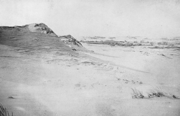 DUNES SHOWING WIND STRATIFICATIONS AND STEEP WINDWARD FACES There are
at the
present time two very striking examples of this form of dune at
Ipswich, one
of which, like a devastating tidal wave, is overwhelming the
southernmost of
the pitch-pine woods, while the other, nearer the mouth of the Essex
River, is
burying in its progress a grove of white birches. Both of these are
unprotected
on the north for a considerable distance either by bushes or by grass,
and
Boreas rushes over them unimpeded. The northerly slope is hard and
firmly
packed, and extends gently upward at an average angle of nine degrees,
whereas
on the south the sand, freed from the mighty power, settles softly at
an angle
of rest generally as steep as thirty-two degrees. Here it is so loosely
compacted that one may easily sink half-way to the knees. Both of
these dunes
have crests higher than their victims, the trees. The pine grove has
been so
far imbedded that the remains of the buried trees are beginning to
reappear on
the northern side of the dune. The exposed wood is decayed and soft,
but masses
of hard pitch can be found here and there on the bark, so thoroughly
infiltrated with sand that they look like sandstone or pieces of coral.
The rate
at which
the dunes advance varies greatly, but it depends chiefly on the season
of the
year. One of the fastest dunes is undoubtedly the large one just
mentioned
that is breaking over the birch grove, for here at the southern end of
the
dunes the sand is exposed to the full sweep of the north winds, and the
region
is widely destitute of grass or bushes. By means of marked trees I have
been
able to obtain exact measurements of the progress of the dune from time
to
time, for the edge of the sand as it advances into the grove is sharply
defined. In the five winter months, from December 5, 1909, to May 15, 1910, the dune advanced 87 1/2 inches, or about 17 inches a month, while in a little over five summer months, from May 15 to October 23, 1910, it advanced only 61 inches, or about 12 inches a month. The next winter was a favorable one for dune movement, for in the four and a third months, from October 23, 1910, to March 5, 1911, the dune advanced 256 inches, or at the rate of about 60 inches a month. The pine-grove dune advanced only 3 inches in the summer of 1910 from May 15 to November 6, but in the stormy weeks between the latter date and March 5, 1911, it advanced 71 inches. 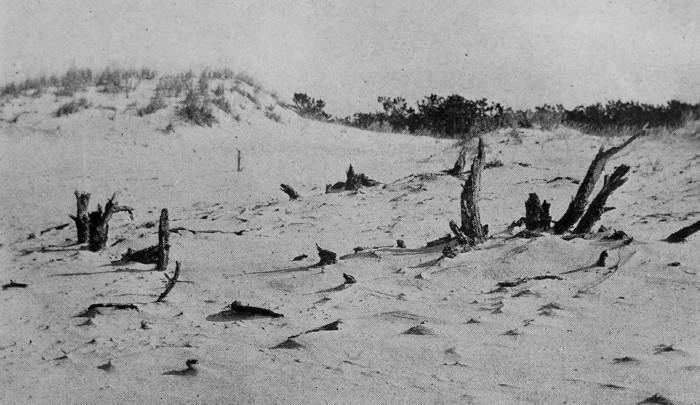 PITCH PINES AFTER THE DUNE HAS PASSED 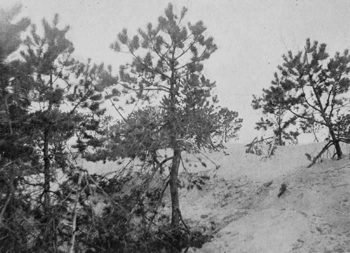 PINES OVERWHELMED BY THE ADVANCING DUNE On January
29,
1911, the signal stake placed by the Coast and Geodetic Survey on a
high dune
near the beach was 175 inches due south from the retreating northerly
face of
the dune. After four windy months, on May 28, the stake was only 132
inches
from the edge,-43 inches had been cut away. In a
recent book on
the Sahara, Hanns Vischer describes similar dunes, but on a much larger
scale.
He says: “Gradually these dunes are piled up and form ridge after
ridge, some
of them over four hundred feet high. These rise from the north in soft
curves
to fall off on the other side like a mighty wave. The ceaseless wind,
mostly
from the northeast, moves the sand along the surface, continually
changing
the position and formation of these banks.” His photographs show dunes
entirely
devoid of binding vegetation, with camels walking on the hard windward
surface,
but sinking deeply into the steep leeward sides. The “amphitheatre”
dunes so
common at Ipswich, with the steep side to windward do not occur
there, owing
to the absence of binding vegetation. Where the
winds are
irregular, as under the brow of Castle Hill, the dunes are often
circular and
cut out on all sides. Some have flat tops and stand out like miniature
buttes,
showing sections of nearly horizontal strata on all sides, while others
are
peaked or pyramidal in shape, and the circular scour of the winds
gradually
reduces their height without changing their shape. The sand
dune on
the edge of the beach shown here — the frontispiece of the “Birds of
Essex
County” — was photographed in 1900, but by 1907 it had been entirely
effaced. I
always called this Eagle Dune, as I had watched a bald eagle perched on
its
summit, but there is a tradition that it long bore the name of “the
headless
sailor,” for human remains of this description had been found washed
up at its
base many years before. In places
there are
pits in the sand which are so continually scoured by the wind that they
remain
open, and while they fill up on the windward side, they are cleaned out
on the
leeward and slowly move down wind. 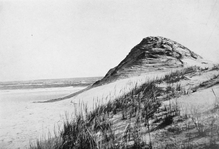 ON THE EDGE OF THE BEACH In a
strong wind
the peaks and crests of all the dunes smoke like so many chimneys, and
a cloud
of sand streams off, building the dune up to leeward. As Vaughan
Cornish has
suggested, a great mountain may be laid low by the slow process of
denudation,
while a humble sand dune still remains, for the process which denudes
it at
the same time renews it. The sand
blown from
the dunes on windy days cuts with stinging force, and one must guard
the
binoculars, for glass is quickly ground as by a sand blast. A clouded
condition
of the glass is shown on exposed windowpanes in the dune camps, or on
bottles
or any piece of glass lying on the sand. A large flint spear-head, I
found in
the dunes, has been so smoothed that the sharp angles of fracture are
effaced.
Pieces of wood are in the same way ground down by the sand blast and
take on
curious shapes determined by the position of the harder knots. The grains
of sand
which compose the dunes vary very much in color according to their
composition,
but at Ipswich the color of the dry sand is brilliant gray or white,
although
it may appear purple in the shadows or pink or gold in the sunset
light. The
winds have a selective power, and streaks and windrows of purple and
garnet or
even of black sands are often to be found. Under the microscope the
grains
appear like gems, and are seen to be more or less rounded and worn by
the
constant action to which they are subjected by the wind, while on the
beach
the majority of the grains are still somewhat angular, as if recently
broken
up by the pounding waves. The difference is not great, but is
generally
discernible. In size the sand granules of the dunes are smaller as a
rule than
those of the beach. In the
early spring
the cranberry bogs large and small among the dunes are generally pools
of
water, and here, where vegetation abounds, the water is stained a brown
color.
Occasionally a pool may be found free from vegetation higher up in the
sand,
and the water appears in its true color, a greenish blue, suggestive of
an
alpine lake, and the snow-white peaks of sand in the vicinity serve to
increase
the illusion. 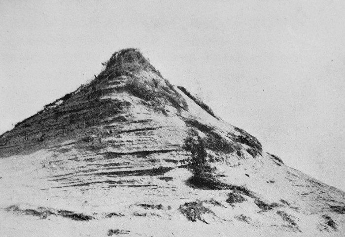 A PEAKED DUNE 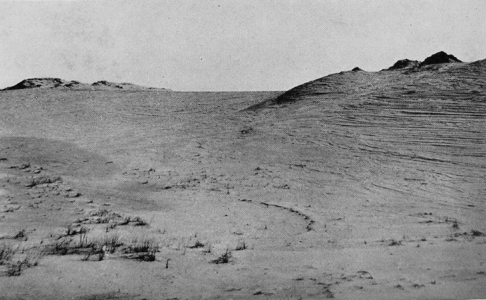 SHOWING BOTH THE STEEP WINDWARD FACE BY CUTTING, AND THE GENTLE WIND-SWEPT SLOPE Half
buried in the
dunes is the Ipswich lighthouse, even whiter than the sands. In 1809,
James F.
Lakeman sold to James Madison, the President of the United States,
eighteen
hundred square feet in these sandy wastes “for the purpose of erecting
a
beacon.” In 1837, Captain Lakeman sold four acres to the United States
for the
erection of a lighthouse. In the deed it is stated that the northern
corner of
this lot was “about five rods [82 1/2 ft.] from water mark and beach.”
This
same corner is now [1911] about a thousand and ninety feet from
high-water
mark, while the light itself is eleven hundred and forty feet from the
upper
edge of the beach. The old
light-keeper, Captain Ellsworth, who died in 1902, told me that when he
took
charge in 1861, he used to be able to talk from the lighthouse to men
in boats
in the water. In the line between the main light, — which slowly
revolves with
a long and a short flash and a period of darkness, — and the mouth of
the
Ipswich River is the range-light, which consists of a powerful lantern
in a
small wooden house. As the mouth of the Ipswich River where it enters
the sea
between treacherous bars is a long way to the southeast of the
apparent mouth
of the river and constantly shifting, the site of the range-light has
to be
changed every five or six years. In the
summer of
1910 there emerged from the dunes within five hundred and forty feet of
the
lighthouse the timbers of an old vessel, which must have been wrecked
many
years before, when that spot was within the reach of the tides. Now it
is six
hundred feet from high-tide mark. One of the old inhabitants said he
remembered
the wreck, and treasured the year 1863 in his memory as the date when
the
catastrophe occurred. Be that as it may, the old wreck at this point
serves to
confirm the story of the lighthouse-keeper’s conversation in bygone
days with
men in boats on the water. The speedy way in which the sands swallow up wrecks was well shown by the fate of an old schooner that went ashore in the Christmas storm of 1909. The skipper had sold his farm and invested his all in the vessel, and this was his first trip for a load of sand from the perpetual supply on Plum Island. The gale swept down from the northeast thick with snow, the anchors dragged, there was not sea room enough to manoeuvre away from the lee shore, and he was wrecked on the beach at high tide. The poor man begged for farming work again, for there was no probability of saving his schooner, which, with every pound of the surf, settled deeper and deeper in the sand. Less than a year later she was buried to the deck. 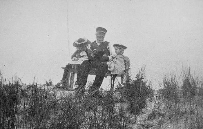 THE OLD LIGHTHOUSE KEEPER AND SOME OF HIS FRIENDS 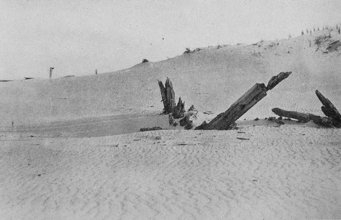 WRECK UNCOVERED AFTER MANY YEARS FAR IN THE DUNES, SHOWING ALSO RIPPLE-MARKS In the
seventies I
used occasionally to take the long walk from Magnolia to Coffin’s
Beach, which
lies the other side of the Essex River from Ipswich, to spend a
solitary day
among its strange dunes and on its long flat beach. As I lay in my
blind there,
intent on shooting the wandering shore birds, I often thought of the
tale of
Coffin’s farm. When the old farmer was on his death-bed he gathered his
sons
about him and gave them his farm, and at the same time bade them never
to cut
the woods that lay between the farm and the sea. Scarcely was the old
man
buried than his words were forgotten by the thoughtless sons, who,
instead of
going farther afield for their wood, took that nearest at hand. As a
result of
their disobedience the winds were no longer restrained, the sand blew
in and
overwhelmed the fair fields, and now the tops only of a few apple trees
extending above the sand show what the place once was.1 The same catastrophe has occurred at Ipswich. In the middle of the dunes on the marsh side is a long hill about sixty feet high, so covered with sand that it is generally considered a great dune. In some places, however, one can scratch the sand and find earth and gravel below; occasionally a boulder projects, and here and there one comes on ancient stone walls, some of which have been uncovered by the blowing sand within a few years. In 1892 there was an orchard near the top and on the southwesterly slope, somewhat less than an acre in extent. Part of this orchard was still nearly unscathed by the advancing sand, which had merely dusted the ground, but the rest was buried to the tops of the main trunks, and all the horizontal and drooping limbs were covered, yet the topmost branches blossomed and bore fruit. But the sand encroached more and more, and one after another the strangled trees gave up the ghost, and the tops only of dead branches stretched above the sand. The struggle was a hard one, and for many years some of the braver tree-tops blossomed with cheerful promise in the waste of sand, but came to no fulfilment of fruit. In 1910 all I could find to mark the place were a few wind- and sand-beaten apple-branches. The orchard was entirely buried in the white sand!  THE HALF-BURIED APPLE ORCHARD IN 1892  ALL THAT REMAINED OF THE ORCHARD IN 1910 The
seaward side of
this drumlin, for drumlin it is, on which the old Lakeman farm once
flourished, is in places a precipitous gravel cliff more or less
whitened with
sand. This cliff shows as surely as if it had stated the fact in words,
that at
one time waves of water, not of sand as at present, beat against its
foot. The
distance from the foot of this ancient sea-cliff to the sea, now filled
in by
sand dunes, is about twenty-four hundred feet. We have just seen that a
vessel
that went ashore near the lighthouse is now, after the lapse of about
fifty
years, some six hundred feet from the upper edge of the beach, so we
might
calculate that the sea beat at the foot of this gravel cliff about two
hundred
years ago. This, however, is not a safe estimate, and may be wide of
the truth,
for the beach and dunes are continually changing with changing sets of
tide and
currents, and while one part is building out another part may be
washing away. Yet this
estimate
just given is confirmed by an ancient manuscript map, now in the
possession of
Mr. R. T. Crane, Jr., to whom I am indebted for a photographic
reproduction
given here. This is entitled “A Representation of Castle Hill &
Castle
Neck with ye adjacent Sea, Rivers Creeks Hills Islands and Marshes,
Protracted
from a scale of forty rods to an Inch. P. B. Dodge Ipswich April 3
1786.” The
old Lakeman farm was then inhabited by grandfather Choate, and the
hill we
have just been considering is called “Wig-wom Hill.” The foot of the
hill is
distant from the sea, according to the map, some eighty rods, or
thirteen
hundred and twenty feet. As the sea is now twenty-four hundred feet
off, the
dunes have gained eleven hundred feet in one hundred and twenty-four
years.
This corresponds fairly closely with the approximation of six hundred
feet in
fifty years obtained from the old wreck. The southeastern end of the dunes do not extend beyond Hog Island in this map, and the distance from the farmhouse of Wigwam Hill to the end is about a mile. At the present day the distance is fully two and a half miles. I do not feel sure, however, of the accuracy of the scale of this map, although I may do the author an injustice. There are some other points shown by the map which, however, do not depend on scale, and are interesting as showing the changes that have taken place. One of these is the indication of trees or woods at the inner end of the point of the dunes, where no woods exist now; another is the “New Channel” between the end of Plum Island and Ipswich “Barr,” which is now entirely obliterated; and the third is the extension seaward of Steep Hill, the northeastern peak of Castle Hill. This latter point is more clearly shown on the map of 1846 made by Aaron Cogswell. Here the contour line shows a gradual sloping of Steep Hill to the beach with a field labelled “pasture” between, in which is a “Bass Tree.” The distance from the highest point on the hill to tide mark is about five hundred and twenty feet. At the present time the pasture and the bass tree are obliterated, while the northerly slope of the hill has become a cliff whose crest is on a level with the top of the hill; the tides wash its base. Thus it were better to build one’s house on the shifting sand which grows and endures than on the rocky hills that sink into the sea. 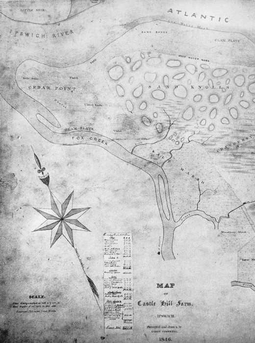  MAP OF CASTLE HILL FARM, 1846 In winter among the dunes the snow and sand are drifted mingled together or separately, and one often finds a deep white snowbank beneath a skimming of sand, which, if the snow is melting, is darker than the surrounding dry sand. Other signs of buried snow are the deep fissures formed in the sand by the contracting snowbanks, and the crunching sound that issues when one walks over the concealed snow. One of the largest snowbanks, which became almost a glacier, I watched during the severe winter of 1903-4. This was an immense drift of snow and sand, separate and commingled, encroaching on the north side of the grove of pitch pines. A layer of sand from one to two feet in thickness, which reflected but did not so easily conduct the sun’s rays, so protected the snow that it became compact and crystalline. On May 15th, this crystalline snow had a thickness of thirty-eight inches at its exposed face, under which, extending back to a distance of three feet, was a “glacial” cavern. The sand on top was cracked and crevassed, and this, together with the bending of the trees, suggested the possibility of some motion down the slope. On May 30th, the face of the “glacier” was covered with sand, but marks made on a tree showed that the drift had sunk forty-two inches since May 8th. A week later, on June 6th, I dug for the glacier but could not find it. 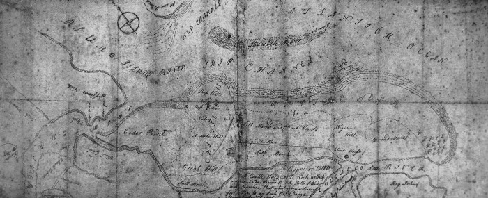 MAP OF IPSWICH SAND DUNES, 1786 While
these
snowbanks in the dunes are suggestive of alpine glaciers, the ice
formations
on the beach and ocean are suggestive of the polar seas. Both are
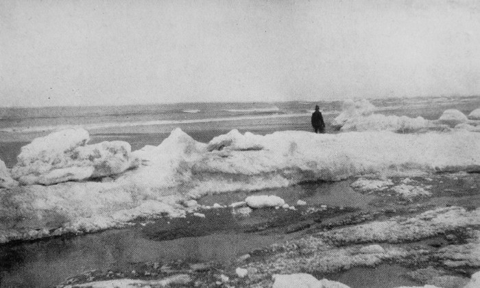
miniatures of
the real thing. During severe frosts an ice cliff forms at the upper
edge of
the beach, and this presents to the advancing tide a sea-wall from two
to eight
feet high. Against this the waves beat, and the spray flung up on the
top
freezes and adds to the height. While the top is fairly smooth, except
where it
is eaten away by the waves that have broken through it, the sea façade
is
hollowed into caverns or built out in parapets and festooned here and
there
with icicles. Although
the beach
itself, uncovered by the tide, is generally free from ice, it is
occasionally
glazed over and strewn with great cakes that in zero weather extend out
over
the water to form in places a solid shelf, — an “ice-foot.” But in most
places,
during weather like this the ocean is beset with floating cakes of ice,
and
with newly forming ice which in the heaving and churning of the sea
appears
like grains of sago, and later takes the form of small rounded or
many-sided
cakes with raised edges, the “slob-ice” of the Labrador coast, the
“pancake
ice” of Scorseby. Everywhere beyond the ice and in the open leads the
sea
seems to boil and great clouds of mist roll upward, for the warmer
water of the
sea actually steams in this arctic weather, and the distant view is
obscured.
Here are patches and lanes of black water, there, bands of solid floe
brilliantly white in the sunlight. Icebergs, the most magnificent
arctic
phenomena, once seen, always to be treasured in the memory, do not
appear on
this coast. It is far too distant from the parent glaciers. On one occasion, in February, when the thermometer was six degrees below zero, and the water was covered with pancake ice, I heard in the still air a sighing, whistling note, an aeolian-harp-like sound, which appeared to have its source in the heaving, churning ice-cakes.  “GLACIER DUNE” SHOWING THE CRACKED SAND AND THE UNDERLYING SNOW 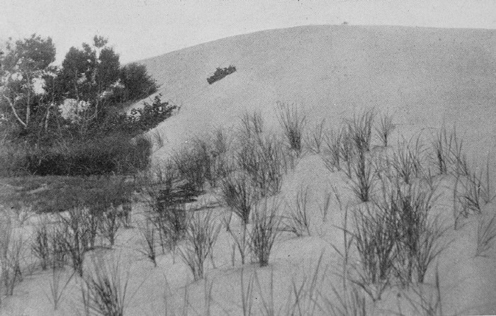 DUNE OVERWHELMING BIRCH GROVE, SHOWING THE STEEP LEEWARD SIDE Another
interesting
phenomenon of arctic weather is the geyser-like bubbling occasionally
seen
along the beach at high tide in two or three feet of water. For minutes
at a
time geysers a foot in diameter belch forth great streams of air which
throw
the water up in miniature fountains. The explanation of this seems
rather
obscure, but I have thought that a sudden severe frost at the time of
the ebb
had sealed the surface of the sand, and the water, escaping beneath,
had left
numerous interstices into which the air permeated, to escape when the
warm
water of the rising tide melted the ice seal and forced out the air.
Possibly
the presence of dead thatch grass, thrown up and buried in the sand,
aided in
the accumulation of air. This phenomenon is very different from the
tiny air
spouts that arise from the burrows of beach fleas. As one
walks along
the edge of the dunes near the beach in summer or winter, his
attention may be
attracted by a number of balls which appear to be made up of broken
pieces of
straw or grass. Some of these are not larger than a tennis ball, others
the
size of a cocoanut; some are perfectly spherical and firmly matted,
others are
loosely formed and often elongated in shape. Similar grass balls were
found by
Thoreau on the shores of Flint’s Pond in Lincoln, and they appear to
have
puzzled him considerably. It is evident from a careful study of a
series of
these balls and by actually watching their formation, that they are
gradually
built up in shallow water near the shore by the rolling action of the
waves on
particles of broken thatch, sticks, seaweed and grass which have
collected in
hollows and ripple-marks. A nucleus once started, more and more
material is
added as the ball rolls about. These balls are to be distinguished from the hair balls, also occasionally found on the beach, that are formed in the stomachs of cattle, as well as from the balls formed by the rolling about of pieces of submerged marsh sod, which often take on a rounded pebble shape.
 ICE WALL 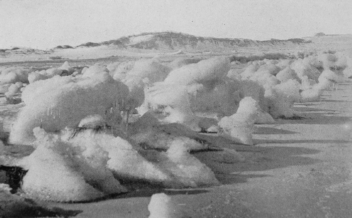 ICE WALL
_________________________
1 In Babson’s History of Gloucester,
published in 1860,
it, is stated that Peter Coffin, after failing at law and business,
“went onto
the farm, where he lived as long as it would yield him a support by the
sale of
the wood upon it, and then came back to town, and died Aug. 4, 1821,
aged
seventy-two.” |
 Click the book image to turn to the next Chapter.