Web
and Book design, Web
and Book design, Copyright, Kellscraft Studio 1999-2003 (Return to Web Text-ures) |
Click Here to return to Inca Lands Content Page Click Here to return to previous chapter |
 (HOME) |
| Web
and Book design, Copyright, Kellscraft Studio 1999-2003 (Return to Web Text-ures) |
Click Here to return to Inca Lands Content Page Click Here to return to previous chapter |
(HOME) |
|
CHAPTER
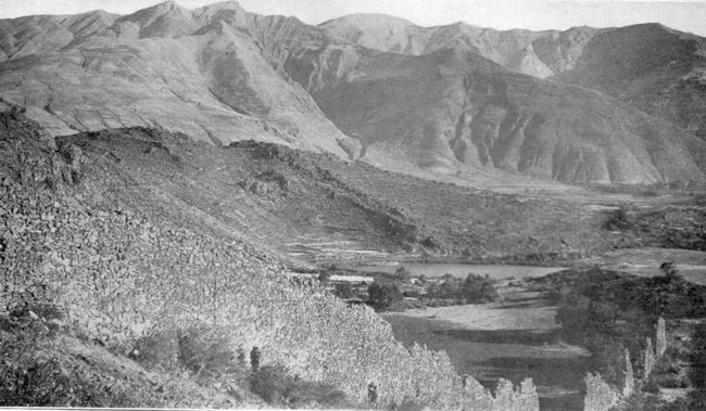
VII THE VALLEY OF THE HUATANAY THE valley of the
Huatanay is
one of many valleys
tributary to the Urubamba. It differs from them in having more arable
land
located under climatic conditions favorable for the raising of the food
crops
of the ancient Peruvians. Containing an area estimated at less than 160
square
miles, it was the heart of the greatest empire that South America has
ever
seen. It is still intensively cultivated, the home of a large
percentage of the
people of this part of Peru. The Huatanay itself sometimes meanders
through the
valley in a natural manner, but at other times is seen to be confined
within
carefully built stone walls constructed by prehistoric agriculturists
anxious
to save their fields from floods and erosion. The climate is temperate.
Extreme
cold is unknown. Water freezes in the lowlands during the dry winter
season, in
June and July, and frost may occur any night in the year above 13,000
feet, but
in general the climate may be said to be neither warm nor cold. This rich valley was
apportioned by the Spanish
conquerors to soldiers who were granted large estates as well as the
labor of
the Indians living on them. This method still prevails and one may
occasionally
meet on the road wealthy landholders on their way to and from town.
Although
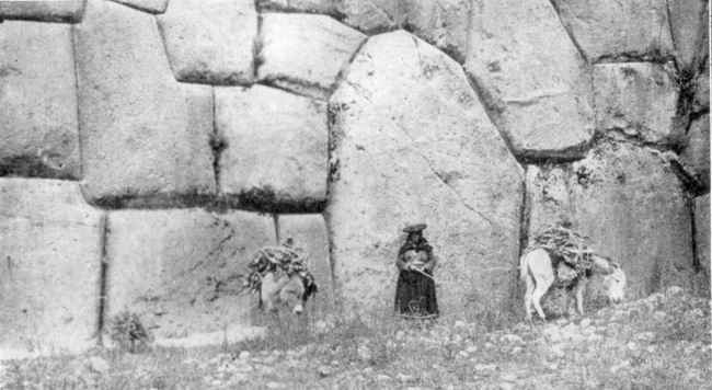
mules that this was an Inca fortress, intended to separate the chiefs
of Cuzco
from those of Vilcanota. It is now locally referred to as a “fortaleza.”
The major part of the wall is well built of rough stones, laid in clay,
while
the sides of the gateway are faced with carefully cut andesite ashlars
of an
entirely different style. It is conceivable that some great chieftain
built the
rough wall in the days when the highlands were split up among many
little
independent rulers, and that later one of the Incas, no longer needing
any
fortifications between the Huatanay Valley and the Vilcanota Valley,
tore down
part of the wall and built a fine gateway. The faces of the ashlars are
nicely
finished except for several rough bosses or nubbins. They were probably
used by
the ancient masons in order to secure a better
hold when finally adjusting the ashlars with small
crowbars. It may have
been the intention of the stone masons to remove these nubbins after
the wall
was completed. In one of the unfinished structures at Machu Picchu I
noticed
similar bosses. The name “Stone-granary” was probably originally
applied to a
neighboring edifice now in ruins. On the rocky hillside
above
Rumiccolca are the ruins
of many ancient terraces and some buildings. Not far from Rumiccolca,
on the
slopes of Mt. Piquillacta, are the ruins of an extensive city, also
called
Piquillacta. A large number of its houses have extraordinarily high
walls. A
high wall outside the city, and running north and south, was obviously
built to
protect it from enemies approaching from the Vilcanota Valley. In the
other
directions the are essentially the most reliable saddle animals for
work in the
Andes, these landholders usually prefer horses, which are larger and
faster, as
well as being more gentle and better gaited. The gentry of the Huatanay
Valley
prefer a deep-seated saddle, over which is laid a heavy sheepskin or
thick fur
mat. The fashionable stirrups are pyramidal in shape, made of wood
decorated
with silver bands. Owing to the steepness of the roads, a crupper is
considered
necessary and is usually decorated with a broad, embossed panel, from
which
hang little trappings reminiscent of medieval harness. The bridle is
usually
made of carefully braided leather, decorated with silver and frequently
furnished with an embossed leather eye shade or blinder, to indicate
that the
horse is high-spirited. This eye shade, which may be pulled down so as
to blind
both eyes completely, is more useful than a hitching post in persuading
the
horse to stand still. The valley of the
Huatanay
River is divided into three
parts, the basins of Lucre, Oropesa, and Cuzco. The basaltic cliffs
near
Oropesa divide the Lucre Basin from the Oropesa Basin. The pass at
Angostura,
or “the narrows,” is the natural gateway between the Oropesa Basin and
the
Cuzco Basin. Each basin contains interesting ruins. In the Lucre Basin
the most
interesting are those of Rumiccolca and Piquillacta. At the extreme
eastern end of
the valley, on top of
the pass which leads to the Vilcanota is an ancient gateway called
Rumiccolca (Rumi
= “stone”; ccolca = “granary”). It is commonly
supposed slopes are so
steep as to render a wall unnecessary. The walls are built of fragments
of lava
rock, with which the slopes of Mt. Piquillacta are covered. Cacti and
thorny
scrub are growing in the ruins, but the volcanic soil is rich enough to
attract
the attention of agriculturists, who come here from neighboring
villages to
cultivate their crops. The slopes above the city are still extensively
cultivated, but without terraces. Wheat and barley are the principal
crops. As an illustration of
the
difficulty of identifying
places in ancient Peru, it is worth noting that the gateway now called
Rumiccolca is figured in Squier’s “Peru” as “Piquillacta.” On the other
hand,
the ruins of the large city, “covering thickly an area nearly a square
mile,”
are called by Squier “the great Inca town of Muyna,” a name also
applied to the
little lake which lies in the bottom of the Lucre Basin. As Squier came
along
the road from Racche he saw Mt. Piquillacta first, then the gateway,
then Lake
Muyna, then the ruins of the city. In each case the name of the most
conspicuous, harmless, natural phenomenon seems to have been applied to
ruins
by those of whom he inquired. My own experience was different.
Dr. Aguilar, a
distinguished
professor in the
University of Cuzco, who has a country place in the neighborhood and is
very
familiar with this region, brought me to this ancient city from the
other
direction. From him I learned that the city ruins are called
Piquillacta, the
name which is also applied to the mountain which lies to the eastward
of the
ruins and rises 1200 feet
above
them. Dr. Aguilar lives near Oropesa. As one comes from Oropesa, Mt.
Piquillacta is a conspicuous point and is directly in line with the
city ruins.
Consequently, it would be natural for people viewing it from this
direction to
give to the ruins flue name of the mountain rather than that of the
lake. Yet
the mountain may be named for the ruins. Piqui means
“flea”; llacta
means “town, city, country, district, or territory.” Was this
“Territory of the
Fleas” or was it “Flea Town”? And what was it a name in the clays of
the Incas?
Was the old name abandoned because it was considered unlucky? Whatever the reason,
it is a
most extraordinary fact
that we have here the evidences of a very large town, possibly
pre-Inca, long
since abandoned. There are scores of houses and numerous compounds laid
out in
regular fashion, the streets crossing each other at right angles, the
whole
covering an area considerably larger than the important town of
Ollantaytambo.
Not a soul lives here. It is true that across the Vilcanota to the cast
is a
difficult, mountainous country culminating in Mt. Ausangate, the
highest peak
in the department. Yet
Piquillacta is in the midst of a populous region. To the north lies the
thickly
settled valley of Pisac and Yucay; to the south, the important
Vilcanota Valley
with dozens of villages; to the west the densely populated valley of
the
Huatanay and Cuzco itself, the largest city in the highlands of Peru.
Thousands
of people live within a radius of twenty miles of Piquillacta, and the
population is on the increase. It is perfectly easy of access and is
less than
a mile east of the railroad. Yet it is “abandonado
— desierto — despoblado”! Undoubtedly here was once a large
city of great
importance. The reason for its being abandoned appears to be the
absence of
running water. Although Mt. Piquillacta is a large mass, nearly five
miles long
and two miles wide, rising to a point of 2000 feet above the Huatanay
and
Vilcanota rivers, it has no streams, brooks, or springs. It is an
isolated,
extinct volcano surrounded by igneous rocks, lavas, andesites, and
basalts. How came it that so
large a
city as Piquillacta
could have been built on the slopes of a mountain which has no running
streams?
Has the climate changed so much since those days? If so, how is it that
the
surrounding region is still the populous part of southern Peru? It is
inconceivable that so large a city could have been built and occupied
on a
plateau four hundred feet above the nearest water unless there was some
way of
providing it other than the arduous one of bringing every drop up the
hill on
the backs of men and llamas. If there were no places near here better
provided
with water than this site, one could understand that perhaps its
inhabitants
were obliged to depend entirely upon water carriers. On the contrary,
within a
radius of six miles there are half a dozen unoccupied sites near
running
streams. Until further studies can be made of this puzzling problem I
believe
that the answer lies in the ruins of Rumiccolca, which are usually
thought of
as a fortress. Squier says that this
“fortress” was “the southern
limit of the dominions of the first Inca.” “The fortress reaches from
the
mountain, on one side, to a high, rocky eminence on the other. It is
popularly
called ‘El Aqueducto,’ perhaps
from some fancied resemblance to an aqueduct — but the name is
evidently
misapplied.” Yet he admits that the cross-section of the wall,
diminishing as
it does “by graduations or steps on both sides,” “might appear to
conflict with
the hypothesis of its being a work of defense or fortification” if it
occupied
“a different position.” He noticed that “the top of the wall is
throughout of
the same level; becomes less in height as it approaches the hills on
either
hand and diminishes proportionately in thickness” as an aqueduct should
do.
Yet, so possessed was he by the “fortress” idea that he rejected not
only local
tradition as expressed in the native name, but even turned his back on
the
evidence of his own eyes. It seems to me that there is little doubt
that
instead of the ruins of Rumiccolca representing a fortification, we
have here
the remains of an ancient azequia, or aqueduct,
built by some powerful chieftain to supply the people of Piquillacta
with
water. A study of the
topography of
the region shows that
the river which rises southwest of the village of Lucre and furnishes
water
power for its modern textile mills could have been used to supply such
an azequia. The water, collected
at an
elevation of 10,700 feet, could easily have been brought six miles
along the
southern slopes of the Lucre Basin, around Mt. Rumiccolca and across
the old
road, on this aqueduct, at an elevation of about 10,600 feet. This
would have
permitted it to flow through some of the streets of Piquillacta and
give the
ancient city an adequate supply of water. The slopes of Rumiccolca are
marked
by many ancient terraces. Their upper limit corresponds roughly with
the
contour along which such an azequia would
have had to pass. There is, in fact, a distinct line on the hillside
which
looks as though an azequia had
once
passed that way. In the valley back of Lucre are also faint indications
of old azequias. There has been,
however, a
considerable amount of erosion on the hills, and if, as seems likely,
the
water-works have been out of order for several centuries, it is not
surprising
that all traces of them have disappeared in places. I regret very much
that
circumstances over which I had no control prevented my making a
thorough study
of the possibilities of such a theory. It remains for some fortunate
future
investigator to determine who were the inhabitants of Piquillacta, how
they
secured their water supply, and why the city was abandoned.
Until then I suggest
as a
possible working
hypothesis that we have at Piquillacta the remains of a pre-Inca city;
that its
chiefs and people cultivated the Lucre Basin and its tributaries; that
as a
community they were a separate political entity from the people of
Cuzco; that
the ruler of the Cuzco people, perhaps an Inca, finally became
sufficiently
powerful to conquer the people of the Lucre Basin, and removed the
tribes which
had occupied Piquillacta to a distant part of his domain, a system of
colonization well known in the history of the Incas; that, after the
people who
had built and lived in Piquillacta departed, no subsequent dwellers in
this
region cared to reoccupy the site, and its aqueduct fell into decay. It
is easy
to believe that at first such a site would have been considered
unlucky. Its
houses, unfamiliar and unfashionable in design, would have been
considered not
desirable. Their high walls might have been used for a reconstructed
city had
there been plenty of water available. In any case, the ruins of the
Lucre Basin
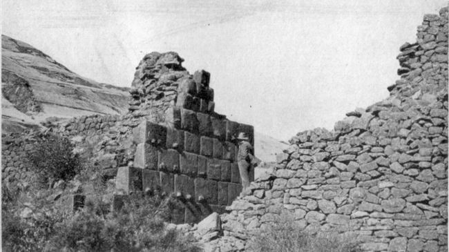
offer a most fascinating problem. In the Oropesa Basin
the most
important ruins are
those of Tipon, a pleasant, well-watered valley several hundred feet
above the
village of Quispicanchi. They include carefully constructed houses of
characteristic Inca construction, containing many symmetrically
arranged niches
with stone lintels. The walls of most of the houses are of rough stones
laid in
clay. Tipon was probably the residence of the principal chief of the
Oropesa
Basin. It commands a pleasant view of the village and of the hills to
the
south, which to-day are covered with fields of wheat and barley. At
Tipon there
is a nicely constructed fountain of cut stone. Some of the terraces are
extremely well built, with roughly squared blocks fitting tightly
together.
Access from one terrace to another was obtained by steps made each of a
single
bonder projecting from the face of the terrace. Few better constructed
terrace
walls are to be seen anywhere. The terraces are still cultivated by the
people
of Quispicanchi. No one lives at Tipon now, although little shepherd
boys and
goatherds frequent the neighborhood. It is more convenient for the
agriculturists to live at the edge of their largest fields, which are
in the
valley bottom, than to climb five hundred feet into the narrow valley
and
occupy the old buildings. Motives of security no longer require a
residence
here rather than in the open plain. While I was examining
the ruins
and digging up a few
attractive potsherds bearing Inca designs, Dr. Giesecke, the President
of the
University of Cuzco, who had accompanied me, climbed the mountain above
Tipon
with Dr. Aguilar and reported the presence of a fortification near its
summit.
My stay at Oropesa was rendered most comfortable and happy by the
generous
hospitality of Dr. Aguilar, whose finca is between
Quispicanchi and
‘Oropesa and commands a charming view of the valley. From the Oropesa
Basin, one
enters the Cuzco Basin
through an opening in the sandstone cliffs of Angostura near the modern
town of
San Geronimo. On the slopes above the south bank of the Huatanay, just
beyond
Angostura, are the ruins of a score or more of gable-roofed houses of
characteristic Inca construction. The ancient buildings have doors,
windows,
and niches in walls of small stones laid in clay, the lintels having
been of
wood, now decayed. When we asked the name of these ruins we were told
that it
was Saylla, although that is the name of a modern village three miles
away,
down the Huatanay, in the Oropesa Basin. Like Piquillacta, old Saylla
has no
water supply at present. It is not far from a stream called the Kkaira
and
could easily have been supplied with water by an azequia
less than two miles in length brought along the 11,000
feet
contour. It looks very much like the case of a village originally
placed on the
hills for the sake of comparative security and isolation arid later
abandoned
through a desire to enjoy the advantages of living near the great
highway in
the bottom of the valley, after the Incas had established over the
highlands.
There may be another explanation. It appears from Mr.
Cook’s
studies that the
deforestation of the Cuzco Basin by the hand a man, and modern methods
of
tillage on unterraced slopes, have caused an unusual amount of erosion
to
occur. Landslides are frequent in the rainy season. Opposite Saylla is
Mt. Picol,
whose twin peaks are
the most conspicuous feature on the north side of the basin. Waste
material
from its slopes is causing the rapid growth of a great gravel fan north
of the
village of San Geronimo. Professor Gregory noticed that the streams
traversing
the fan are even now engaged in burying ancient fields by “transporting
gravel
from the head of the fan to its lower margin,” and that the lower end
of the
Cuzco Basin, where the Huatanay, hemmed in between the Angostura
Narrows,
cannot carry away the sediment as fast as it is brought down by its
tributaries, is being choked up. If old Saylla represents a fortress
set here
to defend Cuzco against old Oropesa, it might very naturally have been
abandoned when the rule of the Incas finally spread far over the Andes.
On the
other hand, it seems more likely that the people who built Saylla were
farmers
and that when the lower Cuzco Basin was filled up by aggradation, due
to
increased erosion, they abandoned this site for one nearer the arable
lands.
One may imagine the dismay with which the agricultural residents of
these
ancient houses saw their beautiful fields at the bottom of the hill,
covered in
a few days, or even hours, by enormous quantities of coarse gravel
brought down
from the steep slopes of Picol after some driving rainstorm. It may
have been
some such catastrophe that led them to take up their residence
elsewhere. As a
matter of fact we do not know when it was abandoned. Further
investigation
might point to its having been deserted when the Spanish village of San
Geronimo was founded. However, I believe students of agriculture will
agree
with me that deforestation, increased erosion, and aggrading gravel
banks
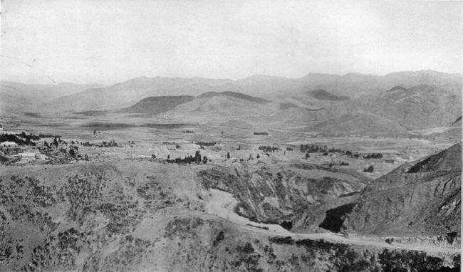
probably drove the folk out of Saylla. The southern rim of
the Cuzco
Basin is broken by no
very striking peaks, although Huanacaurai (13,427 ft.), the highest
point, is
connected in Inca tradition with some of the principal festivals and
religious
celebrations. The north side of the Huatanay Valley is much more
irregular,
ranging from Ttica Ttica pass (12,000 ft.) to Mt. Pachatucsa (15,915
ft.),
whose five little peaks are frequently snow-clad. There is no permanent
snow
either here or elsewhere in the Huatanay Valley. The people of the
Cuzco Basin
are very short of
fuel. There is no native coal. What the railroad uses comes from
Australia.
Firewood is scarce. The ancient forests disappeared long ago. The only
trees in
sight are a few willows or poplars from Europe and one or two groves of
eucalyptus, also from Australia. Cuzco has been thought of and written
of as
being above the tree line, but such is not the case. The absence of
trees on
the neighboring hills is due entirely to the hand of man, the long
occupation,
the necessities of early agriculturists, who cleared the forests before
the
days of intensive terrace agriculture, and the firewood requirements of
a large
population.
The people of Cuzco do not dream of having enough fuel
to make
their houses warm and comfortable. Only with difficulty can they get
enough for
cooking purposes. They depend largely on fagots and straw which are
brought
into town on the backs of men and animals. In the fields of
stubble left
from the wheat and
barley harvest we saw many sheep feeding. They were thin and
long-legged and
many of the rains had four horns, apparently due to centuries of
inbreeding and
the failure to improve the original stock by the introduction of new
and
superior strains. When one looks at the
great
amount of arable slopes
on most of the hills of the Cuzco Basin and the unusually extensive
flat land
near the Huatanay, one readily understands why the heart of Inca Land
witnessed
a concentration of population very unusual in the Andes. Most of the
important
ruins are in the northwest quadrant of the basin either in the
immediate
vicinity of Cuzco itself or on the “pampas” north of the city. The
reason is
that the arable lands where most extensive potato cultivation could be
carried
out are nearly all in this quadrant. In the midst of this potato
country, at
the foot of the pass that leads directly to Pisac and Paucartambo, is a
picturesque ruin which bears the native name of Pucára. Pucára
is the Quichua word for fortress and it needs but one glance at the
little
hilltop crowned with a rectangular fortification to realize that the
term is
justified. The walls are beautifully made of irregular blocks closely
fitted
together. Advantage was taken of small cliffs on two sides of the hill
to
strengthen the fortifications. We noticed openings or drains which had
been cut
in the wall by the original builders in order to prevent the
accumulation of
moisture on the terraced floor of the enclosed area, which is several
feet
above that of the sloping field outside. Similar conduits may be seen
in many
of the old walls in the city of Cuzco. Apparently, the ancient folk
fully
appreciated the importance of good drainage and took pains to secure
it. At
present Pucára is occupied by llama herdsmen and drovers, who find the
enclosure a very convenient corral. Probably Pucára was built by the
chief of a
tribe of prehistoric herdsmen who raised root crops and kept their
flocks of
llamas and alpacas on the neighboring grassy slopes. A short distance up
the stream
of the Lkalla Chaca,
above Pucára, is a warm mineral spring. Around it is a fountain of cut
stone.
Near by are the ruins of a beautiful terrace, on top of which is a fine
wall
containing four large, ceremonial niches, level with the ground and
about six
feet high. The place is now called Tampu Machai. Polo de Ondegardo, who
lived
in Cuzco in 1560, while many of the royal family of the Incas were
still alive,
gives a list of the sacred or holy places which were venerated by all
the
Indians in those days. Among these he mentions that of Timpucpuquio,
the “hot
springs” near Tambo Machai, “called so, from the manner in which the
water
boils up.” The next huaca, or holy place, he
mentions is Tambo Machai
itself, “a house of the Inca Yupanqui, where he was entertained when he
went to
be married. It was placed on a hill near the road over the Andes. They
sacrifice everything here except children.” The stonework of the
ruins here
is so excellent in
character, the ashlars being very carefully fitted together, one may
fairly
assume a religious origin for the place. The Quichua word macchini
means
“to wash” or “to rinse a large narrow-mouthed pitcher.” It may be that
at Tampu
Machai ceremonial purification of utensils devoted to royal or priestly
uses
was carried on. It is possible that this is the place where, according
to
Molina, all the youths of Cuzco who had been armed as knights in the
great
November festival came on the 21st day of the month to bathe and change
their
clothes. Afterwards they returned to the city to be lectured by their
relatives. “Each relation that offered a sacrifice flogged a youth and
delivered a discourse to him, exhorting him to be valiant and never to
be a
traitor to the Sun and the Inca, but to imitate the bravery and prowess
of his
ancestors.” Tampu Machai is located on a little bluff above the Lkalla Chaca, a small stream which finally joins the Huatanay near the town of San Sebastian. Before it reaches the Huatanay, the Lkalla Chaca joins the Cachimayo, famous as being so highly impregnated with salt as to have caused the rise of extensive salt works. In fact, the Pizarros named the place Las Salinas, or “the Salt Pits,” on account of the salt pans with which, by a careful system of terracing, the natives had filled the Cachimayo Valley. Prescott describes the great battle which took place here on April 26, 1539, between the forces of Pizarro and Almagro, the two leaders who had united for the original conquest of Peru, but quarreled over the division of the territory. Near the salt pans are many Inca walls and the ruins of structures, with niches, called Rumihuasi, or “Stone House.” The presence of salt in many of the springs of the Huatanay Valley was a great source of annoyance to our topographic engineers, who were frequently obliged to camp in districts where the only water available was so saline as to spoil it for drinking purposes and ruin the tea. The Cuzco Basin was
undoubtedly
once the site of a
lake, “an ancient water-body whose surface,” says Professor Gregory,
“lay well
above the present site of San Sebastian and San Geronimo.” This lake is
believed to have reached its maximum expansion in early Pleistocene
times. Its
rich silts, so well adapted for raising maize, habas
beans, and quinoa, have
always attracted farmers and are still intensively cultivated. It has
been
named “Lake Morkill” in honor of that loyal friend of scientific
research in
Peru, William L. Morkill, Esq., without whose untiring aid we could
never have
brought our Peruvian explorations as far along as we did. In
pre-glacial times
Lake Morkill fluctuated in volume. From time to time parts of the shore
were
exposed long enough to enable, plants to send their roots into the fine
materials and the sun to bake and crack the muds. Mastodons grazed on
its
banks. “Lake Morkill probably existed during all or nearly all of the
glacial
epoch.” Its drainage was finally accomplished by the Huatanay cutting
down the
sandstone hills, near Saylla, and developing the Angostura gorge. In the banks of the
Huatanay, a
short distance below
the city of Cuzco, the stratified beds of the vanished Lake Morkill
to-day
contain many fossil shells. Above these are gravels brought down by the
floods
and landslides of more modern times, in which may be found potsherds
and bones.
One of the chief affluents of the Huatanay is the Chunchullumayo, which
cuts
off the southernmost third of Cuzco from the center of the city. Its
banks are
terraced and are still used for gardens and food crops. Here the
hospitable
Canadian missionaries have their pleasant station, a veritable oasis of
Anglo-Saxon
cleanliness. On a July morning in
1911,
while strolling up the Ayahuaycco
quebrada, an affluent of the
Chunchullumayo, in company with Professor Foote and Surgeon Erving, my
interest
was aroused by the sight of several bones and potsherds exposed by
recent
erosion in the stratified gravel banks of the little gulch. Further
examination
showed that recent erosion had also cut through an ancient ash heap. On
the
side toward Cuzco I discovered a section of stone wall, built of
roughly
finished stones more or less carefully fitted together, which at first
sight
appeared to have been built to prevent further washing away of that
side of the
gulch. Yet above the wall and flush with its surface the bank appeared
to
consist of stratified gravel, indicating that the wall antedated the
gravel
deposits. Fifty feet farther up the quebrada
another portion of wall appeared under the gravel bank.
On top of the bank
was a cultivated field! Half an hour’s digging in the compact gravel
showed
that there was more wall underneath the field. Later investigation by
Dr.
Bowman showed that the wall was about three feet thick and nine feet in
height,
carefully faced on both sides with roughly cut stone and filled in with
rubble,
a type of stonework not uncommon in the foundations of some of the
older
buildings in the western part of the city of Cuzco.
Even at first sight
it was
obvious that this wall,
built by man, was completely covered to a depth of six or eight feet by
a
compact water-laid gravel bank. This was sufficiently difficult to
understand,
yet a few days later, while endeavoring to solve the puzzle, I found
something
even more exciting. Half a mile farther up the gulch, the road, newly
cut, ran
close to the compact, perpendicular gravel bank. About five feet above
the road
I saw what looked like one of the small rocks which are freely
interspersed
throughout the gravels here. Closer examination showed it to be the end
of a
human femur. Apparently it formed an integral part of the gravel bank,
which
rose almost perpendicularly for seventy or eighty feet above it.
Impressed by
the possibilities in case it should turn out to be true that here, in
the heart
of Inca Land, a human bone had been buried under seventy-five feet of
gravel, I
refrained from disturbing it until I could get Dr. Bowman and Professor
Foote,
the geologist and the naturalist of the 1911 Expedition, to come with
me to the
Ayahuaycco quebrada. We excavated the femur and found behind it
fragments of a
number of other bones. They were excessively fragile. The femur was
unable to
support more than four inches of its own weight and broke off after the
gravel
had been partly removed. Although the gravel itself was somewhat damp
the bones
were dry and powdery, ashy gray in color. The bones were carried to the
Hotel Central,
where they were carefully photographed, soaked in melted vaseline,
packed in
cotton batting, and eventually brought to New Haven. Here they were
examined by
Dr. George F. Eaton, Curator of Osteology in the Peabody Museum. In the
meantime Dr. Bowman had become convinced that the compact gravels of
Ayahuaycco
were of glacial origin. When Dr. Eaton first
examined
the bone fragments he
was surprised to find among them the bone of a horse. Unfortunately a
careful
examination of the photographs taken in Cuzco of all the fragments
which were
excavated by us on July 11th failed to reveal this particular bone. Dr.
Bowman,
upon being questioned, said that he had dug out one or two more bones
in the
cliff adjoining our excavation of July 11th and had added these to the
original
lot. Presumably this horse bone was one which he had added when the
bones were
packed. It did not worry him, however, and so sure was he of his
interpretation
of the gravel beds that he declared he did not care if we had found the
bone of
a Percheron stallion, he was sure that the age of the vertebrate
remains might
be “provisionally estimated at 20,000 to 40,000 years,” until further
studies
could be made of the geology of the surrounding territory. In an
article on the
buried wall, Dr. Bowman came to the conclusion that “the wall is
pre-Inca, that
its relations to alluvial deposits which cover it indicate its erection
before
the alluvial slope in which it lies buried was formed, and that it
represents
the earliest type of architecture at present known in the Cuzco basin.” Dr. Eaton’s study of
the bones
brought out the fact
that eight of them were fragments of human bones representing at least
three
individuals, four were fragments of llama bones, one of the bone of a
dog, and
three were “bovine remains.” The human remains agreed “in all essential
respects” with the bones of modern Quichuas. Llama and dog might all
have
belonged to Inca, or even more recent times, but the bovine remains
presented
considerable difficulty. The three fragments were from bones which are
among
the least characteristic parts of the skeleton. That which was of
greatest
interest was the fragment of a first rib, resembling the first rib of
the
extinct bison. Since this fragmentary bovine rib was of a form
apparently characteristic
of bisons and not seen in the domestic cattle of the United States, Dr.
Eaton
felt that it could not be denied “that the material examined suggests
the
possibility that some species of bison is here represented, yet it
would hardly
be in accordance with conservative methods to differentiate bison from
domestic
cattle solely by characters obtained from a study of the first ribs of
a small
number of individuals.” Although staunchly supporting his theory of the
age of
the vertebrate remains, Dr. Bowman in his report on their geological
relations
admitted that the weakness of his case lay in the fact that the bovine
remains
were not sharply differentiated from the bones of modern cattle, and
also in
the possibility that “the bluff in which the bones were found may be
faced by
younger gravel and that the bones were found in a gravel veneer
deposited
during litter periods of partial valley filling, . . . although it
still seems
very unlikely.” Reports of glacial
man in
America have come from
places as widely separated as California and Argentina. Careful
investigation,
however, has always thrown doubt on any great age being certainly
attributable
to any human remains. In view of the fragmentary character of the
skeletal
evidence, the fact that no proof of great antiquity could be drawn from
the
characters of the human skeletal parts, and the suggestion made by Dr.
Bowman
of the possibility that the gravels which contained the bones might be
of a
later origin than he thought, we determined to make further and more
complete
investigations in 1912. It was most desirable to clear up all doubts
and
dissolve all skepticism. I felt, perhaps mistakenly, that while a
further study
of the geology of the Cuzco Basin undoubtedly might lead Dr. Bowman to
reverse
his opinion, as was expected by some geologists, if it should lead him
to
confirm his original conclusions the same skeptics would be likely to
continue
their skepticism and say he was trying to bolster up his own previous
opinions.
Accordingly, I believed it preferable to take another geologist, whose
independent testimony would give great weight to those conclusions
should he
find them confirmed by an exhaustive geological study of the Huatanay
Valley. I
asked Dr. Bowman’s colleague, Professor Gregory, to make the necessary
studies.
At his request a very careful map of the Huatanay Valley was prepared
under the
direction of Chief Topographer Albert H. Bumstead. Dr. Eaton, who had
had no
opportunity of seeing Peru, was invited to accompany us and make a
study of the
bones of modern Peruvian cattle as well as of any other skeletal
remains which
might be found. Furthermore, it
seemed
important to me to dig a
tunnel into the Ayahuaycco hillside at the exact point from which we
took the
bones in 1911. So I asked Mr. K. C. Heald, whose engineering training
had been
in Colorado, to superintend it. Mr. Heald dug a tunnel eleven feet
long, with a
cross-section four and a half by three feet, into the solid mass of
gravel. He
expected to have to use timbering, but so firmly packed was the gravel
that
this was not necessary. No bones or artifacts were found — nothing but
coarse
gravel, uniform in texture and containing no unmistakable evidences of
stratification. Apparently the bones had been in a land slip on the
edge of an
older, compact gravel mass. In his studies of the
Cuzco
Basin Professor Gregory
came to the conclusion that the Ayahuaycco gravel banks might have been
repeatedly buried and reëxcavated many times during the past few
centuries. He
found evidence indicating periodic destruction and rebuilding of some
gravel
terraces, “even within the past one hundred years.” Accordingly there
was no
longer any necessity to ascribe great antiquity to the bones or the
wall which
we found in the Ayahuaycco quebrada. Although
the “Cuzco gravels are believed to have reached their greatest extent
and
thickness in late Pleistocene times,” more recent deposits have,
however, been
superimposed on top and alongside of them. “Surface wash from the
bordering
slopes, controlled in amount and character by climatic changes, has
probably
been accumulating continuously since glacial times, and has greatly
increased
since human occupation began.” “Geologic data do not require more than
a few
hundreds of years as the age of the human remains found in the Cuzco
gravels.” But how about the
“bison”? Soon
after his arrival in
Cuzco, Dr. Eaton examined the first ribs of carcasses of beef animals
offered
for sale in the public markets. He immediately became convinced that
the
“bison” was a Peruvian domestic ox. “Under the life-conditions
prevailing in
this part of the Andes, and possibly in correlation with the increased
action
of the respiratory muscles in a rarefied air, domestic cattle
occasionally
develop first ribs, closely approaching the form observed in bison.”
Such was
the sad end of the “bison” and the “Cuzco man,” who at one time I
thought might
be forty thousand years old, and now believe to have been two hundred
years
old, perhaps. The word Ayahuaycco in Quichua means
“the valley of dead bodies”
or “dead man’s gulch.” There is a story that it was used as a burial
place for
plague victims in Cuzco, not more than three generations ago!
Click
 here to continue to the next chapter of Inca Lands
|