
Web
and Book design,
Copyright, Kellscraft Studio 1999-2010 (Return to Web Text-ures) |
Click
Here to return to
Castles and Chateaux of Old Navarre and the Basque Provinces Content Page Return to the Previous Chapter |
 (HOME)
|
| CHAPTER III
THE PYRENEES-THEIR GEOGRAPHY AND TOPOGRAPHY ONE of the great joys of the traveller is the placid contemplation of his momentary environment. The visitor to Biarritz, Pau, Luchon, Foix or Carcassonne has ever before his eyes the massive Pyrenean bulwark between France and Spain; and the mere existence of this natural line of defence accounts to no small extent for the conditions of life, the style of building, and even the manners of the men who live within its shadow. The Pyrenees have ever formed an undisputed frontier boundary line, though kingdoms and dukedoms, buried within its fastnesses or lying snugly enfolded in its gentle valleys, have fluctuated and changed owners so often that it is difficult for most people to define the limits of French and Spanish Navarre or the country of the French and Spanish Basques. It is still more difficult when it comes to locating the little Pyrenean republic of Andorra, that tiniest of nations, a little sister of San Marino and Monaco. Some day the histories of these three miniature European "powers" (sic) should be made into a book. It would be most interesting reading and a novelty. Unlike the Alps, the Pyrenees lack a certain impressive grandeur, but they are more varied in their outline, and form a continuous chain from the Atlantic to the Mediterranean, while their gently sloping green valleys smile more sweetly than anything of the kind in Switzerland or Savoie. They possess character, of a certain grim end to be sure, particularly in their higher passes, and a general air of sterility, which, however, is less apparent as one descends to lower levels. The very name of Pyrenees comes probably from the word biren, meaning "high pastures," so this refutes the belief that they are not abundantly endowed with this form of nature's wealth. From east to west the chain of the Pyrenees has a length of four hundred and fifty kilometres, or, following the détours of the crests of the Hispano-Français frontier, perhaps six hundred. Between Pau and Huesca their width, counting from one lowland plain to another, is a trifle over a hundred and twenty kilometres, the slope being the most rapid on the northern, or French, side. The Pyrenees are less thickly wooded than the Savoian Alps, and there is very much less perpetual snow and fewer glaciers. In reality they are broken into two distinct parts by the Val d 'Aran, forming the Pyrénées-Orientales and the Pyrénées-Occdentales. Of the detached mountain masses, the chief is the Canigou, lying almost by the Mediterranean shore, and a little northward of the main chain. Its highest peak is the Puigmal (puig or puy being the Languedoçian word for peak), rising to nearly three thousand metres. 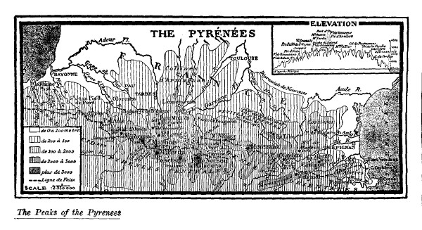
For long the Canigou was supposed to be the loftiest peak of the Pyrenees, but the Pic du Midi exceeds it by a hundred metres. However, this well proportioned, isolated mass looks more pretentious than it really is, standing, as it does, quite away from the main chain. From its peak Marseilles can be seen — by a Marseillais, who will also fancy that he can hear the turmoil of the Canebière and detect the odour of the saffron in his beloved bouillabaise. At any rate one can certainly see as much of the earth's surface spread out before him here as from any other spot of which he has recollection. The Pyrénées-Occidentales abound in more numerous and better defined mountains than the more easterly portion. Here are the famous Monts Maudits, with the Pic de Nethou, the highest of the Pyrenees (three thousand four hundred and four metres), with a summit plateau or belvedere perhaps twenty metres in length by five in width. The Vignemal (three thousand two hundred and ninety-eight metres) is the highest peak wholly on French soil and dominates the famous col, or pass, known as the Brèche de Roland. The Pic du Midi, back of Bigorre, is justly the best known of all the crests of the Pyrenees. Its height is two thousand eight hundred and seventy-seven metres, and it is worthy of a special study, and a book all to itself. The observatory recently, established here is one of the chefs-d'oeuvre of science. The astronomical, climatological and geographical importance of this prominent peak was already marked out on the maps of the sixteenth and seventeenth centuries, and its glory has been often sung in verse by Guillaume Saluste, Sire du Bartas, gentilhomme Gascon; and by Bernard Palissy, better known as a potter than as a poet. 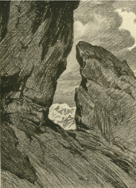 BRÈCHE DE ROLAND Towards the Gulf of Gascony the Pyrenees send out their ramifications in much gentler slopes than on the Mediterranean side. Forests and pastures are more profuse and luxuriant, but the peaks are still of granite, as they mostly are throughout the range. Grouped along the flanks of the river Bidassoa this section of the chain is known to geographers as the "Montagnes du pays Basque." At the foot of these Basque Mountains passes the lowest level route between France and Spain, — that followed by the railway and the "Route Internationale, Paris-Madrid." This easy and commodious passage of the Pyrenees has ever been the theatre of the chief struggles between the peoples of the Spanish peninsula and France. At Ronçevaux the rearguard of the army of Charlemagne — "his paladins and peers" — were destroyed in 778, and it was here that the French and Spanish fought in 1794 and 1813. The French slopes of the Pyrenees belong almost wholly to the basin or watershed of the Garonne, one of the four great waterways of France, the other three being the Loire, the Seine and the Rhône. In the upper valley of the Garonne is the Plateau de Lannemazan. It lies in reality between the Garonne and the Adour. The Adour on the west and the Tech on the east, with their tributaries, play an important part in draining off the waters from the mountain sources, but they are entirely overshadowed by the Garonne, which, rising in Spain, in the Val d'Aran, flows six hundred and five kilometres before reaching salt water below Bordeaux, through its estuary the Gironde. Nearly five hundred kilometres of this length are navigable, and the economic value of this river to Agen, Montauban and Toulouse is very great. Between the Adour and the Gironde lies that weird morass-like region of the Landes, once peopled only by sheep-herders on stilts and by charcoal-burners, but now producing a quantity of resin and pine which is making the whole region prosperous and content. The source of the Garonne is at an altitude of nearly two thousand metres, and is virtually a cascade. Another tiny source, known as the Garonne-Oriental, swells the flood of the parent stream by flowing into it just below St. Gaudens, the nearest "big town" of France to the Spanish frontier. The Ariège is the only really important tributary entering the Garonne from the region of the Pyrenees. Its length is a hundred and fifty-seven kilometres, and its source is on the Pic Nègre, at an altitude of two thousand metres, three kilometres from the frontier, but on French soil. It waters two important cities of the Comté de Foix, the capital Foix and Pamiers. On the west, the chain of the Pyrenees slopes gently down to the great bight, known so sadly to travellers by sea as the Bay of Biscay. From the mouth of the Gironde southward it is further designated as the Golfe de Gascogne. There is no perceptible indentation of the coast line to indicate this, but its waters bathe the sand dunes of the Landes, the Basque coasts, and the extreme northeastern boundary of Spain. The shore-line is straight, uniformly monotonous and inhospitable, the great waves which roll in from the Atlantic beating up a soapy surf and long dikes of sand in weird, unlovely contours. For two hundred and forty kilometres, all along the shore-line of the Gironde and the Landes, this is applicable, the only relief being the basin of Archachon (Bordeaux' own special watering-place), the port of Bayonne, — at the mouth of the Adour, — the delightful rocky picturesqueness immediately around Biarritz, and Saint-Jean-de-Luz and its harbour, and the estuary of the Bidassoa, that epoch-making river which, with the crest of the Pyrenees, marks the Franco-Espagnol frontier. The French coast line at the easterly termination of the Pyrenees possesses an entirely different aspect from that of the west. Practically there is no tide in the Mediterranean, and the gateway between France and Spain through the eastern Pyrenees is less gracious than that on the west. The Pyrénées-Orientales come plump down to the blue waters of the great inland sea just north of Cap Créus with little or no intimation of a slope. The frontier commences at Cap Cerbère, and at Port Vendres (the Portus-Veneris of the ancients) one finds one of the principal Mediterranean sea ports of France, and the nearest to the great French possessions in Africa. On Cap Créus in Spain, and on Cap Bear in France, at an elevation of something over two hundred metres, are two remarkable lighthouses whose rays carry a distance of over forty kilometres seaward. The étangs, Saint Nazaire and Leucate, cut the coast line here, and three tiny rivers, whose sources are high up in the mountain valleys of the Tech, the Tet and the Aglay, flow into the sea before Cap Leucate, the boundary between old Languedoc and the Comté de Roussillon. Off-shore is the tempestuous Golfe des Lions, where the lion banners of the Arlesien ships floated in days gone by. The Aude, the Orb and the Hérault mingle their waters with the Mediterranean here, and on the Montagne d'Agde rises another of those remarkable French lighthouses, this one throwing its light a matter of forty-five kilometres seawards. With Perpignan, Narbonne, Béziers and Agde behind, one draws slowly out from under the shadow of the Pyrenees until the soil flattens out into a powdery, dusty plain, with here and there a pond, or great bay, of soft, brackish water, whose principal value lies in its fecundity at producing mosquitoes. Aigues-Mortes cradles itself on the shores of one of these great inlets of the Mediterranean, and Saintes Maries on another. Little gulfs, canals, dwarf seaside pines, cypresses, olive trees and vineyards are the chief characteristics of the landscape, while inland the surface of the soil rolls away in gentle billows towards Nîmes, Montpellier and St. Giles, with the flat plain of the Camargue lying between. Since the Christian era began, it is assumed that this coast line' between the Pyrenees and the Rhône has advanced a matter of fourteen kilometres seaward, and since Aigues-Mortes, which now lies far inland, is known to be the port from which the sainted Louis set out on his Crusade, there is no gainsaying the statement. The immediate region surrounding Aigues-Mortes is a most fascinating one to visit, but would be a terrible place in which to be obliged to spend a life-time. Between Roussillon and Spain there are fifteen passes by which one may cross the chain of the Pyrenees, though indeed two only are practicable for wheeled traffic. The
Col de Perthus is the chief one, and is traversed by the ancient
"Route Royale" from Paris to Barcelona. There is a town by
the same name, with a population of five hundred and a really good
hotel. It's worth making the journey here just to see how a dull
French village can sleep its time away. The passage is defended by
the fine Fortress de Bellegarde. It was on the Col de Perthus that
Pompey erected the famous "trophy," surmounted by his
statue bearing the following legend:
Twenty years after, Caesar erected another tablet beside the former. No trace of either remains to-day, and there are only frontier boundary stones marking the territorial limits of France and Spain, which replace those torn down in the Revolution. 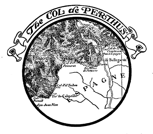 THE COL DE PERTHUS Proceeding by the coast line, a difficult road into Spain lies by the Col de Banyuls, just where the Pyrenees plunge beneath the Mediterranean, a mere shelf of a road. The cirques, or great amphitheatres of mountains, are a characteristic of the Pyrenees, and the Cirque de Gavarnie is the king of them all. It represents, very nearly, a sheer perpendicular wall rising to a height of five hundred metres, and three thousand five hundred metres in circumference. Perpetual snow is an accompaniment of some of its gorges and neighbouring peaks, and twelve cascades tumble down its rock walls at various points. There is nothing quite so impressive in the world — outside Yosemite or the Yellowstone. Gavarnie, its cirque and its village, is the natural wonder of the Pyrenees. Said Victor Hugo: "Grand nom, petit village." To explore the Cirque de Gavarnie is a passion with many; when you get in this state of mind you become what the touring Frenchman knows as a "gavarniste," as an Alpine climber becomes an "alpiniste." As for the climate of the Pyrenees, it is, for a mountain region, soft and mild; not so mild as that of the French Riviera perhaps, nor of Barcelona, nor San Sebastian in Spain, but on the whole not cold, and certainly more humid than in the Alpes-Maritimes, on the Côte d'Azur. Generally blowing from the northwest in winter, the wind accumulates great masses of cloud in the bight of the Golfe de Gascogne and sweeps them up against the barrier of the Pyrenees, there to be held in suspension until an exceedingly stiff wind blows them away or the sun burns them off. The French Riviera is cursed with the mistral, but it has the blessing of almost continual sunshine, while in the Pyrénées-Occidentales the wind is less strong as it comes only from the sea in the northwest, instead of from the north by the Rhône valley, and the "disagreeable months" (November, December and January) often bring damp and humid, if not frigidly cold weather with them. The rainfall is often as much as eight decimetres per annum in the Landes, one metre in the Pyrenees proper, and a metre and a half in the Basque country. The average rainfall for France is approximately eight decimetres, perhaps thirty-two inches. In the Pyrenees the temperature is, normally, neither very hot nor very cold. Perpignan is the warmest in winter. Its average is 15° Centigrade (59° F.), about that of Nice, whilst that for France is 6° Centigrade (43° F.). The climate of the Pyrenees comes within the climat Girondin, and the average for the year is 13° Centigrade. The climat-maritime is a further division, and is considerably more elevated in degree. This comes from the western and northwestern winds off the sea, which, it may be remarked, almost invariably bring rain with them. At Montauban the saying is: "Montagne claire, Bordeaux obscure, pluie à coup sur." In Gascogne: "Jamais pluie au printemps ne passe pour mauvais temps." At Bordeaux the average summer temperature is but 29° Centigrade, at Toulouse 21.5° Centigrade and Pau about the same, with a winter temperature often 4°' or 5° below zero Centigrade. The general aspect of the region of the Pyrenees is one of the most varied and agreeable in all southern France. There is a grandeur and natural character about it that has not fallen before the march of twentieth century progress, save in the "resorts," such as Biarritz or Pau; and yet the primitiveness and savagery is not so uncomfortable as to make the traveller long for the super-civilization of great capitals. It is virgin in its beauty and varied wildness, and yet it is a soft, pleasant land where even the winter snows of the mountains seem less rigorous than the snow and cold of Savoie or Switzerland. On one side is the great bulwark of the Pyrenees, and on two others the dazzling waters of the ocean, while to the north the valley of the Garonne, west of the Cevennes, is not at all a frigid, austere, frost-bound region, save only in the very coldest "snaps." The ranges of foothills in the Pyrenees divide the surface of the land into slopes and valleys every bit as charming as those of Switzerland, and yet oh! so different! And the fresh, limpid rivulets and rivers are real rivers, and not mere trickling brooks, whose colouring and transparency are the marvel of all who view. The majesty of the sea on either side, and of the mountains between, makes the very aspect of life luxurious and less hard than that in the more northerly Alpine climes, and above all the outlook on life is French, and not that money-grabbing Anglo-German-Swiss commercialism which the genuine traveller abhors. He sees less of that sort of thing here in the Pyrenees, even at Pau and Biarritz, than anywhere else in southern Europe. At Nice, Monte Carlo, Naples, Capri, along the Italian lakes, and everywhere in French, German or Italian speaking Switzerland, one must pay! pay! pay! continually, and often for nothing. Here you pay for what you get, and then not always its full value, according to standards with which you have previously become familiar. The Pyrenees form quite the ideal mountain playground of Europe. The Basses-Pyrénées, made up from the coherent masses of Navarre, the Basque country, Béarn, and a part of Chalosse and the Landes, contains a superficial area of seven hundred and sixty-three thousand nine hundred and ninety French acres. Its name comes naturally enough from the western end of the Pyrenean mountain chain. Throughout, the department is watered by innumerable streams and rivulets, whose banks and beds are as reminiscent of romanticism as any waterways extant. The Adour is one of the "picture-rivers" of the world; it joins the rustling, tumbling Nive, as it rushes down by Cambo from 'the Spanish valleys, and forms the port of Bayonne. The Gave de Pau commences in the high Pyrenees, in the wonderfully spectacular Cirque de Gavarnie, literally in a cascade falling nearly one thousand three hundred feet, perhaps the highest cascade known in the four quarters of the globe, or as the French say, "in the five parts of the world," which is more quaint if less literal. The Gave d'Oloron has its birth in the valley of the Aspe, and is a tributary of the Gave de Pau. It is what one might call pretty, but has little suggestion of the scenic splendour of the latter. The Bidassoa is one of the world's historic rivers. It forms the Atlantic frontier between France and Spain, and was the scene of Wellington's celebrated "Passage of the Bidassoa" in 1813, also of a still more famous historical event which took place centuries before on the Ile des Faisans. The Nivelle is a tiny stream which comes to light on Spanish soil, over the crest of the Pyrenees, and flows rapidly down to the sea at Saint-Jean-de-Luz, on the shores of the Gulf of Gascony. The Ministry for the Interior in France classes all these chief rivers as flottable for certain classes of boats and barges through a portion of their length, and each of them as navigable for a few leagues from the sea. Four great "Routes Nationales" cross the Basses-Pyrénées. They are the legitimate successors of the "Routes Royales" of monarchial days. The "Route Royale de Paris à Madrid, par Vittoria et Burgos," the very same over which Charles Quint travelled to Paris, via Amboise, as the guest of François Premier, passes via Bayonne and Saint-Jean-de-Luz. It is a veritable historic highway throughout every league of its length. The climate of the Basses-Pyrénées is by no means as warm as its latitude would seem to bespeak, the snow-capped Pyrenees keeping the temperature somewhat low. Pau and Luchon in the interior (as well as Bayonne and Biarritz on the coast) seem, curiously enough, to be somewhat milder than the open country between. The Pyrenees, though less overrun and less exploited than the Alps, are not an unknown world to be ventured into only by heroes and adventurers. They are what the French call a "new world" lively in aspect, infinitely varied, and as yet quite unspoiled, take them as a whole. This is a fact which makes the historical monuments and souvenirs of the region the more appealing in interest, particularly to one who has "done" the conventionally overrun resorts of the Tyrol, Egypt or Norway; and the country here is far more accessible. Furthermore the comforts of modern travel, as regards palace hotels and sleeping cars, if less highly developed, are more, to be remarked. One lives bountifully throughout the whole of the French slopes of the Pyrenees, from a table well supplied with many exotic articles of food such as truffles, and salaisons of all sorts, fresh mountain lake trout, and those delightful crouchades and cassoulets, which in the more populous centres are only occasional, expensive luxuries. Both the valleys and the mountains are equally charming and characteristic. The lowlanders and the mountaineers are two different species of man, but they both join hands in the admiration of, and devotion to their beloved country. The soft, sloping valleys and the plains below, in the great watersheds of the Garonne, the Aude, the Nive, or the Adour, tell one story, and the terre debout, as the French geographers call the mountains, quite another. The contrast and juxtaposition of these two topographical aspects, the varying manners and customs of the peoples, and the picturesque framing given to the châteaux and historic sites make an undeniably appealing ensemble which the writer thinks is not equalled elsewhere in travelled Europe. One of the chief characteristics of the chain of the Pyrenees is that it possesses numerous passages or passes at very considerable elevations, being outranked by surrounding peaks usually to the extent of a thousand metres only. These passes are not always practicable for wheeled traffic to be sure, but still they form a series of exits and entrances from and into Spain which are open to the dwellers in the high valleys of either country on foot or on donkey back. They are distinguished by various prefixes such as puerto, collada, passo, hourque, hourquette, brèche, port, col, and passage, but one and all answer more or less specifically to the name of a mountain pass. The expression of "il y a des Pyrénées," has been paraphrased in latter days as "il n'y a plus de Pyrénées." A Spanish aeronaut has recently crossed the crest of the range in a balloon, from Pau to Grenada — seven hundred and thirty kilometres as the birds fly. This intrepid sportsman, in his balloon "El Cierzo," crossed the divide in the dead of night, at an elevation varying between two thousand three hundred and two thousand nine hundred metres, somewhere between the Pic d'Anie and the Pic du Midi d'Ossau. In these days when automobiles beat express trains, and motor-boats beat steamships for speed, this crossing of the Pyrenees by balloon stands unique in the annals of sport. The crossing of the Pyrenees has already resolved itself into a momentous economic question. Half a dozen roads fit for carriage traffic, and two gateways by which pass the railways of the east and west coasts, are the sole practicable means of communication between France and Spain. The chain of the Pyrenees from west to eat presents nearly a uniform height; its simplicity and uniformity is remarkable. It is a veritable wall. To-day the Parisian journals are all printing scare-heads, reading, "Plus de Pyrénées" and announcing railway projects which will bring Paris and Madrid within twenty hours of each other, and Paris and Algiers within forty. New tunnels, or ports, to the extent of five in place of two, are to be opened, and if balloons or air-ships don't come to supersede railways there will be a net-work of iron rails throughout the upper valleys of the Pyrenees as there are in Switzerland. The ville d'eaux, or watering-places, of the Pyrenees date from prehistoric times. At Ax-les-Thermes there has recently been discovered a tank buried under three metres of alluvial soil, and dating from the bronze age. Old maps of these parts show that the baths and waters of the region were widely known in mediæval times. It was not, however, until the reign of Louis XV that the "stations" took on that popular development brought about by the sovereigns and their courts who frequented them. Not all of these can be indicated or described here but the accompanying map indicates them and their locations plainly enough. 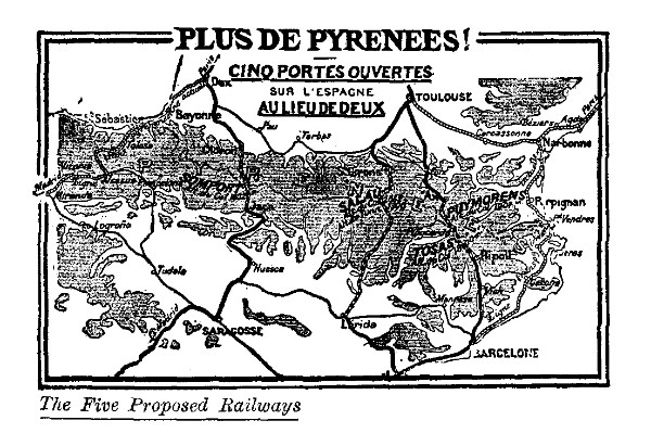
Nearly every malady, real or imaginary (and there have been many imaginary ones here, that have undergone a cure), can be benefited by the waters of the Pyrenees. Only a specialist could prescribe though. 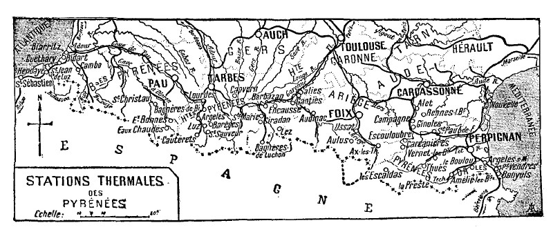
In point of popularity as resorts the baths and springs of the Pyrenees rank about as follows: Eaux-Bonnes, Eaux-Chaudes, Cauterets, St. Sauveur, Barèges, Bagnères de Bigorre, Luchon, Salies dé Béarn, Ussat, Axles-Thermes, Vernet and Amélie les Bains. Whatever the efficacy of their waters may be, one and all may be classed as resorts where "all the attractions" — as the posters announce — of similar places elsewhere may be found, — great and expensive hotels, tea shops, theatres, golf, tennis and "the gaine." If the waters don't cure, one is sure to have been amused, if not edified. The watering-places of the Pyrenees may not possess establishments or bath houses as grand or notorious as those of Vichy, Aix, or Homburg, and their attendant amusements of sport and high stakes and cards may not be the chief reason they are patronized, but all the same they are very popular little resorts, with as charming settings and delightful surroundings as any known. At Eaux-Bonnes there are four famous springs, and at Eaux-Chaudes are six of diverse temperatures, all of them exceedingly efficacious "cures" for rheumatism. At Cambo — a new-found retreat for French painters and literary folk — are two sources, one sulphurous and the other ferruginous. Mostly the waters of Cambo are drunk; for bathing purposes they are always heated. Napoleon first set the pace at Cambo, but its fame was a long while becoming widespread. In 1808 the emperor proposed to erect a military hospital here, and one hundred and fifty thousand francs were actually appropriated for it, but the fall of the Empire ended that hope as it did many others. In the commune of Salies is a source, a fontaine, which gives a considerable supply of salt to be obtained through evaporation; also in the mountains neighbouring upon Saint-Jean-Pied-de-Port, and in the Arrondissement of Mauléon, are still other springs from which the extraction of salt is a profitable industry. In the borders of the blue Gave de Pau, in full view of the extended horizon on one side and the lowland plain on the other, one appreciates the characteristics of the Pyrenees at their very best. One recalls the gentle hills and vales of the Ile de France, the rude, granite slopes of Bretagne, the sublime peaks of the Savoian Alps, and all the rest of the topographic tableau of "la belle France," but nothing seen before — nor to be seen later — excels the Pyrenees region for infinite variety. It is truly remarkable, from the grandeur of its sky-line to the winsomeness and softness of its valleys; peopled everywhere (always excepting the alien importations of the resorts) with a reminiscent civilization of the past, with little or no care for the super-refinements of more populous and progressve regions. The Pyrenees, as a whole, are still unspoiled for the serious-minded traveller. This is more than can be said of the Swiss Alps, the French Riviera, the German Rhine, or the byways of merry England. |
 Click the book image to turn
to the next Chapter.
Click the book image to turn
to the next Chapter.