 |
 |
 |
 |
| Kellscraft
Studio Home Page |
Wallpaper
Images for your Computer |
Nekrassoff Informational Pages |
Web
Text-ures© Free Books on-line |
|
MY
FIRST SUMMER IN THE SIERRA
BY
 THE YOSEMITE FALLS, YOSEMITE
NATIONAL PARK
BOSTON AND NEW YORK HOUGHTON MIFFLIN COMPANY MDCCCCXVI COPYRIGHT, 1911, BY JOHN MUIR COPYRIGHT, 1916, BY HOUGHTON MIFFLIN COMPANY EDITION LIMITED TO SEVEN HUNDRED AND FIFTY COPIES THIS IS NUMBER 231 TO THE SIERRA CLUB OF CALIFORNIA FAITHFUL DEFENDER OF THE PEOPLE'S PLAYGROUNDS CONTENTS
II. IN CAMP ON THE
NORTH
FORK OF THE MERCED
III. A BREAD FAMINE IV. TO THE HIGH MOUNTAINS V. THE YOSEMITE VI. MOUNT HUFFMAN AND LAKE TENAYA VII. A STRANGE EXPERIENCE VIII. THE MONO TRAIL IX. BLOODY CANON AND MONO LAKE X. THE TUOLUMNE CAMP XI. BACK TO THE LOWLANDS ILLUSTRATIONS THE YOSEMITE FALLS, YOSEMITE
NATIONAL PARK
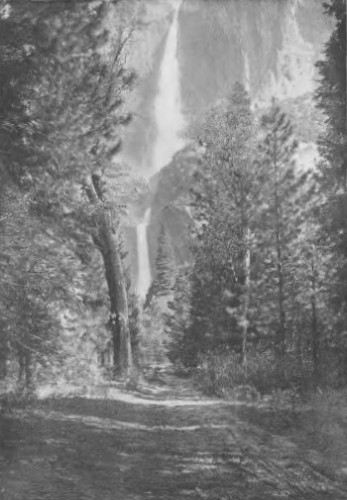
The total height of the three falls is 2600 feet. The upper fall is about 1600 feet, and the lower about 400 feet. Mr. Muir was probably the only man who ever looked down into the heart of the fall from the narrow ledge of rocks near the top. From a photograph by Charles S. Olcott SHEEP IN THE MOUNTAINS
Since the establishment of the Yosemite National Park the pasturing of sheep has not been allowed within its boundaries, and as a result the grasses and wild flowers have recovered very much of their former luxuriance. The flock of sheep here photographed were feeding near Alger Lake on the slope of Blacktop Mountain, at an altitude of about 10,000 feet and just beyond the eastern boundary of the Park. From a photograph by Herbert W. Gleason A SILVER FIR, OR RED FIR (Abies
magnifica).
This tree was found in an extensive forest of red fir above the Middle Fork of King's River. It was estimated to be about 250 feet high. Mr. Muir, on being shown the photograph, remarked that it was one of the finest and most mature specimens of the red fir that he had ever seen. From a photograph by Herbert W. Gleason THE NORTH AND SOUTH DOMES
The great rock on the right is the South Dome, commonly called the Half-Dome, according to Mr. Muir "the most beautiful and most sublime of all the Yosemite rocks." The one on the left is the North Dome, while in the center is the Washington Column. From a photograph by Charles S. Olcott THE VERNAL FALLS, YOSEMITE
NATIONAL PARK.
From a photograph
by Charles S. Olcott THE HAPPY ISLES, YOSEMITE
NATIONAL PARK
This is the main stream of the Merced River after passing over the Nevada and Vernal Falls and receiving the Illilouette tributary. From a photograph by Charles S. Olcott CATHEDRAL PEAK
This view was taken from a point on the Sunrise Trail just south of the Peak, on a day when the "cloud mountains" so inspiring to Mr. Muir were much in evidence. From a photograph by Herbert W. Gleason THE THREE BROTHERS, YOSEMITE
NATIONAL PARK
The highest rock, called Eagle Point, is 7900 feet above the sea, and 3900 feet above the floor of the valley. From a photograph by Charles S. Olcott MAP OF THE YOSEMITE NATIONAL
PARK
From the United
States Geological Survey FROM SKETCHES MADE BY THE
AUTHOR IN 1869
ON SECOND BENCH. EDGE OF THE MAIN FOREST BELT, ABOVE COULTERVILLE, NEAR GREELEY'S MILL CAMP, NORTH FORK OF THE MERCED MOUNTAIN LIVE OAK (Quercus chrysdepis), EIGHT FEET IN DIAMETER SUGAR PINE DOUGLAS SQUIRREL OBSERVING BROTHER MAN DIVIDE BETWEEN THE TUOLUMNE AND THE MERCED, TRACK OF SINGING DANCING GRASSHOPPER IN THE ABIES MAGNIFICA (MOUNT CLARK, TOP OF SOUTH ILLUSTRATING GROWTH OF NEW PINE FROM BRANCH APPROACH OF DOME CREEK TO YOSEMITE JUNIPERS IN TENATA CANON VIEW OF TENATA LAKE SHOWING CATHEDRAL PEAK ONE OF THE TRIBUTARY FOUNTAINS OF THE TUOLUMNE CANON WATERS, ON THE NORTH SIDE OF THE HOFFMAN RANGE GLACIER MEADOW, ON THE HEADWATERS OF THE TUOLUMNE, 9500 FEET ABOVE THE SEA MONO LAKE AND VOLCANIC CONES, LOOKING SOUTH HIGHEST MONO VOLCANIC CONES (NEAR VIEW) ONE OF THE HIGHEST MOUNT RITTER FOUNTAINS GLACIER MEADOW STREWN WITH MORAINE BOULDERS, 10,000 FEET ABOVE THE SEA (NEAR MOUNT DANA) FRONT OF CATHEDRAL PEAK VIEW OF UPPER TUOLUMNE VALLEY |