Web
and Book design, Web
and Book design, Copyright, Kellscraft Studio 1999-2003 (Return to Web Text-ures) |
Click Here to return to Inca Lands Content Page Click Here to return to previous chapter |
 (HOME) |
| Web
and Book design, Copyright, Kellscraft Studio 1999-2003 (Return to Web Text-ures) |
Click Here to return to Inca Lands Content Page Click Here to return to previous chapter |
(HOME) |
|
CHAPTER XVII MACHU PICCHU IT was in July, 1911,
that we
first entered that
marvelous canyon of the Urubamba, where the river escapes from the cold
regions
near Cuzco by tearing its way through gigantic mountains of granite.
From
Torontoy to Colpani the road runs through a land of matchless charm. It
has the
majestic grandeur of the Canadian Rockies, as well as the startling
beauty of
the Nuuanu Pali near Honolulu, and the enchanting vistas of the Koolau
Ditch
Trail on Maui. In the variety of its charms and the power of its spell,
I know
of no place in the world which can compare with it. Not only has it
great snow
peaks looming above the clouds more than two miles overhead; gigantic
precipices
of many-colored granite rising sheer for thousands of feet above the
foaming,
glistening, roaring rapids; it has also, in striking contrast, orchids
and tree
ferns, the delectable beauty of luxurious vegetation, and the
mysterious
witchery of the jungle. One is drawn irresistibly onward by
ever-recurring
surprises through a deep, winding gorge, turning and twisting past
overhanging
cliffs of incredible height. Above all, there is the fascination of
finding
here and there under the swaying vines, or perched on top of a beetling
crag,
the rugged masonry of a bygone race; and of trying to understand the
bewildering romance of the ancient builders who ages ago sought refuge
in a
region which appears to have been expressly designed by Nature as a
sanctuary
for the oppressed, a place where they might fearlessly and patiently
give
expression to their passion for walls of enduring beauty. Space forbids
any
attempt to describe in detail the constantly changing panorama, the
rank
tropical foliage, the countless terraces, the towering cliffs, the
glaciers
peeping out between the clouds. We had camped at a
place near
the river, called
Mandor Pampa. Melchor Arteaga, proprietor of the neighboring farm, had
told us
of ruins at Machu Picchu, as was related in Chapter X. The morning of July
24th dawned
in a cold drizzle.
Arteaga shivered and seemed inclined to stay in his hut. I offered to
pay him
well if he would show me the ruins. He demurred and said it was too
hard a
climb for such a wet day. When he found that we were willing to pay him
a sol,
three or four times the ordinary daily wage in this vicinity, he
finally agreed
to guide us to the ruins. No one supposed that they would be
particularly
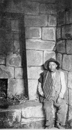
interesting. Accompanied by Sergeant Carrasco I left camp at ten
o’clock and
went some distance upstream. On the road we passed a venomous snake
which
recently had been killed. This region has an unpleasant notoriety for
being the
favorite haunt of “vipers.” The lance-headed or yellow viper, commonly
known as
the fer-de-lance, a very venomous serpent capable of making
considerable
springs when in pursuit of its prey, is common hereabouts. Later two of
our
mules died from snake-bite. After a walk of three
quarters
of an hour the guide
left the main road and plunged down through the jungle to the bank of
the
river. Here there was a primitive “bridge” which crossed the roaring
rapids at
its narrowest part, where the stream was forced to flow between two
great
boulders. The bridge was made of half a dozen very slender logs, some
of which
were not long enough to span the distance between the boulders. They
had been
spliced and lashed together with vines. Arteaga and Carrasco took off
their
shoes and crept gingerly across, using their somewhat prehensile toes
to keep
from slipping. It was obvious that no one could have lived for an
instant in
the rapids, but would immediately have been dashed to pieces against
granite
boulders. I am frank to confess that I got down on hands and knees and
crawled
across, six inches at a time. Even after we reached the other side I
could not
help wondering what would happen to the “bridge” if a particularly
heavy shower
should fall in the valley above. A light rain had fallen during the
night. The
river had risen so that the bridge was already threatened by the
foaming
rapids. It would not take much more rain to wash away the bridge
entirely. If
this should happen during the day it might be very awkward. As a matter
of
fact, it did happen a few days later and the next explorers to attempt
to cross
the river at this point found only one slender log remaining. Leaving the stream,
we
struggled up the bank through
a dense jungle, and in a few minutes reached the bottom of a
precipitous slope.
For an hour and twenty
minutes we had a
hard climb. A good part of the distance we went on all fours, sometimes
hanging
on by the tips of our fingers. Here and there, a primitive ladder made
from the
roughly hewn trunk of a small tree was placed in such a way as to help
one over
what might otherwise have proved to be an impassable cliff. In another
place
the slope was covered with slippery grass where it was hard to find
either
handholds or footholds. The guide said that there were lots of snakes
here. The
humidity was great, the heat was excessive, and we were not in training. Shortly after noon we
reached a
little grass-covered
hut where several good-natured Indians, pleasantly surprised at our
unexpected
arrival, welcomed us with dripping gourds full of cool, delicious
water. Then
they set before us a few cooked sweet potatoes, called here cumara,
a
Quichua word identical with the Polynesian kumala,
as has been pointed
out by Mr. Cook. Apart from the
wonderful view
of the canyon, all we
could see from our cool shelter was a couple of small grass huts and a
few
ancient stone-faced terraces. Two pleasant Indian farmers, Richarte and
Alvarez, had chosen this eagle’s nest for their home. They said they
had found
plenty of terraces here on which to grow their crops and they were
usually free
from undesirable visitors. They did not speak Spanish, but through
Sergeant
Carrasco I learned that there were more ruins “a little farther along.”
In this
country one never can tell whether such a report is worthy of credence.
“He may
have been lying” is a good footnote to affix to all hearsay evidence.
Accordingly, I was not unduly excited, nor in a great hurry to move.
The heat
was still great, the water from the Indian’s spring was cool and
delicious, and
the rustic wooden bench, hospitably covered immediately after my
arrival with a
soft, woolen poncho, seemed most comfortable. Furthermore, the view was
simply
enchanting. Tremendous green precipices fell away to the white rapids
of the
Urubamba below. Immediately in front, on the north side of the valley,
was a
great granite cliff rising 2000 feet sheer. To the left was the
solitary peak
of Huayna Picchu, surrounded by seemingly inaccessible precipices. On
all sides
were rocky cliffs. Beyond them cloud-capped mountains rose thousands of
feet
above us. The Indians said
there were two
paths to the outside
world. Of one we had already had a taste; the other, they said, was
more
difficult — a perilous path down the face of a rocky precipice on the
other
side of the ridge. It was their only means of egress in the wet season,
when
the bridge over which we had come could not be maintained. I was not
surprised
to learn that they went away from home only “about once a month.” Richarte told us that
they had
been living here four
years. It seems probable that, owing to its inaccessibility, the canyon
had
been unoccupied for several centuries, but with the completion of the
new
government road settlers began once more to occupy this region. In time
somebody clambered up the precipices and found on the slopes of Machu
Picchu,
at an elevation of 9000 feet above the sea, an abundance of rich soil
conveniently situated on artificial terraces, in a fine climate. Here
the
Indians had finally cleared off some ruins, burned over a few terraces,
and
planted crops of maize, sweet and white potatoes, sugar cane, beans,
peppers,
tree tomatoes, and gooseberries. At first they appropriated some of the
ancient
houses and replaced the roofs of wood and thatch. They found, however,
that
there were neither springs nor wells near the ancient buildings. An
ancient
aqueduct which had once brought a tiny stream to the citadel had long
since
disappeared beneath the forest, filled with earth washed from the upper
terraces. So, abandoning the shelter of the ruins, the Indians were now
enjoying the convenience of living near some springs in roughly built
thatched
huts of their own design. Without the slightest
expectation of finding
anything more interesting than the stone-faced terraces of which I
already had
a glimpse, and the ruins of two or three stone houses such as we had
encountered
at various places on the road between Ollantaytambo and Torontoy, I
finally
left the cool shade of the pleasant little hut and climbed farther up
the ridge
and around a slight promontory. Arteaga had “been here once before,”
and
decided to rest and gossip with Richarte and Alvarez in the hut. They
sent a
small boy with me as a guide. Hardly had we rounded
the
promontory when the
character of the stonework began to improve. A flight of beautifully
constructed terraces, each two hundred yards long and ten feet high,
had been
recently rescued from the jungle by the Indians, A forest of large
trees had
been chopped down and burned over to make a clearing for agricultural
purposes.
Crossing these terraces, I entered the untouched forest beyond, and
suddenly
found myself in a maze of beautiful granite houses! They were covered
with
trees and moss and the growth of centuries, but in the dense shadow,
hiding in
bamboo thickets and tangled vines, could be seen, here and there, walls
of
white granite ashlars most carefully cut and exquisitely fitted
together.
Buildings with windows were frequent. Here at least was a “place far
from town
and conspicuous for its windows.”
Under a carved rock
the little
boy showed me a cave
beautifully lined with the finest cut stone. It was evidently intended
to be a
Royal Mausoleum. On top of this particular boulder a semicircular
building had
been constructed. The wall followed the natural curvature of the rock
and was
keyed to it by one of the finest examples of masonry I have ever seen.
This
beautiful wall, made of carefully matched ashlars of pure white
granite,
especially selected for its fine grain, was the work of a master
artist. The
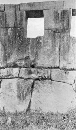
interior surface of the wall was broken by niches and square
stone-pegs. The
exterior surface was perfectly simple and unadorned. The lower courses,
of
particularly large ashlars, gave it a look of solidity. The upper
courses,
diminishing in size toward the top, lent grace and delicacy to the
structure.
The flowing lines, the symmetrical arrangement of the ashlars, and the
gradual
gradation of the courses, combined to produce a wonderful effect,
softer and
more pleasing than that of the marble temples of the Old World. Owing
to the
absence of mortar, there are no ugly spaces between the rocks. They
might have
grown together. The elusive beauty of
this
chaste, undecorated
surface seems to me to be due to the fact that the wall was built under
the eye
of a master mason who knew not the straight edge, the plumb rule, or
the
square. He had no instruments of precision, so he had to depend on his
eye. He
had a good eye, an artistic eye, an eye for symmetry and beauty of
form. His
product received none of the harshness of mechanical and mathematical
accuracy.
The apparently rectangular blocks are not really rectangular. The
apparently
straight lines of the courses are not actually straight in the exact
sense of
that term. To my astonishment I
saw that
this wall and its
adjoining semicircular temple over the cave were as fine as the finest
stonework in the far-famed Temple of the Sun in Cuzco. Surprise
followed
surprise in bewildering succession. I climbed a marvelous great
stairway of
large granite blocks, walked along a pampa where the
Indians had a small
vegetable garden, and came into a little clearing. Here were the ruins
of two
of the finest structures I have ever seen in Peru. Not only were they
made of
selected blocks of beautifully grained white granite; their walls
contained
ashlars of Cyclopean size, ten feet in length, and higher than a man.
The sight
held me spellbound. Each building had
only three
walls and was entirely
open on the side toward the clearing. The principal temple was lined
with
exquisitely made niches, five high up at each end, and seven on the
back wall.
There were seven courses of ashlars in the end walls. Under the seven
rear
niches was a rectangular block fourteen feet long, probably a
sacrificial
altar. The building did not look as though it had ever had a roof. The
top
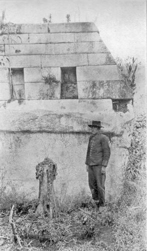
course of beautifully smooth ashlars was not intended to be covered. The other temple is
on the east
side of the pampa.
I called it the Temple of the Three Windows. Like its neighbor, it is
unique
among Inca ruins. Its eastern wall, overlooking the citadel, is a
massive stone
framework for three conspicuously large windows, obviously too large to
serve
any useful purpose, yet most beautifully made with the greatest care
and
solidity. This was clearly a ceremonial edifice of peculiar
significance.
Nowhere else in Peru, so far as I know, is there a similar structure
conspicuous
as “a masonry wall with three windows.” These ruins have no
other name
than that of the
mountain on the slopes of which they are located. Had this place been
occupied
uninterruptedly, like Cuzco and Ollantaytambo, Machu Picchu would have
retained
its ancient name, but during the centuries when it was abandoned, its
name was
lost. Examination showed that it was essentially a fortified place, a
remote
fastness protected by natural bulwarks, of which man took advantage to
create
the most impregnable stronghold in the Andes. Our subsequent
excavations and
the clearing made in 1912, to be described in a subsequent volume, has
shown
that this was the chief place in Uilcapampa.
It did not take an
expert to
realize, from the
glimpse of Machu Picchu on that rainy day in July, 1911, when Sergeant
Carrasco
and I first saw it, that here were most extraordinary and interesting
ruins.
Although the ridge had been partly cleared by the Indians for their
fields of
maize, so much of it was still underneath a thick jungle growth — some
walls
were actually supporting trees ten and twelve inches in diameter — that
it was
impossible to determine just what would be found here. As soon as I
could get
hold of Mr. Tucker, who wits assisting Mr. Hendrikson, and Mr. Lanius,
who had
gone down the Urubamba with Dr. Bowman, I asked them to make a map of
the
ruins. I knew it would be a difficult undertaking and that it was
essential for
Mr. Tucker to join me in Arequipa not later than the first of October
for the
ascent of Coropuna. With the hearty aid of Richarte and Alvarez, the
surveyors
did better than I expected. In the ten days while they were at the
ruins they
were able to secure data from which Mr. Tucker afterwards prepared a
map which
told better than could any words of mine the importance of this site
and the
necessity for further investigation. With the possible
exception of
one mining
prospector, no one in Cuzco had seen the ruins of Machu Picchu or
appreciated
their importance. No one had any realization of what an extraordinary
place lay
on top of the ridge. It had never been visited by any of the planters
of the
lower Urubamba Valley who annually passed over the road which winds
through the
canyon two thousand feet below. It seems incredible
that this
citadel, less than
three days’ journey from Cuzco, should have remained so long
undescribed by
travelers and comparatively unknown even to the Peruvians themselves.
If the conquistadores ever saw
this wonderful
place, some reference to it surely would have been made; yet nothing
can be
found which clearly refers to the ruins of Machu Picchu. Just when it
was first
seen by a Spanish-speaking person is uncertain. When the Count de
Sartiges was
at Huadquina in 1834 he was looking for ruins; yet, although so near,
he heard
of none here. From a crude scrawl on the walls of one of the finest
buildings,
we learned that the ruins were visited in 1902 by Lizarraga, lessee of
the
lands immediately below the bridge of San Miguel. This is the earliest
local
record. Yet some one must have visited Machu Picchu long before that;
because
in 1875, as has been said, the French explorer Charles Wiener heard in
Ollantaytambo of there being ruins at “Huaina-Picchu or Matcho-Picchu.”
He
tried to find them. That he failed was due to there being no road
through the
canyon of Torontoy and the necessity of making a wide detour through
the pass
of Panticalla and the Lucumayo Valley, a route which brought him to the
Urubamba River at the bridge of Chuquichaca, twenty-five miles below
Machu
Picchu. It was not until 1890
that the
Peruvian Government,
recognizing the needs of the enterprising planters who were opening up
the
lower valley of the Urubamba, decided to construct a mule trail along
the banks
of the river through the grand canyon to enable the much-desired coca
and aguardiente to be shipped from
Huadquina, Maranura, and Santa Ana to Cuzco more quickly and cheaply
than
formerly. This road avoids the necessity of carrying the precious
cargoes over
the dangerous snowy passes of Mt. Veronica and Mt. Salcantay, so
vividly
described by Raimondi, de Sartiges, and others. The road, however, was
very
expensive, took years to build, and still requires frequent repair. In
fact,
even to-day travel over it is often suspended for several days or weeks
at a
time, following some tremendous avalanche. Yet it was this new road
which had
led Melchor Arteaga to build his hut near the arable land at Mandor
Pampa,
where he could raise food for his family and offer rough shelter to
passing
travelers. It was this new road which brought Richarte, Alvarez, and
their
enterprising friends into this little-known region, gave them the
opportunity
of occupying the ancient terraces of Machu Picchu, which had lain
fallow for
centuries, encouraged them to keep open a passable trail over the
precipices,
and made it feasible for us to reach the ruins. It was this new road
which
offered us in 1911 a virgin field
between Ollantaytambo and Huadquina and enabled us to learn that the
Incas,
or their predecessors, had once lived here in the remote fastnesses of
the
Andes, and had left stone witnesses of the magnificence and beauty of
their
ancient civilization, more interesting and extensive than any which
have been
found since the days of the Spanish Conquest of Peru.
Click
 here to continue to the next chapter of Inca Lands
|