 Web
and Book design, Web
and Book design, Copyright, Kellscraft Studio 1999-2003 (Return to Web Text-ures) |
Click Here to return to Inca Lands Content Page Click Here to return to previous chapter |
 (HOME) |
| Web
and Book design, Copyright, Kellscraft Studio 1999-2003 (Return to Web Text-ures) |
Click Here to return to Inca Lands Content Page Click Here to return to previous chapter |
(HOME) |
|
CHAPTER
XI THE SEARCH CONTINUED MACHU PICCHU is on
the
border-line between the
temperate zone and the tropics. Camping near the bridge of San Miguel,
below
the ruins, both Mr. Heller and Mr. Cook found interesting evidences of
this
fact in the flora and fauna. From the point of view of historical
geography,
Mr. Cook’s most important discovery was the presence here of huilca, a
tree
which does not grow in cold climates. The Quichua dictionaries tell us huilca is a “medicine, a purgative.” An
infusion made from the seeds of the tree is used as an enema. I am
indebted to
Mr. Cook for calling my attention to two articles by Mr. W. E. Safford
in which
it is also shown that from seeds of the huilca
a powder is prepared, sometimes called cohoba.
This powder, says Mr. Safford, is a narcotic snuff
“inhaled through the
nostrils by means of a bifurcated tube.” “All writers unite in
declaring that
it induced a kind of intoxication or hypnotic state, accompanied by
visions
which were regarded by the natives as supernatural. While under its
influence
the necromancers, or priests, were supposed to hold communication with
unseen
powers, and their incoherent mutterings were regarded as prophecies or
revelations of hidden things. In treating the sick the physicians made
use of
it to discover the cause of the malady or the person or spirit by whom
the
patient was bewitched.” Mr. Safford quotes Las Casas as saying: “It was
an
interesting spectacle to witness how they took it and what they spake.
The
chief began the ceremony and while he was engaged all remained
silent.... When
he had snuffed up the powder through his nostrils, he remained silent
for a
while with his head inclined to one side and his arms placed on his
knees. Then
he raised his face heavenward, uttering certain words which must have
been his
prayer to the true God, or to him whom he held as God; after which all
responded,
almost as we do when we say amen; and this they did with a loud voice
or sound.
Then they gave thanks and said to him certain complimentary things,
entreating
his benevolence and begging him to reveal to them what he had seen. He
described to them his vision, saying that the Cemi [spirits] had spoken
to him
and had predicted good times or the contrary, or that children were to
be born,
or to die, or that there was to be some dispute with their neighbors,
and other
things which might come to his imagination, all disturbed with that
intoxication.”1 Clearly, from the
point of view
of priests and
soothsayers, the place where huilca was first found
and used in their
incantations would be important. It is not strange to find therefore
that the
Inca name of this river was Uilca-mayu:
the “huilca river.” The pampa on
this river where the trees grew
would likely receive the name Uilca pampa. If it
became an important
city, then the surrounding region might be named Uilcapampa
after it. This seems to me to be the most probable
origin of the name of the province. Anyhow it is worth noting the fact
that
denizens of Cuzco and Ollantaytambo, coming down the river in search of
this
highly prized narcotic, must have found the first trees not far from
Machu
Picchu. Leaving the ruins of
Machu
Picchu for later
investigation, we now pushed on down the Urubamba Valley, crossed the
bridge of
San Miguel, passed the house of Señor Lizarraga, first of modern
Peruvians to
write his name on the granite walls of Machu Picchu, and came to the
sugarcane
fields of Huadquina. We had now left the temperate zone and entered the
tropics. At Huadquina we were
so
fortunate as to find that
the proprietress of the plantation, Señora Carmen Vargas, and her
children,
were spending the season here. During the rainy winter months they live
in
Cuzco, but when summer brings fine weather they come to Huadquina to
enjoy the
free-and-easy life of the country. They made us welcome, not only with
that
hospitality to passing travelers which is common to sugar estates all
over the
world, but gave us real assistance in our explorations. Señora Carmen’s
estate
covers more than two hundred square miles. Huadquina is a splendid
example of
the ancient patriarchal system. The Indians who come from other parts
of Peru
to work on the plantation enjoy perquisites and wages unknown
elsewhere. Those
whose home is on the estate regard Señora Carmen with an affectionate
reverence
which she well deserves. All are welcome to bring her their troubles.
The
system goes back to the days when the spiritual, moral, and material
welfare of
the Indians was entrusted in encomieda
to the lords of the repartimiento
or
allotted territory. 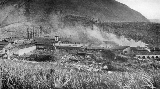 HUADQUIÑA Huadquina once
belonged to the
Jesuits. They planted
the first sugar cane and established the mill. After their expulsion
from the
Spanish colonies at the end of the eighteenth century, Huadquina was
bought by
a Peruvian. It was first described in geographical literature by the
Count de
Sartiges, who stayed here for several weeks in 1834 when on his way to
Choqquequirau. He says that the owner of Huadquina “is perhaps the only
landed
proprietor in the entire world who possesses on his estates all the
products of
the four parts of the globe. In the different regions of his domain he
has
wool, hides, horsehair, potatoes, wheat, corn, sugar, coffee,
chocolate, coca, many
mines of silver-bearing lead, and
placers of gold.” Truly a royal principality. Incidentally it is
interesting
to note that although
Sartiges was an enthusiastic explorer, eager to visit undescribed Inca
ruins,
he makes no mention what-ever of Machu Picchu. Yet from Huadquina one
can reach
Machu Picchu on foot in half a day without crossing the Urubamba River.
Apparently the ruins were unknown to his hosts in 1834. They were
equally unknown
to our kind hosts in 1911. They scarcely believed the story I told them
of the
beauty and extent of the Inca edifices.2 When my
photographs were
developed, however, and they saw with their own eyes the marvelous
stonework of
the principal temples, Señora Carmen and her family were struck dumb
with
wonder and astonishment. They could not understand how it was possible
that
they should have passed so close to Machu Picchu every year of their
lives
since the river road was opened without knowing what was there. They
had seen a
single little building on the crest of the ridge, but supposed that it
was an
isolated tower of no great interest or importance. Their neighbor,
Lizarraga,
near the bridge of San Miguel, had reported the presence of the ruins
which he first
visited in 1904, but, like our friends in Cuzco, they had paid little
attention
to his stories. We were soon to have a demonstration of the causes of
such
skepticism. Our new friends read
with
interest my copy of those
paragraphs of Calancha’s “Chronicle” which referred to the location of
the last
Inca capital. Learning that we were anxious to discover Uiticos, a
place of
which they had never heard, they ordered the most intelligent tenants
on the
estate to come in and be questioned. The best informed of all was a
sturdy
mestizo, a trusted foreman, who said that in a little valley called
Ccllumayu,
a few hours’ journey down the Urubamba, there were “important ruins”
which had
been seen by some of Señora Carmen’s Indians. Even more interesting and
thrilling
was his statement that on a ridge up the Salcantay Valley was a place
called
Yurak Rumi (yurak = “white”; rumi =
“stone”) where some very
interesting ruins had been found by his workmen when cutting trees for
firewood. We all became excited over this, for among the paragraphs
which I had
copied from Calancha’s “Chronicle”
was
the statement that “close to Uiticos” is the “white stone of the
aforesaid
house of the Sun which is called Yurak Rumi.” Our hosts assured us that
this
must be the place, since no one hereabouts had ever heard of any other
Yurak
Rumi. The foreman, on being closely questioned, said that he had seen
the ruins
once or twice, that he had also been up the Urubamba Valley and seen
the great
ruins at Ollantaytambo, and that those which he had seen at Yurak Rumi
were “as
good as those at Ollantaytambo.” Here was a definite statement made by
an
eyewitness. Apparently we were about to see that interesting rock where
the
last Incas worshiped. However, the foreman said that the trail thither
was at
present impassable, although a small gang of Indians could open it in
less than
a week. Our hosts, excited by the pictures we had shown them of Machu
Picchu,
and now believing that even finer ruins might be found on their own
property,
immediately gave orders to have the path to Yurak Rumi cleared for our
benefit. While this was being
done,
Señora Carmen’s son, the
manager of the plantation, offered to accompany us himself to
Ccllumayu, where
other “important ruins” had been found, which could be reached in a few
hours
without cutting any new trails. Acting on his assurance that we should
not need
tent or cots, we left our camping outfit behind and followed him to a
small
valley on the south side of the Urubamba. We found Ccllumayu to consist
of two
huts in a small clearing. Densely wooded slopes rose on all sides. The
manager
requested two of the Indian tenants to act as guides. With them, we
plunged
into the thick jungle and spent a long and fatiguing day searching in
vain for
ruins. That night the manager returned to Huadquina, but Professor
Foote and I
preferred to remain in Ccllumayu and prosecute a more vigorous search
on the
next day. We shared a little thatched hut with our Indian hosts and a
score of
fat cuys (guinea pigs), the chief
source of the Ccllumayu meat supply. The hut was built of rough wattles
which
admitted plenty of fresh air and gave us comfortable ventilation.
Primitive
little sleeping-platforms, also of wattles, constructed for the needs
of short,
stocky Indians, kept us from being overrun by inquisitive cuys,
but could hardly be called as
comfortable as our own folding
cots which we had left at Huadquina. The next day our
guides were
able to point out in
the woods a few piles of stones, the foundations of oval or circular
huts which
probably were built by some primitive savage tribe in prehistoric
times.
Nothing further could be found here of ruins, “important” or otherwise,
although we spent three days at Ccllumayu. Such was our first
disillusionment. On our return to
Huadquina, we
learned that the
trail to Yurak Rumi would be ready “in a day or two.” In the meantime
our hosts
became much interested in Professor Foote’s collection of insects. They brought an
unnamed
scorpion and informed us
that an orange orchard surrounded by high walls in a secluded place
back of the
house was “a great place for spiders.” We found that their statement
was not
exaggerated and immediately engaged in an enthusiastic spider hunt.
When these
Huadquina spiders were studied at the Harvard Museum of Comparative
Zoology,
Dr. Chamberlain found among them the representatives of four new genera
and
nineteen species hitherto unknown to science. As a reward of merit, he
gave
Professor Foote’s name to the scorpion! Finally the trail to
Yurak Rumi
was reported finished.
It was with feelings of keen anticipation that I started out with the
foreman
to see those ruins which he had just revisited and now declared were
“better
than those of Ollantaytambo.” It was to be presumed that in the pride
of
discovery he might have exaggerated their importance. Still it never
entered my
head what I was actually to find. After several hours spent in clearing
away
the dense forest growth which surrounded the walls I learned that this
Yurak
Rumi consisted of the ruins of a single little rectangular Inca
storehouse. No
effort had been made at beauty of construction. The walls were of
rough,
unfashioned stones laid in clay. The building was without a doorway,
although
it had several small windows and a series of ventilating shafts under
the
house. The lintels of the windows and of the small apertures leading
into the
subterranean shafts were of stone. There were no windows on the sunny
north
side or on the ends, but there were four on the south side through
which it
would have been possible to secure access to the stores of maize,
potatoes, or
other provisions placed here for safe-keeping. It will be recalled that
the
Incas maintained an extensive system of public storehouses, not only in
the
centers of population, but also at strategic points on the principal
trails.
Yurak Rumi is on top of the ridge between the Salcantay and Huadquina
valleys,
probably on an ancient road which crossed the province of Uilcapampa.
As such
it was interesting; but to compare it with Ollantaytambo, as the
foreman had
done, was to liken a cottage to a palace or a mouse to an elephant. It
seems
incredible that anybody having actually seen both places could have
thought for
a moment that one was “as good as the other.” To be sure, the foreman
was not a
trained observer and his interest in Inca buildings was probably of the
slightest. Yet the ruins of Ollantaytambo are so well known and so
impressive
that even the most casual traveler is struck by them and the natives
themselves
are enormously proud of them. The real cause of the foreman’s
inaccuracy was
probably his desire to please. To give an answer which will satisfy the
questioner is a common trait in Peru as well as in many other parts of
the
world. Anyhow, the lessons of the past few days were not lost on us. We
now
understood the skepticism which had prevailed regarding Lizarraga’s
discoveries. It is small wonder that the occasional stories about Machu
Picchu
which had drifted into Cuzco had never elicited any enthusiasm nor even
provoked investigation on the part of those professors and students in
the
University of Cuzco who were interested in visiting the remains of Inca
civilization. They knew only too well the fondness of their countrymen
for
exaggeration and their inability to report facts accurately. 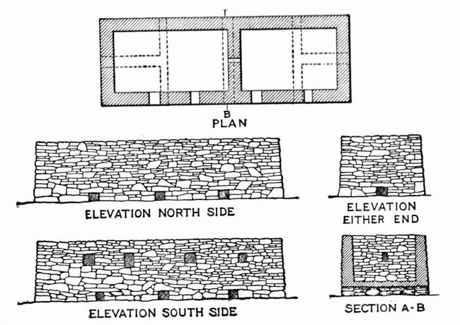 Ruins of YURAK RUMI near Huadquiña. Probably an Inca Storehouse, well ventilated and well drained. Drawn by A. H. Bumstead from measurements and photographs by Hiram Bingham and H. W. Foote. Obviously, we had not
yet found
Uiticos. So, bidding
farewell to Señora Carmen, we crossed the Urubamba on the bridge of
Colpani and
proceeded down the valley past the mouth of the Lucumayo and the road
from
Panticalla, to the hamlet of Chauillay, where the Urubamba is joined by
the
Vilcabamba River.3 Both rivers are restricted here to narrow gorges,
through
which their waters rush and roar on their way to the lower valley. A
few rods
from Chauillay was a fine bridge. The natives call it Chuquichaca!
Steel and
iron have superseded the old suspension bridge of huge cables made of
vegetable
fiber, with its narrow roadway of wattles supported by a network of
vines. Yet
here it was that in 1572 the military force sent by the viceroy,
Francisco de
Toledo, under the command of General Martin Hurtado and Captain Garcia,
found
the forces of the young Inca drawn up to defend Uiticos. It will be
remembered
that after a brief preliminary fire the forces of Tupac Amaru were
routed
without having destroyed the bridge and thus Captain Garcia was enabled
to
accomplish that which had proved too much for the famous Gonzalo
Pizarro. Our
inspection of the surroundings showed that Captain Garcia’s companion,
Baltasar
de Ocampo, was correct when he said that the occupation of the bridge
of
Chuquichaca “was a measure of no small importance for the royal force.”
It
certainly would have caused the Spaniards “great trouble” if they had
had to
rebuild it. We might now have
proceeded to
follow Garcia’s
tracks up the Vilcabamba had we not been anxious to see the proprietor
of the
plantation of Santa Ana, Don Pedro Duque, reputed to be the wisest and
ablest
man in this whole province. We felt he would be able to offer us advice
of
prime importance in our search. So leaving the bridge of Chuquichaca,
we
continued down the Urubamba River which here meanders through a broad,
fertile
valley, green with tropical plantations. We passed groves of bananas
and
oranges, waving fields of green sugar cane, the hospitable dwellings of
prosperous planters, and the huts of Indians fortunate enough to dwell
in this
tropical “Garden of Eden.” The day was hot and thirst-provoking, so I
stopped
near some large orange trees loaded with ripe fruit and asked the
Indian
proprietress to sell me ten cents’ worth. In exchange for the tiny
silver real she dragged out a sack
containing
more than fifty oranges! I was fain to request her to permit us to take
only as
many as our pockets could hold; but she seemed so surprised and pained,
we had
to fill our saddle-bags as well. At the end of the day
we
crossed the Urubamba River
on a fine steel bridge and found ourselves in the prosperous little
town of
Quillabamba, the provincial capital. Its main street was lined with
well-filled
shops, evidence of the fact that this is one of the principal gateways
to the
Peruvian rubber country which, with the high price of rubber then
prevailing,
1911, was the scene of unusual activity. Passing through Quillabamba
and up a
slight hill beyond it, we came to the long colonnades of the celebrated
sugar
estate of Santa Ana founded by the Jesuits, where all explorers who
have passed
this way since the days of Charles Wiener have been entertained. He
says that
he was received here “with a thousand signs of friendship” (“mille
temoignages d’amitie”). We were received the same
way. Even in
a region where we had repeatedly received valuable assistance from
government
officials and generous hospitality from private individuals, our
reception at
Santa Ana stands out as particularly delightful. Don Pedro Duque took
great
interest in enabling us
to get all possible information about the little-known region into
which we
proposed to penetrate. Born in Colombia, but long resident in Peru, he
was a
gentleman of the old school, keenly interested, not only in the
administration
and economic progress of his plantation, but also in the intellectual
movements
of the outside world. He entered with zest into our
historical-geographical
studies. The name Uiticos was new to him, but after reading over with
us our
extracts from the Spanish chronicles he was sure that he could help us
find it.
And help us he did. Santa Ana is less than thirteen degrees south of
the
equator; the elevation is barely 2000 feet; the “winter” nights are
cool; but
the heat in the middle of the day is intense. Nevertheless, our host
was so
energetic that as a result of his efforts a number of the best-informed
residents were brought to the conferences at the great plantation
house. They
told all they knew of the towns and valleys where the last four Incas
had found
a refuge, but that was not much. They all agreed that “if only Señor
Lopez
Torres were alive he could have been of great service” to us, as “he
had
prospected for mines and rubber in those parts more than any one else,
and had
once seen some Inca ruins in the forest!” Of Uiticos and Chuquipalpa
and most
of the places mentioned in the chronicles, none of Don Pedro’s friends
had ever
heard. It was all rather discouraging, until one day, by the greatest
good
fortune, there arrived at Santa Ana another friend of Don Pedro’s, the teniente gobernador of the village of
Lucma in the valley of Vilcabamba — a crusty old fellow named Evaristo
Mogrovejo. His brother, Pio Mogrovejo, had been a member of the party
of
energetic Peruvians who, in 1884, had searched for buried treasure at
Choqquequirau and had left their names on its walls. Evaristo Mogrovejo
could
understand searching for buried treasure, but he was totally unable
otherwise
to comprehend our desire to find the ruins of the places mentioned by
Father
Calancha and the contemporaries of Captain Garcia. Had we first met
Mogrovejo
in Lucma he would undoubtedly have received us with suspicion and done
nothing
to further our quest. Fortunately for us, his official superior was the
sub-prefect of the province of Convencion, lived at Quillabamba near
Santa Ana,
and was a friend of Don Pedro’s. The sub-prefect had received orders
from his
own official superior, the prefect of Cuzco, to take a personal
interest in our
undertaking, and accordingly gave particular orders to Mogrovejo to see
to it
that we were given every facility for finding the ancient ruins and
identifying
the places of historic interest. Although Mogrovejo declined to risk
his skin
in the savage wilderness of Conservidayoc, he carried out his orders
faithfully
and was ultimately of great assistance to us. Extremely gratified
with the
result of our
conferences in Santa Ana, yet reluctant to leave the delightful
hospitality and
charming conversation of our gracious host, we decided to go at once to
Lucma,
taking the road on the southwest side of the Urubamba and using the
route
followed by the pack animals which carry the precious cargoes of coca and aguardiente
from Santa Ana to Ollantaytambo and Cuzco. Thanks to
Don Pedro’s energy, we made an excellent start; not one of those
meant-to-be-early but really late-in-the-morning departures so
customary in the
Andes. We passed through a
region
which originally had been
heavily forested, had long since been cleared, and was now covered with
bushes
and second growth. Near the roadside I noticed a considerable number of
land
shells grouped on the under-side of overhanging rocks. As a boy in the
Hawaiian
Islands I had spent too many Saturdays collecting those beautiful and
fascinating mollusks, which usually prefer the trees of upland valleys,
to
enable me to resist the temptation of gathering a large number of such
as could
easily be secured. None of the snails were moving. The dry season
appears to be
their resting period. Some weeks later Professor Foote and I passed
through
Maras and were interested to notice thousands of land shells, mostly
white in
color, on small bushes, where they seemed to be quietly sleeping. They
were
fairly “glued to their resting places”; clustered so closely in some
cases as
to give the stems of the bushes a ghostly appearance. Our present
objective was
the valley of the river Vilcabamba. So far as we have been able to
learn, only
one other explorer had preceded us — the distinguished scientist
Raimondi. His
map of the Vilcabamba is fairly accurate. He reports the presence here
of mines
and minerals, but with the exception of an “abandoned tampu”
at Maracnyoc (“the place which possesses a millstone”),
he
makes no mention of any ruins. Accordingly, although it seemed from the
story
of Baltasar de Ocampo and Captain Garcia’s other contemporaries that we
were
now entering the valley of Uiticos, it was with feelings of
considerable
uncertainty that we proceeded on our quest. It may seem strange that we
should
have been in any doubt. Yet before our visit nearly all the Peruvian
historians
and geographers except Don Carlos Romero still believed that when the
Inca
Manco fled from Pizarro he took up his residence at Choqquequirau in
the
Apurimac Valley. The word choqquequirau means
“cradle of gold” and this lent color to the legend that Manco had
carried off
with him from Cuzco great quantities of gold utensils and much
treasure, which
he deposited in his new capital. Raimondi, knowing that Manco had
“retired to
Uilcapampa,” visited both the present villages of Vilcabamba and
Pucyura and
saw nothing of any ruins. He was satisfied that Choqquequirau was
Manco’s
refuge because it was far enough from Pucyura to answer the
requirements of
Calancha that it was “two or three days’ journey” from Uilcapampa to
Puquiura. A new road had
recently been
built along the river
bank by the owner of the sugar estate at Paltaybamba, to enable his
pack
animals to travel more rapidly. Much of it had to be carved out of the
face of
a solid rock precipice and in places it pierces the cliffs in a series
of
little tunnels. My gendarme missed
this road and took the steep old trail over the cliffs. As Ocampo said
in his
story of Captain Garcia’s expedition, “the road was narrow in the
ascent with
forest on the right, and on the left a ravine of great depth.” We
reached
Paltaybamba about dusk. The owner, Señor José S. Pancorbo, was absent,
attending to the affairs of a rubber estate in the jungles of the river
San
Miguel. The plantation of Paltaybamba occupies the best lands in the
lower
Vilcabamba Valley, but lying, as it does, well off the main highway,
visitors
are rare and our arrival was the occasion for considerable excitement.
We were
not unexpected, however. It was Señor Pancorbo who had assured us in
Cuzco that
we should find ruins near Pucyura and he had told his major-domo to be
on the
look-out for us. We had a long talk with the manager of the plantation
and his
friends that evening. They had heard little of any ruins in this
vicinity, but
repeated one of the stories we had heard in Santa Ana, that way off
somewhere
in the montãna there was “an Inca
city.” All agreed that it was a very difficult place to reach; and none
of them
had ever been there. In the morning the manager gave us a guide to the
next house
up the valley, with orders that the man at that house should relay us
to the
next, and so on. These people, all tenants of the plantation,
obligingly
carried out their orders, although at considerable inconvenience to
themselves. The Vilcabamba Valley
above
Paltaybamba is very
picturesque. There are high mountains on either side, covered with
dense jungle
and dark green foliage, in pleasing contrast to the light green of the
fields
of waving sugar cane. The valley is steep, the road is very winding,
and the
torrent of the Vilcabamba roars loudly, even in July. What it must be
like in
February, the rainy season, we could only surmise. About two leagues
above
Paltaybamba, at or near the spot called by Raimondi “Maracnyoc,” an
“abandoned tampu,” we came to some
old stone walls,
the ruins of a place now called Huayara or “Hoyara.” I believe them to
be the
ruins of the first Spanish settlement in this region, a place referred
to by
Ocampo, who says that the fugitives of Tupac Amaru’s army were “brought
back to
the valley of Hoyara,” where they were “settled in a large village, and
a city
of Spaniards was founded.... This city was founded on an extensive
plain near a
river, with an admirable climate. From the river channels of water were
taken
for the service of the city, the water being very good.” The water here
is
excellent, far better than any in the Cuzco Basin. On the plain near
the river
are some of the last cane fields of the plantation of Paltaybamba.
“Hoyara” was
abandoned after the discovery of gold mines several leagues farther up
the
valley, and the Spanish “city” was moved to the village now called
Vilcabamba. Our next stop was at
Lucma, the
home of Teniente Gobernador Mogrovejo.
The
village of Lucma is an irregular cluster of about thirty
thatched-roofed huts.
It enjoys a moderate amount of prosperity due to the fact of its being
located
near one of the gateways to the interior, the pass to the rubber
estates in the
San Miguel Valley. Here are “houses of refreshment” and two shops, the
only
ones in the region. One can buy cotton cloth, sugar, canned goods and
candles.
A picturesque belfry and a small church, old and somewhat out of
repair, crown
the small hill back of the village. There is little level land, but the
slopes
are gentle, and permit a considerable amount of agriculture. There was no evidence
of
extensive terracing. Maize
and alfalfa seemed to be the principal crops. Evaristo Mogrovejo lived
on the
little plaza around which the houses of the more important people were
grouped.
He had just returned from Santa Ana by the way of Idma, using a much
worse
trail than that over which we had come, but one which enabled him to
avoid
passing through Paltaybamba, with whose proprietor he was not on good
terms. He
told us stories of misadventures which had happened to travelers at the
gates
of Paltaybamba, stories highly reminiscent of feudal days in Europe,
when
provincial barons were accustomed to lay tribute on all who passed. We offered to pay
Mogrovejo a gratificación of a sol,
or Peruvian silver dollar, for every ruin to which he would take us,
and double
that amount if the locality should prove to contain particularly
interesting
ruins. This aroused all his business instincts. He summoned his alcaldes and other well-informed Indians
to appear and be interviewed. They told us there were “many ruins”
hereabouts!
Being a practical man himself, Mogrovejo had never taken any interest
in ruins.
Now he saw the chance not only to make money out of the ancient sites,
but also
to gain official favor by carrying out with unexampled vigor the orders
of his
superior, the sub-prefect of Quillabamba. So he exerted himself to the
utmost
in our behalf. The next day we were
guided up
a ravine to the top
of the ridge back of Lucma. This ridge divides the upper from the lower
Vilcabamba. On all sides the hills rose several thousand feet above us.
In
places they were covered with forest growth, chiefly above the cloud
line,
where daily moisture encourages vegetation. In some of the forests on
the more
gentle slopes recent clearings gave evidence of enterprise on the part
of the
present inhabitants of the valley. After an hour’s climb we reached
what were
unquestionably the ruins of Inca structures, on an artificial terrace
which
commands a magnificent view far down toward Paltaybamba and the bridge
of
Chuquichaca, as well as in the opposite direction. The contemporaries
of
Captain Garcia speak of a number of forts or pucáras which had
to be stormed and captured before Tupac Amaru could be taken prisoner.
This was
probably one of those “fortresses.” Its strategic position and the ease
with
which it could be defended point to such an interpretation.
Nevertheless this
ruin did not fit the “fortress of Pitcos,” nor the “House of the Sun”
near the
“white rock over the spring.” It is called Incahuaracana,
“the place where the Inca
shoots with a sling.” Incahuaracana
consists of two
typical Inca edifices
— one of two rooms, about 70 by 20 feet, and the other, very long and
narrow,
150 by 11 feet. The walls, of unhewn stone laid in clay, were not
particularly
well built and resemble in many respects the ruins at Choqquequirau.
The rooms
of the principal house are without windows, although each has three
front doors
and is lined with niches, four or five on a side. The long, narrow
building was
divided into three rooms, and had several front doors. A force of two
hundred
Indian soldiers could have slept in these houses without unusual
crowding. We left Lucma the
next day,
forded the Vilcabamba
River and soon had an uninterrupted view up the valley to a high,
truncated
hill, its top partly covered with a scrubby growth of trees and bushes,
its
sides steep and rocky. We were told that the name of the hill was
“Rosaspata,”
a word of modern hybrid origin — pata being
Quichua for “hill,” while rosas is
the Spanish word for “roses.” Mogrovejo said his
Indians told him that on
the “Hill of Roses” there were more ruins. At the foot of the
hill, and
across the river, is
the village of Pucyura. When Raimondi was here in 1865 it was but a
“wretched hamlet
with a paltry chapel.” To-day it is more prosperous. There is a large
public
school here, to which children come from villages many miles away. So
crowded
is the school that in fine weather the children sit on benches out of
doors.
The boys all go barefooted. The girls wear high boots. I once saw them
reciting
a geography lesson, but I doubt if even the teacher knew whether or not
this
was the site of the first school in this whole region. For it was to
“Puquiura”
that Friar Marcos came in 1566. Perhaps he built the “mezquina capilla”
which
Raimondi scorned. If this were the “Puquiura” of Friar Marcos, then
Uiticos
must be near by, for he and Friar Diego walked with their famous
procession of
converts from “Puquiura” to the House of the Sun and the “white rock”
which was
“close to Uiticos.” 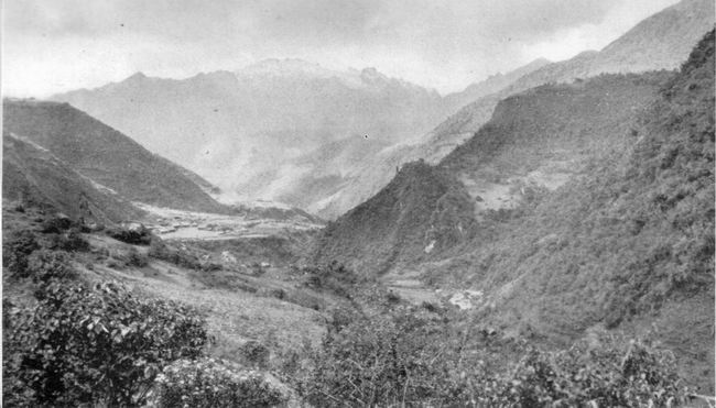 PUCYURA AND THE HILL OF ROSASPATA IN THE VILCABAMBA VALLEY Crossing the
Vilcabamba on a
footbridge that
afternoon, we came immediately upon some old ruins that were not
Incaic.
Examination showed that they were apparently the remains of a very
crude
Spanish crushing mill, obviously intended to pulverize gold-bearing
quartz on a
considerable scale. Perhaps this was the place referred to by Ocampo,
who says
that the Inca Titu Cusi attended masses said by his friend Friar Diego
in a
chapel which is “near my houses and on my own lands, in the mining
district of
Puquiura, close to the ore-crushing mill of Don Christoval de Albornoz,
Precentor that was of the Cuzco Cathedral.” One of the millstones
is five
feet in diameter and
more than a foot thick. It lay near a huge, flat rock of white granite,
hollowed out so as to enable the millstone to be rolled slowly around
in a
hollow trough. There was also a very large Indian mortar and pestle,
heavy
enough to need the services of four men to work it. The mortar was
merely the
hollowed-out top of a large boulder which projected a few inches above
the
surface of the ground. The pestle, four feet in diameter, was of the
characteristic rocking-stone shape used from time immemorial by the
Indians of
the highlands for crushing maize or potatoes. Since no other ruins of a
Spanish
quartz-crushing plant have been found in this vicinity, it is probable
that
this once belonged to Don Christoval de Albornoz. Near the mill the
Tincochaca
River joins the
Vilcabamba from the southeast. Crossing this on a footbridge, I
followed
Mogrovejo to an old and very dilapidated structure in the saddle of the
hill on
the south side of Rosaspata. They called the place Uncapampa, or Inca
pampa.
It is probably one of the forts stormed by Captain Garcia and his men
in 1571.
The ruins represent a single house, 166 feet long by 33 feet wide. If
the house
had partitions they long since disappeared. There were six doorways in
front,
none on the ends or in the rear walls. The ruins resembled those of
Incahuaracana, near Lucma. The walls had originally been built of rough
stones
laid in clay. The general finish was extremely rough. The few niches,
all at
one end of the structure, were irregular, about two feet in width and a
little
more than this in height. The one corner of the building which was
still
standing had a height of about ten feet. Two hundred Inca soldiers
could have
slept here also. Leaving Uncapampa and
following
my guides, I climbed
up the ridge and followed a path along
its west side to the top of Rosaspata. Passing some
ruins much overgrown
and of a primitive character, I soon found myself on a pleasant
pampa
near the top of the mountain. The view from here commands “a great part
of the
province of Uilcapampa.” It is remarkably extensive on all sides; to
the north
and south are snow-capped mountains, to the east and west, deep
verdure-clad
valleys. Furthermore, on the
north side
of the pampa
is an extensive level space with a very sumptuous and majestic building
“erected with great skill and art, all the lintels of the doors, the
principal
as well as the ordinary ones,” being of white granite elaborately cut.
At last
we had found a place which seemed to meet most of the requirements of
Ocampo’s
description of the “fortress of Pitcos.” To be sure it was not of
“marble,” and
the lintels of the doors were not “carved,” in our sense of the word.
They
were, however, beautifully finished, as may be seen from the
illustrations, and
the white granite might easily pass for marble. If only we could find
in this
vicinity that Temple of the Sun which Calancha said was “near” Uiticos,
all
doubts would be at an end. That night we stayed
at
Tincochaca, in the hut of an
Indian friend of Mogrovejo. As usual we made inquiries. Imagine our
feelings
when in response to the oft-repeated question he said that in a
neighboring
valley there was a great white rock over a spring of water! If his
story should
prove to be true our quest for Uiticos was over. It behooved us to make
a very
careful study of what we had found. ________________________
1 Mr.
Safford says in his article on the “Identity of Cohoba” (Journal
of the Washington Academy of Sciences, Sept. 19, 1916):
“The most remarkable fact connected with Piptadenia
peregrina, or ‘tree-tobacco’ is that... the source of its
intoxicating
properties still remains unknown.” One of the bifurcated tubes, “in the
first
stages of manufacture,” was found at Machu Picchu. 2 See
the illustrations in Chapters XVII and XVIII. 3
Since the historical Uilcapampa is not geographically identical with
the modern
Vilcabamba, the name applied to this river and the old Spanish town at
its
source, I shall distinguish between the two by using the correct,
official
spelling for the river and town, viz., Vilcabamba; and the phonetic
spelling,
Uilcapampa, for the place referred to in the contemporary histories of
the Inca
Manco.
Click
 here to continue to the next chapter of Inca Lands
|