|
IV. DAY
TRIPS FROM BOSTON
LEXINGTON
AND CONCORD
Lexington
is reached from Boston by electric car via Arlington, or by train,
Boston & Maine Railroad, North Station. Concord is also
reached by both electric and steam cars. To include both places in a
single trip there is a choice of routes: one wholly by trolley car,
another partly by trolley and partly by steam car (from Lexington to
Concord), a third wholly by train. The route wholly by electrics is
by an Arlington Heights car, passing along Massachusetts Avenue
through Cambridge and Arlington, to the Lexington town line; thence
by a Boston and Lexington electric car, through East Lexington to
Lexington Center, by the historic green; thence to Concord by way of
Bedford, finishing in the main square of the town. To reach Concord
directly from Boston the usual and by far the quickest way is to take
the steam railroad. There are two routes, — one by the Fitchburg
Division of the Boston & Maine, the other by the Southern
Division, the latter being the line which comes through Lexington.
The
trolley-car route to Lexington passes numerous historic points in
Arlington (the early Menotomy, later West Cambridge), all
associated with the affair of the 19th of April, 1775. Before the
town line is reached the visitor must needs be on the lookout for
tablets. In North Cambridge (Cambridge station on the
near-by
railroad) is the first one. This stands just above the church beyond
“Porter’s,” the old hotel, a relic of past days. It marks a
point where four Americans were killed by British soldiers on
the retreat. Two miles and more beyond, after a brick car house is
passed and the railroad crossed, the next tab let may be seen, on the
right side of the road. This marks the site of the Black Horse
Tavern, where three members of the Committee of Safety of 1775 —
Colonel Azor Orne, Colonel Jeremiah Lee, and Elbridge Gerry of
Marblehead — were spending the night of the 18th of April, and
barely escaped capture by the British soldiers on the march out to
Lexington and Concord.
Nearing
the town center, the Arlington House is marked, “Here stood
Cooper’s Tavern, in which Jabez Wyman and Jason Winship
were
killed by the British, April 19, 1775.” A little way beyond this
tavern, at the right, is Mystic Street, down which, a hundred yards
from the avenue, is a tablet inscribed with this marvelous
tale: “Near this spot Samuel Whittemore, then eighty years old,
killed three British soldiers April 19, 1775. He was shot,
bayonetted, beaten, and left for dead, but recovered and lived to be
ninety-eight years of age.” At the junction of the avenue and
Pleasant Street, in front of the church green, a tablet records that
“at this spot on April ,9th, 1775, the old men of Menotomy captured
a convoy of English soldiers with supplies, on its way to join the
British at Lexington.” Behind the church on Pleasant Street is the
old burying ground where a number who fell in the fight during the
British retreat were buried. Farther down Pleasant Street, on the
borders of fair Spy Pond, is the home of John T. Trowbridge,
author and poet.. On the avenue again, above the church green, is the
fine Robbins Memorial Library, and a little beyond this, near
the corner of Jason Street, another tablet appears, identifying the
“site of the house of Jason Russell, where he and eleven others
were captured, disarmed and killed by the retreating British.”
Farther along on the plain near ing Arlington Heights are two or
three old houses which suffered damage in the fight. At the top of
the incline the “Foot of the Rocks,” as this point was
called at the time of the Revolution, is reached. To the left a road
leads up to “the Heights,” from which a beautiful view is to be
had.
The
car stables close to the Lexington line are only a little way beyond.
Here the change is made to the Lexington car a few steps above.
East
Lexington, or the East Village as it used to be called, is now a
tranquil hamlet, with an old-fashioned store or two, some
comfortable, looking houses along the main avenue, a few memorials of
the British invasion, and a little church in which Emerson
occasionally preached (the octagonal structure on the right side of
the avenue, known as the Follen Church, from Charles Follen,
the German scholar, its minister, who was lost in the burning of the
steamer Lexington on Long Island Sound in 1840). At the
junction of the avenue and Pleasant Street is a tablet set up
beside a drinking fount, which marks the point where the first armed
man of the Revolution was taken, — only to rearm him self and fight
later on Lexington Green. He was Benjamin Wellington, a minuteman. A
short distance beyond is a plain white house, on the right side, upon
which is a tablet identifying it as the “home of Jonathan
Harrington, the last survivor of the Battle of Lexington.” This,
how ever, was not the place where Jonathan lived at the time of the
fight. He was a boy then (a fifer to the minutemen) and lived with
his father, another Jonathan Harrington, whose house also is
standing, a little farther on, at the corner of Maple Street. In the
sidewalk in front of the latter house is one of the largest elms in
New England. One day in 1753 the elder Jonathan drove an ox team to
Salem, and on the way back he pulled up an elm shoot to brush the
flies off the oxen. When he got home he set it out, and this great
tree has grown from it.
Lexington.
After passing the rural station of Munroe’s, on the rail road, the
first object of interest, and a worthy one, is Munroe’s Tavern,
standing on an elm-shaded knoll at the left of the avenue. On its
face is a tablet thus inscribed: “Earl Percy’s headquarters and
hospital, April 19, 1775. The Munroe Tavern built 1695.” Percy
occupied the room on the left of the entrance door, and this was made
the temporary hospital. The room on the right was the taproom, where
the soldiers were freely supplied with liquor.
Lexington
When
the retreat began some of the soldiers discharged their guns, killing
John Raymond, who had served them and who was trying to escape
through a back door. A bullet hole made by one of the British musket
balls is still seen in the ceiling of this room. The depart ing
soldiers also started a fire in the tavern, but it was put out. In
the southeast part of the second story was the tavern dining room,
and here Washington dined in November, 1789, when on his last journey
through New England. This house was much larger then, with spreading
outbuildings. Abandoned as a tavern years ago, it has been preserved
as a memorial of the Revolution.
As
the town center is approached historic sites multiply. The hill on
the left is marked as the point where one of the British fieldpieces
was planted to command the village and its approaches. Near it, we
are informed by the same tablet, “several buildings were
buried.” A little way beyond Bloomfield Street, at the left, is
about the point where Percy met Smith’s retreating force, and at
the right, in front of the High School, a granite cannon marks the
spot where he planted a field piece to cover the retreat.
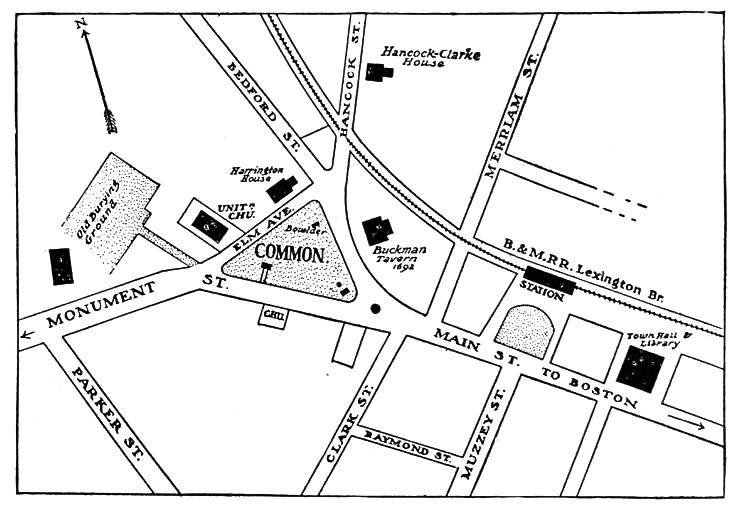
Arrived
at Lexington Green, — the Common where the “battle”
occurred, — the visitor will find every point of importance
designated by a monument or tablet. Thus at the lower end is the
stone pulpit marking the site of the first three meetinghouses, a
“spot identified with the town’s history for one hundred and
fifty years.” Near by is a bronze statue of a yeoman with gun in
hand standing on a heap of rocks. Where the minutemen were lined up
is indicated by a bowlder inscribed with the words of Captain
Parker: “Stand your ground. Don’t fire unless fired upon, but if
they mean to have a war, let it begin here.” On the west side of
the ground is the old stone monument, now in a beautiful
mantle of ivy, which the State erected in 1799, and for which the
patriot minister of Lexington, Jonas Clarke, wrote the oratorical
inscription. In a stone vault back of it are deposited the remains of
those who fell in the engagement, which were removed to this place
from their common grave in the village burying ground. With the
modern houses about the green are three which were standing at the
time of the battle. On the north side is a house in an old garden
which was the Buckman Tavern, “a rendezvous of the
minutemen, a mark for British bullets,” as the tablet on its face
states. On the south side a plain white house bears the legend, “A
witness of the battle.” On the west side, at the corner of Bedford
Street, is a house in which lived Jonathan Harrington, who, “wounded
on the Common” in the engagement, “dragged himself to the door
and died at his wife’s feet.” A few steps from the Unitarian
Church, on this side, is a lane with a bowlder at its corner marked
“Ye Old Burying, Ground 169o.” Among the many quaintly inscribed
gravestones here are the tombs of the ministers John Hancock,
grandfather of Governor John Hancock, and Jonas Clarke, and monuments
to Captain Parker of the minutemen and Governor William Eustis, who
was a student with General Joseph Warren and served as a surgeon at
Bunker Hill and through the war. He was governor of the State in
1823-1825.
On
Hancock Street is the historic Hancock-Clarke house (moved
from its original site on the opposite side of the way), the home of
the ministers, first Hancock and then Clarke. Here John Hancock
and Samuel Adams were stopping the night before the battle,
and were roused at midnight from their sleep by Paul Revere,
when they were taken by their guard to Captain James Reed’s in
Burlington. The venerable house is now a museum of Revolutionary
relics. In the Town Hall, below the green, are the Memorial Hall and
Carey Public Library, in which is a larger museum of relics, with
numerous portraits, old prints, and Major Pitcairn’s pistols,
captured during the retreat. Here are statues of The Minuteman of
‘75; The Union Soldier; John Hancock, by Thomas R. Gould; and
Samuel Adams, by Martin Milmore. In the public hall above is a fine
painting of the Battle of Lexington by Henry Sandham.
Waltham
Street, opening directly opposite the Town Hall, leads toward the
birthplace of Theodore Parker, in Spring Street, about
two
miles distant.
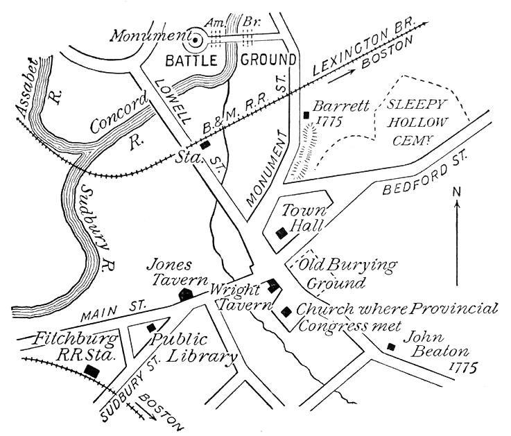
Concord
Concord.
The heart of the town is the square in the center, where the most
conspicuous object is the
Unitarian
Church, destroyed by fire in 1900, and wisely rebuilt on the old
simple and dignified lines. This was the site of a still older
meeting house where the Provincial Congress sat. Next to it is the
Wright
Tavern, dating from 1747. Here Major Pitcairn drank his toddy on
the day of the fight.
Taking
the Lexington road from the square we pass, first, the
Concord
Antiquarian Society’s house, full of relics and old furniture,
and, a little farther, on a road diverging to the right,
|
The
Emerson house, where Ralph Waldo Emerson lived the greater part
of his life and where he died. His study is preserved as he left it.
The house was long after occupied by his daughter, Miss Ellen
Emerson. Returning to Lexington Street and proceeding about a quarter
of a mile, we come to
The
School of Philosophy and Alcott house. The unpainted,
chapel-like building was the home of the school, and the house near
it was the “Orchard House,” in which the Alcott family lived for
twenty years. Here Louisa M. Alcott wrote “Little Women,” which
turned the tide in the family’s fortunes. Just beyond, under the
hill, is
The
Wayside, also occupied at one time by the Alcotts, but better
known as the home of Hawthorne after the return from Europe. Here the
family were living at the time of Hawthorne’s sudden death in New
Hampshire. “Hawthorne’s Walk “is on the crest of the ridge that
rises abruptly behind he house. Returning to the square, we ascend,
on the right, the old
|
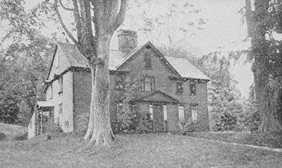
The Alcott House |
Hillside
Burying Ground. Here are historic graves, including those of
Emerson’s grandfather and Major John Buttrick, who led the fight at
the Old North Bridge; and some unique epitaphs, especially that of
John Jack, the slave. The church near this burying ground is now a
Catholic church, and turning the corner of the street on which it
stands, we soon come to
|
Sleepy
Hollow Cemetery. Here, on a high ridge beyond the beautiful
hollow which gives the cemetery its name, are, in proximity, the
graves of Hawthorne, of Emerson, of Thoreau, of Louisa M. Alcott and
her father. Near the foot of this slope should not be over, looked
the Hoar family lot and the beautiful epitaphs placed by the late
Judge Hoar upon the monuments to his father, Samuel Hoar, and to his
brother, Edward Hoar. The exquisitely appropriate inscription on the
Soldiers’ Monument in the square was also written by Judge Hoar.
Returning once more to the square, and proceeding thence on Monument
Street for about half or three quarters of a mile,
The
Old Manse, where Emerson wrote “Nature,” and Hawthorne lived
for a time, is seen on the left, standing back from the road. The
study of both Emerson and Hawthorne was a small room at the back of
the second floor. This house was built ten years before the battle at
the bridge close by, and was for many generations the home of the
minister of the village. Nearly opposite is the house of the late
Judge Keyes, dating from before the Revolution, and in the ell of
which may still be seen the hole through which passed a musket ball
fired at some patriot who was standing in the doorway at the time of
the fight.
The
Battle Ground. The wooded lane just beyond the Old Manse leads to
the scene of the battle at the Old North Bridge, the story of which
is told by the inscriptions on the monuments there. Most pathetic is
the simple inscription which marks the graves of unknown British
soldiers killed on the spot. French’s bronze Minuteman fitly stands
on the opposite side of the river, at about the point where the
Americans made their attack.
|
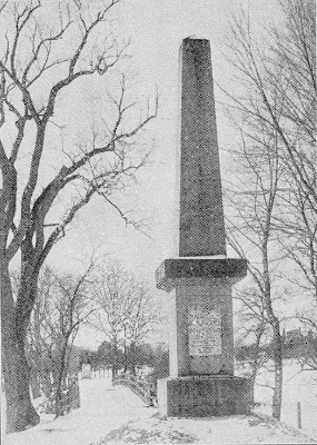
Battle Monument |
House
of the First Minister. If on our way back we turn to the right
after crossing the railroad tracks, and then to the left, we shall
pass the site of the house in which Peter Bulkeley, the first Concord
minister, lived, — he who made the bargain with the Indians for the
land of Con cord, which secured to the colonists its “peaceful
possession.” This is on Lowell Street, and a few steps farther and
facing the square, our starting point, is a low wooden block, a part
of which was one of the storehouses sacked by the British.
Continuing
through the square and turning to the right, the first house beyond
the very pretty bank building is one a part of which is said to have
been the original blockhouse built by the first settlers as a defense
against the Indians. Beyond, on the left, at the junction of the two
roads, is the
Concord
Public Library. Here are some interesting busts and pictures, and
a collection — astonishingly large — of books written by
residents of Concord.
Homes
of the Hoar Family. Continuing on the main street, the fourth
house from the blockhouse was the home of Samuel Hoar, the first of
the name. Here were born his eminent sons, the late Judge Hoar and
Senator Hoar. The next house was the home of the late Samuel Hoar,
the eldest son of Judge Hoar; and the next beyond that is the home of
the widow of Sherman Hoar, Judge Hoar’s youngest son. On the left,
near the corner of Thoreau Street and secluded by a hedge of trees,
is the
Thoreau
House. Here Thoreau lived during the last twelve years of his
life, and here he died of consumption. The Alcott family also lived
in this house for several years. The site of Thoreau’s hut by
Walden Pond is marked by a cairn made by visitors. Still continuing
on the main street and bearing to the right, we find, just beyond the
little stone Episcopal church which stands on the left,
The
Home of Frank B. Sanborn. Here, in what is perhaps the prettiest
house in Concord, and close to the river, lives Frank Sanborn, the
last of the men who gave Concord a world-wide reputation, and famous
as an antislavery man, as schoolmaster, lecturer, and author. A mile
or more beyond the Sanborn house is
The
Concord Reformatory. This institution, intended for younger and
the less hardened criminals, is a large one, and is believed to be a
model of its kind.
Concord
Schools. Concord has always been remarkable for its schools; and
besides its public schools it contains an Episcopal boarding school,
with grounds sloping to the river, not far from the Sanborn house,
and also a Unitarian boarding school, situated on the road to Lowell,
about three miles beyond the village.
Home
of Edward W. Emerson. On the same road, a mile or so beyond the
village, is the home of Emerson’s only son, Dr. Edward W. Emerson,
a physician and artist, and the author of that most valuable and
interesting book, “Emerson in Concord.”
THE
NORTH SHORE
Lynn
(about 12 miles distant from Boston) can be reached in twenty minutes
by steam railroad (Boston & Maine, Eastern Division, from the
North Station) or by the Boston, Revere Beach & Lynn Railroad, a
longer route but running closer to the sea, which begins with a short
trip in a ferryboat, taken at Rowe’s Wharf, Atlantic Avenue (a
station of the elevated railway close by). If time can be spared, one
may journey pleasantly to Lynn in Boston and Northern electric cars,
taken in the Subway at the Scollay Square station, and running
through the Charlestown District (past the Navy Yard), Chelsea,
Revere, and thence straight across the broad Saugus marshes with
their numerous inlets, and with the ocean in sight on the extreme
right. We reach first
West
Lynn. The works of the General Electric Company and numerous shoe
factories are here. A mile or so beyond is Lynn proper, a great shoe
city. At Central Square electric cars may be taken for trips in
various directions, especially to the Lynn Woods, the beautiful
reservation of about two thousand acres. From Central Square, also,
“barges” (a kind of long-drawn bus) run to the aristocratic
summer resort of
Nahant
(“cold roast Boston”), the oldest of eastern summer resorts,
occupying a rocky promontory. On the extreme point is the summer home
of Henry Cabot Lodge. There is also good sea bathing here, cold as
ice water. To the northeast is Egg Rock with its lighthouse, showing
a fixed red light. Returning to Lynn, an electric may be taken, if
one desires, to
Saugus.
Here are the Boardman houses, so called, the homes of minutemen in
1776, and “Appleton’s pulpit,” a huge rock, from which in
September, 1687, Major Samuel Appleton of Ipswich harangued the
people in favor of resistance to Andros. Here also is the site of the
first iron mine and foundry in the Colony.
Returning
again to Lynn, we may take an electric car for Salem via. Swampscott
and Marblehead, — a pleasant route passing many summer homes and
traversing the Lynn Shore Reservation of the Metropolitan Parks
System, which at its northern end joins King’s Beach in Swampscott.
Passing Beach Bluff and Clifton Heights, we come to
Marblehead,
the quaint, irregular town with crooked streets full of old-time
suggestions. Barges or a steam ferry may be taken here to Marblehead
Neck, the site of a summer hotel and of the clubhouses of the Eastern
and Corinthian Yacht Clubs. At the north end of the town is Fort
Sewall, and various islands are in sight, notably “Misery”
island, which is devoted by a club to sports and merriment. Features
within easy walks are the old Town Hall with memories of the
Revolution; the birthplace of Elbridge Gerry; remnant of the historic
Jeremiah Lee mansion; the home and the tomb of General John Glover,
whose statue is in Boston (see page 78); St. Michael’s, the oldest
Episcopal church now standing in New England; the “Old Floyd
Ireson” house; birthplace of “Moll Pitcher,” the “fortune
teller of Lynn”; and the well of the “Fountain Inn,” the old
tavern where began the romance of Agnes Surriage. From Marblehead we
may go by electric car or by steam railroad — or one might have
gone directly from Boston by the Boston & Maine (North Station) —
to
Salem
Salem,
once the chief port of New England. Here are many stately, reposeful
old houses: the Custom House, in which Hawthorne was employed; the
County Jail and Court House, in which many relics of the witchcraft
persecution are preserved; Gallows Hill, where the condemned were
hung; the Roger Williams house; the house on Federal Street in which
Lafayette was entertained in 1784 and Washington in 1789; Hawthorne’s
birthplace on Union Street, and various Hawthorne homes and
landmarks; and the Pickering mansion, built in 1649. Here also are
the Essex Institute and the Peabody Academy of Science, with their
interesting collections of documents, relics, and curiosities, many
of them redolent of the sea and foreign commerce.
Near-by
towns are
Peabody,
named for George Peabody, the London-American banker, with the
Peabody Institute, containing, besides many relics, a portrait of
Queen Victoria, given by her to Mr. Peabody; and
Danvers,
the home of General Israel Putnam, and at one time of Whittier. Here
stands the fine old Hooper or Collins house, one of the best of
Provincial mansions remaining, which General Gage used as his
headquarters in the summer of 1774; and not far away is the Colonial
farmhouse once occupied by Rebecca Nourse, the good house wife and
kind neighbor who was executed for witchcraft.
From
Salem electric cars run through Beverly to the tip end of Cape Ann;
but from Beverly they take an inland course through the towns of
Wenham, Hamilton, Essex, and West Gloucester, whereas the Gloucester
branch of the steam railroad diverges to the east at Beverly and runs
along the coast.
Beverly,
settled in 1628, is now a shoe town in one part and a summer resort
in the other parts. There are many wooded walks and drives here, and
through Pride’s Crossing, Beverly Farms, West Manchester, and
Manchester-by-the-Sea, noted for its “singing beach,” which gives
forth a musical note as one walks over it. Here also is the Masconomo
House, a famous summer hotel and the scene of open-air drama. Beyond
are Magnolia and
Gloucester,
the port from which the hardy fishermen sail to “The Banks” for
cod and haddock, and to which many of them never return. Kipling’s
“Captains Courageous” is the best guide book for Gloucester. At
the extreme tip of Cape Ann is
Rockport,
famous for its granite quarries, for its breakwater, built by the
Federal government, and for its rocky scenery, much haunted by
artists. The Isles of Shoals lie off the shore, and also Thatcher’s
Island, with its twin lights.
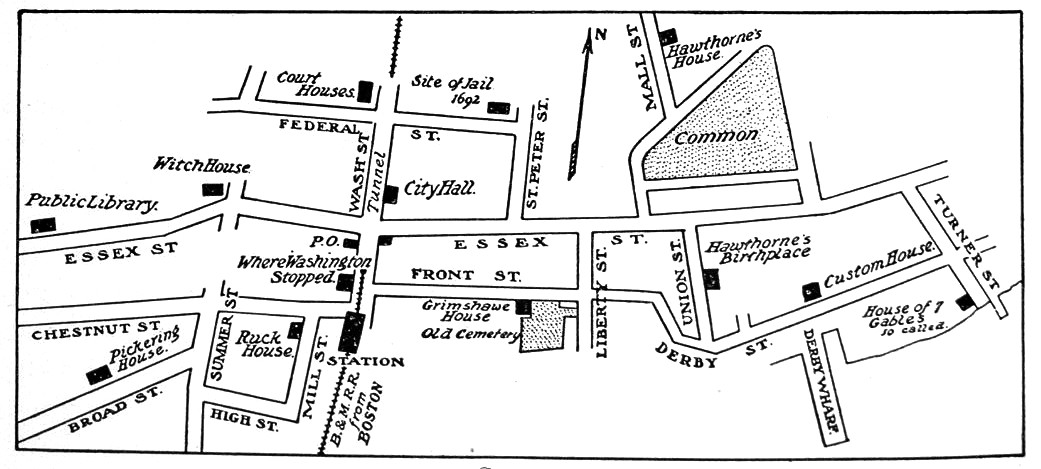
Salem
Itinerary. A day might well be devoted to Salem alone. The
following itinerary, arranged for the visitor who has only an hour or
two for its exploration, embraces the more important or most
interesting places and sites.
The
start is made from Town House Square (Washington Street at the
crossing of Essex Street), a little way above the railroad station.
On Washington Street, between the station and the square, on the west
side of the railroad tunnel, is seen the
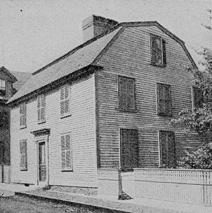
Joshua
Ward House (No. 148), in which Washington passed a night when in
Salem on his tour of New England in the autumn of 1789. He occupied
the northeast chamber of the second story. This house is on the site
of the dwelling of the high sheriff, George Corwin, the
executioner of the witchcraft victims in 1692.
From
Town House Square turn into Essex Street east. The Unitarian Church
on the southeast corner occupies the site of the
First
Meetinghouse, built prior to 1635 for the first church in Salem,
formed in 1629. The present is the fourth in succession on this spot.
The second one was the place of the examinations of the unhappy
accused “witches” before the deputy governor and councilors from
Boston in April, 1692. Beside the third one, “three rods west” of
it, facing Essex Street, stood the
Town
House in which in 1774 met the last General Assembly of the
Province of Massachusetts Bay and the first Provincial Congress. A
short distance up Essex Street, at No. 101, is the
Peabody
Academy of Science (founded upon an endowment by George Peabody,
the American banker in London), in the East India Marine Building.
This contains the natural history and ethnological collections of the
Essex Institute, and the nautical museum of the East India Marine
Society (dating from 1799), with large additions, so arranged as to
be educational rather than merely entertaining. On the opposite side
of the street, at No. 134, is
Plummer
Hall, the house of the Salem Athenæum (proprietary
library, 24,000 volumes). This occupies the site of the house in
which William H. Prescott, the historian, was born, and in which
earlier lived Nathan Read, who invented and successfully sailed a
paddle-wheel steamboat in 1789, some years before Fulton. In Colony
days the Downing-Bradstreet house was here (the homestead lot
being covered by this building and its neighbor, the Cadet
Armory), first the home of the Puritan Emanuel Downing, whose son
George Downing gave his name to Downing Street in London, and
afterward that of Simon Bradstreet, the last colonial governor. Next
above Plummer Hall is the
Essex
Institute (No. 132), which comprises the Institute museum of
historical objects, manuscripts, documents, and portraits, many and
rare, the largest and most notable collection of its kind in the
country; and the library, containing about 85,000 volumes, 302,000
pamphlets, and 700 volumes of manuscript. The visitor upon entering
the Institute should procure a copy of its guide, which gives the
details of the interesting exhibit here.
From
Essex Street on the south side, just above these institutions, turn
into Union Street, which leads to the
|
Birthplace
of Hawthorne, in the ancient gambrel-roofed house, No. 27. This
house dates from before 1692, and belonged to Hawthorne’s
grandfather, Daniel Hathorne (the romancer changed the spelling of
the name) after 1772. Hawthorne was born (1804) in the northwest
chamber. Back of this house, facing on Herbert Street, is the
Herbert
Street Hawthorne House (now
a tenement
house, Nos. 10 1/2 and 12), formerly owned by Hawthorne’s maternal
grandfather, Manning, in which much of the author’s boyhood was
passed, and where he afterward lived and wrote at intervals during
his manhood. His “lonely chamber” was the northwest room of
the third story.
From
Derby Street, which Union Street crosses, pass to Charter Street
northward, in which is the
Charter
Street Burying Ground, “Old Burying Point,” dating from 1637,
fancifully sketched by Hawthorne. Here are graves or tombs of
Governor Simon Bradstreet; the witchcraft judge Hathorne and other
ancestors of Hawthorne; the two chief justices Benjamin Lynde, father
and son; Nathaniel Mather, younger brother of Cotton Mather of
Boston, precociously learned and pious, who died “an aged man at
nineteen years”; Richard More, a boy passenger on the Mayflower;
and “Dr. John Swinnerton, physician,” whose name
Hawthorne
utilized in two of his romances. Adjoining the burying ground is the
|
Birthplace of Hawthorne |
“Dr.
Grimshawe” House (53 Charter Street) of “ Dr. Grimshawe’s
Secret” and “The Dolliver Romance,” — the home of Dr.
Nathaniel Peabody at the time of Hawthorne’s courtship of Sophia
Amelia Peabody, who became his wife. “Dr. Grimshawe” House (53
Charter Street) of “Dr. Grimshawe’s Secret” and “The Dolliver
Romance,” — the home of Dr. Nathaniel Peabody at the time of
Hawthorne’s courtship of Sophia Amelia Peabody, who became his
wife.
On
Derby Street, a short distance eastward, is the
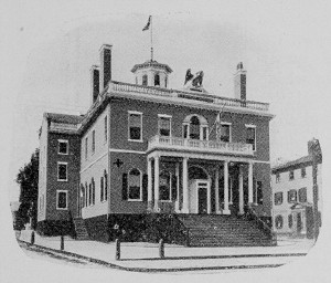
Salem Custom House
The + marks the the
office occupied by
Hawthorne |
Salem
Custom House. The office which Hawthorne occupied as surveyor
of the port in 1846-1849 was the corner room of the first floor, at
the left of the entrance. The stencil, “N. Hawthorne,” with which
he marked inspected goods, is preserved here as a memento; the desk
upon which he wrote is in the Essex Institute. The room in which he
fancied the discovery of the scarlet letter is on the second floor of
the easterly side of the building, in the rear of the collector’s
office. In Hawthorne’s time this was an unused room, with boxes and
barrels of old papers.
Three
or four streets east of the Custom House is Turner Street, by which
return should be made to Essex Street. On Turner Street the old house
No. 54 is marked the
House
of the Seven Gables. This is not correct, for Hawthorne, upon his
own statement, took no particular house for his model in the romance
of this name. The house is interesting, however, as one which
Hawthorne much frequented, it then being the home of the
Ingersoll family, his relatives. It may have suggested the title of
the romance. Here the “Tales of Grandfather’s Chair”
originated.
|
From
Turner Street cross Essex Street to Washington Square, with its
stately houses of early nineteenth-century build, bordering the fine
Common. On the north side, at the corner of Winter Street, is the
Story
House, in which lived Judge Joseph Story, and where his son,
William W. Story, the poet and sculptor, was born.
On Mall Street, the second street from this side, the house No. 14
was
Hawthorne’s
Mall Street House, where “The Scarlet Letter” was written.
The study here was the front room in the third story.
From
the west side of the square take Brown Street to St. Peter’s
Street, thence pass to Federal Street, and so to Washington Street
again by Town House Square. On Howard Street, north from Brown
Street, is the Prescott Schoolhouse, said to be near the site of the
place where Giles Corey, the last victim of the witchcraft frenzy,
was pressed to death. On Federal Street is the site of the
Witchcraft
Jail of 1692, covered by the house (No. 2) of the historical
scholar, Abner C. Goodell. In this jail the persons accused of witch
craft were confined, and from it the condemned were taken to the
place of execution. Some of the timbers of the old jail are in the
present house.
On
Washington Street, just about where Federal Street enters, is the
site of
Governor
Endicott’s “faire house.” At the southern corner of
Washington and Church streets stood the
Bishop
House, where in 1692 lived Edward and Bridget Bishop, the latter
the first witchcraft victim to be hanged. About opposite, on the west
side of Washington Street, near Lynde Street, was the
House
of Nicholas Noyes, minister of the first church at the time of
the witchcraft delusion, and a firm believer in witchcraft. In the
middle of the street here stood the
Court
House of 1692, where the witchcraft trials were held. In the
present Court House, at the end of Washington Street, facing Federal
Street, are
Witchcraft
Documents and Relics, in the custody of the clerk of the courts.
Among these are the manuscript records of the testimony taken at the
trials, the death warrant of Bridget Bishop, with Sheriff Corwin’s
return thereon, recording that he had “caused her to be hanged by
the neck till she was dead and buried,” the last words being
crossed with a pen, apparently by the careful sheriff on second
thought; and some of the “witch-pins” which were produced in
court as among the instruments of torture used by the accused.
Through Federal Street west and North Street north is reached the
North
Bridge, in place of the bridge of Revolutionary days, where the
“first armed resistance to the royal authority was made” on a
Sunday in February, 1775, nearly two months before the affair at
Lexington and Concord, when the advance of the British force, led by
Lieutenant Colonel Leslie, to seize munitions of war, was arrested by
the people of Salem. A spirited painting, “The Repulse of Leslie,”
is in the Essex Institute.
Return
through North Street to Essex Street west. On the corner of North
Street (310 Essex Street) is the
Witch
House, so called persistently without warrant beyond the
tradition that some of the preliminary examinations of accused
persons were held here, it being at the time of the delusion the
dwelling of Judge Jonathan Corwin of the court. It is said to have
been earlier the home of Roger Williams (in 1635-1636). It is the
oldest house now standing in Salem.
Through
Summer Street from Essex pass to Chestnut Street, lined with great
elms and bordered by many fine old-time mansions. At No. 18 was
Hawthorne’s
Chestnut Street House, which he occupied less than two years at
the beginning of the surveyorship period. Little literary work
appears to have been done here. At an earlier period John Pickering,
the Greek lexicographer, lived in this house. On Broad Street, the
next street south, at No. 18, is the many-gabled
Pickering
House, dating back to 166o, the birthplace of Timothy Pickering,
the distinguished soldier and statesman of the Revolution and member
of Washington’s cabinet. Opposite, at the head of Broad Street, is
a succession of school buildings, —
The
Latin and High Schools, the former of which is one of the oldest
in the country. Behind these buildings is the
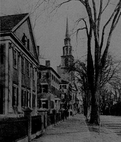
Chestnut Street, Salem |
Broad
Street Burying Ground, second in age to the Charter Street
Burying Ground, having been laid out in 1655. Here are the tombs of
the Pickerings, of Corwin, the witch craft sheriff, and of General
Frederick W. Lander.
Return
to Essex Street, and after a call at the Public Library (No. 370), on
the corner of Monroe Street, and a glance at the fine old-time
mansions of the neighborhood, — notably the Cabot house, dating
from 1748, for a third of a century the home of William C.
Endicott, justice of the State Supreme Court and member of
President Cleve land’s cabinet, — take a car for
Gallows
Hill, where the nineteen victims of witchcraft were hanged. It is
on Boston Street (the old Boston Road), approached from Hanson
Street, where the conductor should be signaled to stop.
Returned
to Town House Square, the visitor may, if he have time, spend a few
minutes profitably in the City Hall in looking over the unusual
collection of portraits here. They include a Washington painted by
Jane Stuart, a copy of a half-length portrait by her father, Gilbert
Stuart; a portrait of President Andrew Jackson by Major R. E. W.
Earle of his military family in 1833; and portraits of Endicott.
South of the railroad station is a nest of old buildings in old
streets, among them the Ruck house, 8 Mill Street, dating from
before 1651, interesting as the sometime home of Richard Cranch,
where John Adams frequently visited (Adams and Cranch married
sisters), and at a later time occupied by John Singleton Copley, the
Boston painter, when here painting the portraits of Salem worthies.
|
THE
SOUTH SHORE
The
pleasant places along the South Shore between Quincy and Plymouth are
brought into connection with Boston and with each other by
electric-car systems, while the steam railroad traverses the country
closest to the shore. The most direct electric-car route from Boston
to Plymouth is through Quincy, Braintree, South Braintree, Holbrook,
Brockton, Whitman, Hanson, Pembroke, the Plymouth Woods, West
Duxbury, and Kingston. For this route the Neponset car should be
taken at the Dudley Street terminal of the Elevated. The trunk line
continues through Quincy to Brockton, where change is made to the
Plymouth line. Other lines between Quincy and Brockton pass through
Quincy Point, across Weymouth Fore River, through Weymouth, cross ing
Weymouth Back River, Hingham, the Old Colony Woods, Nantasket,
Hingham Center, Rockland, and Whitman, making connection at the
latter place with the Plymouth line.
The
pleasantest steam-railroad journey is by the South Shore route (New
York, New Haven & Hartford system, South Station), passing
through Quincy, Braintree, Weymouth, Hingham, Cohasset, Scituate,
Marshfield, Duxbury, and Kingston, to Plymouth. The more direct route
is by the main line through Braintree, South Weymouth, Abington,
Whitman, Hanson, Halifax, and Kingston.
Hingham
is one of the loveliest as well as one of the oldest towns in
Massachusetts (settled in 1633). Its broad main street is shaded by
magnificent elms. Its Old Ship Church, with pyramidal roof and
belfry, dating from 1681, is the oldest existing meetinghouse in the
country, and the quaintest. In the burying ground near it is the
grave of John A. Andrew, the war governor, marked with a
statue by Gould. Comfortable mansions of old type abound in the town.
On a sightly hill is the home of John D. Long, governor,
congressman, and Secretary of the Navy.
Cohasset,
with irregular rocky coast, commanding a wide extent of ocean
prospect, is the most favored place of the upper South Shore for
summer seats. On and about its quite renowned Jerusalem Road are
numerous extensive estates with elaborate houses and grounds. The
Jerusalem Road to an unusual degree blends the charms of
sea
and shore.
Scituate
also enjoys a beautiful ocean front, with fair beaches and a pretty
harbor, protected by rocky cliffs. This town is the scene of
Samuel Woodworth’s lyric, “The Old Oaken Bucket.” The old
farm where the poet was born, which he immortalized in his song, was
close by the present railroad station.
Marshfield
was the country home of Daniel Webster. The Webster place is
some distance from the railroad, eastward. The ride or walk to it is
along a country hillside road, from which beautiful views
occasionally disclose themselves. The place originally included a
part of “Careswell,” the domain of the Plymouth Colony governor,
Edward Winslow. Half a mile back from it is the tomb of Webster,
on Burying Hill, a tranquil spot among fields and pastures
overlooking the sea. Before the tomb, of rough-hewn granite, a plain
marble slab displays the epitaph which Webster dictated the day
before his death (1852). In this inclosure are monuments to early
Pilgrim settlers.
Duxbury,
the home of Elder Brewster, Miles Standish, and John and Priscilla
Alden, is marked by the Standish Monument on Captain’s Hill,
which looms up in the landscape, visible in a wide extent of country
round about. Here is still standing the Standish Cottage,
containing, it is believed, some of the materials of Standish’s own
house, on the slope of Captain’s Hill; and in another part of the
town is the ancient Alden homestead, on the original Alden farm,
which can be seen from the windows of the railroad car. In about the
middle of the village, in the oldest of its burying grounds, the
supposed grave of Standish is marked by a monument, — a
miniature fortress. Here are also graves of the Alden family, and
possibly the grave of Elder Brewster.
Kingston,
part of Plymouth till 1726, when setting up for itself it took its
name of King’s town in honor of George the Second, on his birthday,
is a typical Old Colony town, with a cheerful air of substantiality.
It has a number of interesting landmarks, the most notable being the
Major John Bradford house. Major John was the last of the Bradford
family to possess the Bradford manuscript, now returned from its
adventures and safely housed in the State House at Boston.
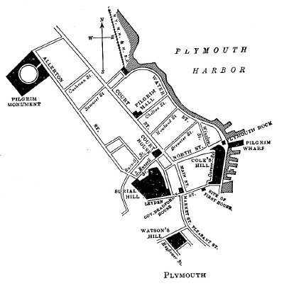
|
Plymouth
is entered by either the railroad or the trolley line, close to its
historic points. A walk not fatiguing from its length will embrace
them all. If arrival is made by trolley car, the National Monument
is passed at the entrance to the town. It is but a short distance
from the railroad station, and if the visitor comes by train it might
well be visited first, although it is in the opposite direction from
the other Pilgrim sites. The way is through Old Colony Park, a short
tree-lined walk from the rear of the station to Court Street, thence,
to the right, to Cushman Street and to Allerton Street. The great
granite pile, surmounted by the colossal figure of Faith, and with
groups of sitting figures, is seen placed to advantage in a broad
open space on the crown of a hill. It was designed by Hammatt
Billings, and finally completed nearly thirty years after the corner
stone was laid.
Returning
to Court Street and approaching the town center, Pilgrim Hall is
reached, a little way beyond the head of Old Colony Park. In the
front yard is a stone tablet inscribed with the words of the compact
signed in the cabin of the Mayflower. The collection in the
halls of the building, comprising Pilgrim antiquities, paintings,
prints, and other historical objects, is of great extent and value.
Most interesting to many visitors is the Standish case, in which is
the doughty captain’s sword, said to be of early Persian make.
|
 |
Above
Pilgrim Hall is the County Court House, on the opposite side
of the street, back from a green park, in which are precious
documents of Pilgrim days. These are preserved in the
office
of the registry of deeds, and include papers bearing the
signatures of Bradford and Standish, orders in Bradford’s
handwriting, Standish’s will, the plan of the first allotment
of lands, the plotting of the first street (t he present Leyden
Street), and the original patent of 1629 granted to Bradford and his
associates.
North
Street, just above the Court House, to the right from Court Street,
leads to Plymouth Rock, under the high granite canopy also
designed by Billings. The side gates in the iron railing are open
during the daytime so that visitors may step upon the stone. Close by
is Pilgrim Wharf.
Cole’s
Hill, where the first houses of the colonists were set up, and
where their first burials were made in unmarked graves, rises from
the opposite side of Water Street, reduced and rounded now from a
ragged elevation to a symmetrical green mound. On the brow is a small
park overlooking the harbor. Here at the head of Middle Street, which
opens from Carver Street, a tablet marks the spot where the skeletons
of two of the forty-four Pilgrims, nearly half the number, who died
during the first hard winter, were found a century and a half after.
These remains, with parts of five other skeletons, are entombed in
the chamber of the canopy over the rock.
Leyden
Street, next beyond Middle Street, the first and chief Pilgrim
street, leads up to Burial Hill. Beyond its start at Carver Street
the site of the first, or “common,” house is seen, marked
conspicuously, on the left side.
Burial
Hill rises abruptly from elm-shaded Town Square, a block from
Main Street, practically a continuation of Court Street. Odd Fellows
Building, on the corner of Main Street, marks the site of Governor
Bradford’s house. The site of the first meetinghouse is
supposed to be covered by the tower of this building. Burial Hill was
the place of the first forts, which served also as
meetinghouses, and these are marked by oval tablets in the burying
ground. The spot where the watch house was erected in 1643 is
similarly marked. The most important monuments here are over the
graves of the Bradfords and of the Cushmans. The Governor Bradford
obelisk occupies a point commanding the fullest view of the town
below. Among other graves of note here are those of John Howland, the
last survivor in Plymouth of the Mayflower passengers, and
Adoniram Judson, the Plymouth minister, father of Adoniram Judson,
the early missionary to Burma.
Watson’s
Hill, where the first Indians appeared to the colonists, and
whence came the friendly Samoset and after him Massasoit, lies to the
southward of Burial Hill. And below is seen the Town Brook
crossing, where Massasoit and his braves were met by the Puritan
leaders, from which meeting resulted the famous “league of peace.”
|


 Click the book image to turn
to the next Chapter.
Click the book image to turn
to the next Chapter.