|
II. THE METROPOLITAN REGION
The
thirty-six cities and towns comprising with modern Boston the
Metropolitan District (see Plate V), all lying in the “Boston
Basin,” or touched by a circle with a radius of ten
miles from the State House, are:
CITIES
— Cambridge, Chelsea, Everett, Lynn, Malden, Medford, Melrose,
Newton, Quincy, Somerville, Waltham, and Woburn.
Towns
— Arlington, Belmont, Braintree, Brookline, Canton, Dedham, Hull,
Hyde Park, Milton, Nahant, Lexington, Needham, Reading, Revere,
Saugus, Stoneham, Swampscott, Wakefield, Watertown, Wellesley,
Weston, Weymouth, Winchester, and Winthrop.
All
of these places, with the exception of Hull and Nahant, are within
the suburban districts of the railroads terminating in Boston, with
frequent train service, and are embraced in the electric-railway
system.
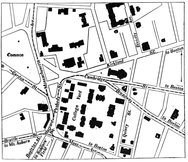
CAMBRIDGE
AND HARVARD
Harvard
Square is our destination, and it is barely a half hour’s ride
by electric car taken in the Subway at Park Street station, or at
Copley Square (Boylston Street), or further out on Massachusetts
Avenue; or by an electric car taken at Bowdoin Square. Let us agree
to go by the latter route, purposing to return by the former, and not
forgetting, ere we board the car in Bowdoin Square, to glance at the
venerable Revere House, and especially at the little iron-railed
balcony from which Daniel Webster delivered many a famous speech. We
soon reach Charles Street, with the County Jail frowning on the
right, and cross Charles River by the new and massive Cambridge
Bridge, completed in 1907.
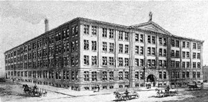
Athenaeum Press
First Street, Near
Cambridge Bridge
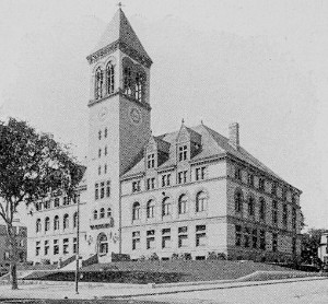
City Hall |
The
river crossed, we find ourselves in busy Cambridgeport so
called, amid factories and workshops, notably the great Athenæum
Press of Ginn & Company, near the river. A mile or so beyond
we pass Cherry Street; and on Cherry Street (at the corner of Eaton
Street) still stands the house in which Margaret Fuller was born.
A little farther on at the left is Magazine Street, where, at the
corner of Auburn Street Washington Allston once lived. Near by
on the right one observes a fine building of reddish granite with
brownstone trimmings and a clock tower. This is City Hall, the
gift of Frederick H. Rindge. The architects were Longfellow, Alden
&
Harlow. A short distance back of the City Hall may be seen a tablet
which marks the spot where General Israel Putnam had his
headquarters during the Siege of Boston. Other city institutions
may be seen by leaving the car at Trowbridge Street, at the end of
which will be found the Public Library (by Ware and Van Brunt,
1889) and the Manual Training School (by Rotch and Tilden). These
buildings also were the gift of Mr. Rindge. Close by are the Latin
School and the English High School.
|
|
Let
us suppose, however, that, with our minds fixed on the Harvard
University, we remain in the car until, rounding a corner,
we come upon a large Baptist church of slatestone. This has no
connection with the university, but it stands in strange contiguity
with Beck Hall, one of the most costly and luxurious of
Harvard dormitories, — not the property of the college. Alighting
here, we find ourselves at once on sacred ground. In front of us, and
to the left, is the “Yard.” To the right and separated
from the yard by Quincy Street is the new Harvard Union,
erected 1901, of which Henry L. Higginson and the late Henry Warren
were the chief donors. McKim, Mead & White were the architects.
It contains offices for the college papers, billiard rooms, a
restaurant, a good library, and a large assembly room. It is a sort
of home or meeting ground for graduates and undergraduates. Just
beyond is the Colonial Club, where may be found the
quintessence of Cambridge, the literary and academic élite.
These buildings are on the right of Quincy Street. Upon the opposite
side of the street, the first house, on the corner and within the
Yard, was formerly the Harvard Observatory. Afterward it
was the home of President Felton, and later of the venerated
Professor A. P. Peabody. The boundary wall of the yard in front of
this building, built in 1901, was given by the class of 1880.
The brick house next above is the president’s house; that next
beyond was long occupied by Professor Shaler. Next stands the newly
erected Emerson Hall in memory of Ralph Waldo Emerson.
|
 |
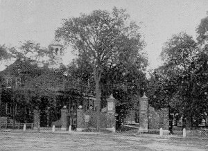
Harvard Main Gate |
Let
us now retrace our steps and, turning the corner by the sometime
observatory, we come first to a gate given by Mrs. Wirt Dexter to
commemorate her son, Samuel Dexter, a member of the class of 1890,
who died in 1894. Next is the gate erected by the class of 1877, and
entering here we find ourselves in front of the Library, or
Gore Hall. The original building was the gift of
Christopher
Gore, a leading lawyer and governor of Massachusetts. Enlargements of
modern date have increased its usefulness, if not its beauty. The
library contains 400,200 bound volumes, and this number is swelled by
outlying collections in various departments of the university to
607,100, — to say nothing of pamphlets. For students who feel
unequal to mastering the library as a whole, a small lot of 22,500
volumes is provided on the easily accessible shelves of the reading
room. Among the valuable private collections that have been
contributed to the library are Parkman’s books, George Ticknor’s
collection of Dante literature, and Carlyle’s collection of books
relating to Cromwell and Frederick the Great. Emerging from the
library and skirting the yard to the right, we come first to Sever
Hall, a recitation building, simple, substantial, and dignified,
the work of the late H. H. Richardson. It was built in 1880 from a
fund given by Mrs. Anne E. P. Sever. To the left is the college
chapel, called Appleton Chapel, a building of light stone
erected in 1858, the gift of Samuel Appleton. Beyond it and facing on
Cambridge Street is a neat building of stone, almost white, brought
from Indiana. This is the William Hayes Fogg Art Museum, erected
in 1895, and given by Mrs. Elizabeth Fogg. It contains a large
collection of casts, statues, engravings, coins, etc., but leaves
something to be desired in point of beauty. Turning sharply to the
left and continuing to skirt the yard, we find at the bend in the
road the Phillips Brooks House, designed by A. W. Longfellow.
It is the center of the religious life of the university. In this
vicinity are two gates, one given by the class of 1876 and one by the
class of 1886.
|
Leaving
this house behind us and turning our steps toward the center of the
Yard, we come first to Holworthy, which was erected in 1812 from
money obtained by a lottery. Back of Holworthy, by the way, is
a gate given by George von L. Meyer, our Secretary of the Navy.
Holworthy from its slightly elevated site at the head of the yard,
occupies a commanding position, and has always been a favorite build
ing. It was the first dormitory that made any pretense to luxury, for
it is arranged in suites of three rooms for “chums,” — a study
in front and two bedrooms in the rear of the building. Class-Day
spreads and Commencement punches always found in Holworthy their
fittest home. In front of Holworthy the Glee Club sings, and noted
men gather in groups. Standing here we obtain the best view of the
beautiful Yard, with its great elms, its shadows, its splashes of
sunshine on the turf; or, of a Class-Day night, its festoons of
Japanese lanterns swaying from tree to tree. Who can number the
romances that have been transacted or begun in the deeply recessed
window seats, in the somber, academic, almost monastic shades of
Holworthy Hall! Time presses, however, and we must glance at the
other buildings in the Quadrangle.
|
Turning
to the right or westerly side of the Yard, we come first to
Stoughton, a dormitory built in 1805. In its rear,
or nearly
so, is Holden Chapel, the gift (1744) of Madam Holden of London, and
once the college chapel. It is now used for society meetings. Just
south of Holden Chapel is a gate given by the class of 1873, and
north of that a gate and sundial erected by the class of 1870. Next
comes Hollis Hall, also a dormitory, which dates back to 1763
and was the gift of Thomas Hollis of London. Three generations of
that family were benefactors of the college. This building was used
as barracks by the American soldiers in the Revolution at the time
when the college was temporarily removed to Concord. Next to Hollis
is Harvard Hall, a building which replaced an earlier Harvard
Hall burned in 1764. The present building was also used as barracks
in the Revolutionary War. It now holds some special libraries.
There is a cupola on Harvard Hall containing a bell which rings for
prayers and recitations. The space between the corners of the
two buildings, Harvard and Hollis, is only five or six feet, and
there is a tradition that once a student, trying to steal the tongue
of the bell, heard the janitor mounting the cupola, and running clown
the steep roof of Harvard, jumped across
the gap and landed safely on the roof of Hollis, whence he escaped.
|
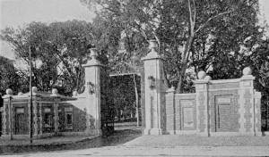
Harvard Gate, Class of
1877 |
Next
in order comes Massachusetts, but between Massachusetts Hall and
Harvard Hall is the principal entrance from the street to the college
yard, through the beautiful Johnston gateway, designed by
Charles F. McKim. This is inscribed with the orders of the General
Court relating to the establishment of the college in 1636-1639 and
this extract:
After
God had carried vs safe to New England
and
wee had bvilded ovr hovses
provided
necessaries for ovr liveli hood
reard
convenient places for Gods worship
and
setled the civill government
one
of the next things we longed for
and
looked after was to advance learning
and
perpetvate it to posterity
dreading
to leave an illiterate ministery
to
the churches when our present ministers
shall
die in the dvst
New
Englands First Fruits.
Massachusetts
Hall, the oldest of the college buildings, was a gift to the
college by the Province in 1720. This hall also was occupied by
troops during the Revolution. Afterward it became a dormitory again,
later a lecture room, and it is now used for meetings and public
purposes. Beyond Massachusetts, in our tour of the Quadrangle, comes
Matthews Hall, a dormitory erected in 1872 through the
generosity of Nathan Matthews of Boston. This hall is said to stand
on the site of the old Indian College, which was built in 1654 and in
which several Indian youths struggled with the classics. One of them,
Caleb Cheeshahteaumuck, took a degree and died. Just beyond Matthews
Hall, and facing on the square, is Dane Hall. This was
formerly the Law School, but is now occupied by the Bursar’s
office, lecture rooms, and a psychological laboratory. We come
next to Grays Hall, a modern dormitory which faces Holworthy
Hall, at the south end of the yard. It was the gift (1863) of Francis
C. Gray of Boston, and its site is probably that of the first college
building. Back of Grays Hall, and close to the street, is an ancient
wooden building, yet of dignified aspect, called Wadsworth House.
This house was built in 1726, jointly by the Province and by the
college, as a residence for the presidents of the institution. It was
Washington’s headquarters until, as we shall presently see, he
removed to the Longfellow house on Brattle Street. The speaker of the
Massachusetts House of Representatives, 1900-1903, James J. Myers,
who after his graduation at Harvard became a tutor and proctor, took
up his residence in Wadsworth House at that time, and, with rare
fidelity, has remained there ever since. Returning now to the
Quadrangle, the substantial granite building standing a little back
and near the street is Boylston Hall, built in 1857 from money
bequeathed by Ward Nicholas Boylston, whose picture, in flowered,
silk dressing gown and cap, lights up Memorial Hall. Boylston Hall is
devoted to chemistry. Next in order, and facing Matthews Hall, is
Weld Hall, a dormitory given to the college in 1872 by
William
F. Weld. Beyond that is a simple, graceful, and dignified building of
white granite, built in 1815 from a design by Bulfinch. It is called
University Hall, and for many years was the main
recitation
building. It is now used as an office building. University Hall and
Sever Hall might perhaps be described as the two buildings in the
yard which are beautiful in themselves, apart from any association.
Beyond University, standing at right angles with Holworthy, is Thayer
Hall, a dormitory given to the college in 1870 by Nathaniel
Thayer.
Passing
out of the Quadrangle and continuing to Cambridge Street, which
bounds the yard on the north, we have within view many buildings,
mostly of recent construction, belonging to the university. Opposite
the Phillips Brooks House, on the other side of the street, is
the Hemenway Gymnasium, given by Augustus Hemenway in 1878. To
the right is the Lawrence Scientific School building, given by
Abbott Lawrence in 1847, and reënforced in 1884 by a building in
Holmes’s Field just beyond, erected by T. Jefferson Coolidge of
Boston. In this last building the visitor may behold an electric
machine given to the college by Benjamin Franklin, and a telescope
used by Professor John Winthrop. Immediately in front of us is a
triangular-shaped piece of ground called the Delta, formerly
the college playground, until Memorial Hall, designed by Ware and Van
Brunt, was built there in the seventies. The statue in the Delta is
an ideal statue of John Harvard, whose bequest of his library
to the college in 1636 was really its start ing point. It is the work
of Daniel C. French, and the gift of Samuel J. Bridge. The exterior
of Memorial Hall may perhaps strike the visitor as lacking
unity and simplicity, but the interior will not disappoint him.
Memorial Hall proper, where are inscribed the names of those Harvard
graduates who died in the Civil War, is noble and impressive; and the
great dining hall, which occupies the whole western end of the
building, with room for over a thousand students, which is paneled
with oak, beautified by memorial stained-glass windows, and filled
with pictures and busts, all of which have an historic and some of
which have an artistic interest, is probably unique in this country.
Cambridge
If,
before entering Memorial Hall (and Sanders Theatre), we turn to the
right on leaving the college yard, we shall come first to Robinson
Hall, at the corner of Quincy Street and Broadway, the
architectural building, containing many casts and engravings. On the
opposite side of Broadway, in the “Little Delta,”
is the old gymnasium, built in 1858, now occupied by the Germanic
Museum.
Of
the many other buildings belonging to the university in this
neighborhood only a few can be mentioned. Randall Hall, at the
corner of Divinity Avenue, with a dining room that seats five
hundred, is a good piece of architecture, constructed by Wheelwright
& Haven. Beyond are the Semitic Museum; Divinity Hall, an
unsectarian theological school; the University Museum,
comprising the Museum of Comparative Zoölogy, the
Botanical Museum, the Mineralogical Museum, the
Geological Museum, and the Peabody Museum, founded
in
1866 by George Peabody, the American banker of London. All of these
are open to visitors, and all contain something to interest even the
unscientific person.
Returning
to the vicinity of the yard, mention should be made of the Law School
building, near the Hemenway Gymnasium, as this harbors one of the
strongest departments of the university. The Harvard Law School
has not only a national but an international reputation, and it has
been described by an English jurist as superior to any other school
of the kind in the world. The building was designed by H. H.
Richardson, the architect of Seaver Hall, to which, however, it is
scarcely equal. The library contains forty-four thousand volumes.
Near this hall once stood the yellow gambrel-roofed house in which
Dr. Oliver Wendell Holmes was born. It was removed about
twenty years ago. The statue of Charles Sumner, by Miss Anne Whitney,
is in the triangular plot of ground near by.
|
Leaving
the university buildings we cross the Cambridge Common to the west of
the yard, formerly, by the way, a place of execution, and once the
scene of an open-air sermon by Whitefield. Here is a bronze statue of
John Bridge, the Puritan, in the garb of his time, an excellent piece
of sculpture by Thomas R. Gould and his son, Marshall S. Gould. In
the roadway, just west of the
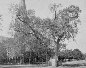
Common,
stands the timeworn Washington Elm, to which is affixed a
tablet stating the historic fact that under this tree Washington
first took command of the American army. Opposite the Washington Elm
is the group of buildings belong ing to Radcliffe College, the
girls’ college, a recognized and highly successful part of the
university. These buildings are on the corner of Garden and Mason
streets.
|
Washington Elm |
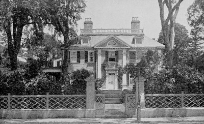
Longfellow House |
This
venture of giving women instruction in the same studies that were
pursued at Harvard was begun in a small way in 1879. It was not a
part of Harvard, but, as a humorous student remarked, it was a
Harvard Annex. The name came into common use. The professors and
tutors as a rule were strongly in favor of the scheme, some even
offering to teach for nothing rather than have it fail. The Annex was
a success. The Fay house on Garden Street was bought. Lady Anne
Moulson in 1643 had given £100 as a scholarship to Harvard, the
first one. Her maiden name was Radcliffe, and as the Annex grew it
was incorporated as Radcliffe College, and now has several fine
buildings, a large number of students, and its diplomas bear the seal
of the older institution and the signature of its president. In the
Fay house, by the way, in 1836, the words of “Fair Harvard” were
written by the Rev. Samuel Gilman of Charleston, S.C.
|
|
Returning
toward the college we pass Christ Church, which was built in
1760 by Peter Harrison, who designed King’s Chapel in Boston.
Washington worshiped here. Adjoining the church is an old burying
ground which dates from 1636, the year of the founding of the
college. Near the fence will be observed a milestone bearing this
inscription: “Boston, 8 miles. 1734.” This was one of many mile
stones set up by Governor Dudley; and what is now a legend was once
true, for, before the bridges were constructed over the Charles River
between Boston and Cambridge, the highway connecting the two places
ran through Boston Neck and what is now Brighton, and was no less
than eight miles long.
|
Lowell House |
Some
outlying spots might well be visited if time allowed, especially the
great Stadium, erected in 1903, and Soldiers Field, the
present extensive playground of the university, a gift of Major Henry
L. Higginson. These are across the river, and near by are the
University and Weld boathouses. Brattle Street,
the
“Tory Row” of Provincial days, is easily reached by electric car
from Harvard Square, and is full of inter est. Here are the stone
buildings of the Episcopal Theological School, and just above
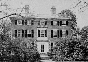
them the Longfellow house, one of the finest of colonial
mansions. It was built about the year 1759 by Colonel John Vassall, a
refugee of the Revolution. Washington took up his headquarters here
when he removed from Wadsworth House, and here Madam Washington
joined him. Afterward the estate passed into the hands of various
owners: was used as a lodging house by Harvard professors when the
widow Craigie owned it; was occupied by such distinguished persons as
Jared Sparks, Edward Everett, and Worcester, the dictionary maker;
and finally became the home of the poet Longfellow. It is now
occupied by a daughter, Miss Alice Longfellow, and next to it is the
home of another daughter who married a public-spirited citizen,
Richard H. Dana, son of the distinguished lawyer who wrote “Two
Years Before the Mast,” and grandson of the poet of the same name.
About ten minutes’ walk on Brattle Street beyond the Longfellow
house brings us to the corner of Elmwood Avenue, which leads
past the familiar Lowell house, where James Russell Lowell was
born, and which was his lifelong home. The seclusion of the house,
which Lowell so much enjoyed, is now impaired by the parkway which
skirts the Lowell grove. Mt. Auburn Street itself has been
modernized by a succession of public hospitals and the like.
Back of these hospitals, on the river, the
curious visitor may behold the site where Leif Ericson built his
house in the year 1001, or thereabout, — according to the
identification of Professor Eben N. Horsford, whose other memorials
of supposed Norsemen we shall encounter later. Close at hand is Mount
Auburn, celebrated for its natural beauty, as well as for the
distinguished dead who lie buried here. In the vestibule
of
the brownstone chapel at the left of the entrance to the cemetery are
the much-admired statues of John Winthrop (by Greenough), John Adams
(by Randall Rogers), James Otis (by Thomas Crawford), and Joseph
Story (by his son). Turning to the left we seek Fountain Avenue and
the graves of the Rev. Charles Lowell, of his son, James Russell
Lowell, and of the latter’s three nephews, all of whom were killed
in the Civil War. “Some choice New England stock in that little
plot of ground.” On the ridge back of this lot is the monument of
Longfellow, and near by (on Lime Avenue) the grave of Holmes. If,
instead of turning to the left from the entrance, we ascend the hill
to the right, passing the statue of Bow, ditch, the mathematician, we
shall come to the old Gothic chapel now used as a crematory. Facing
this stands the famous Sphinx, the work of Martin Milmore. Among
other monuments in various parts of the cemetery are those of William
Ellery Channing (Green-Briar Path), Hosea Ballou (Central Avenue),
Charles Sumner (Arethusa Path), Edward Everett (Magnolia Avenue),
Charlotte Cushman (Palm Avenue), Edwin Booth (Anemone Path), Louis
Agassiz (Bellwort Path), Anson Burlingame (Spruce Avenue), Samuel G.
Howe (near Spruce Avenue), and Phillips Brooks (Mimosa Path). In the
Fuller lot (Pyrola Path) is a monument to Margaret Fuller Ossoli.
From
the cemetery a Huron Avenue car will take us to the Astronomical
Observatory, and by walking through the observatory grounds we
can reach the Harvard Botanic Garden, laid out in 1807. This
garden, open to the public, is full of interesting features, such as
a bed of Shakespearean flowers, another of flowers mentioned by
Virgil, and still another of such quaint plants as grew in an
old-time New England garden.
The
sight-seeing resources of Cambridge are not yet exhausted, but the
sight-seer may be; and so from the Botanic Garden we will take an
electric car for Boston, “stopping off,” however, at Harvard
Square. Across Massachusetts Avenue, at the corner of Dunster
Street, we may observe the site, marked by a tablet, of the house
of Stephen Daye, first printer in British America, 1638-1648.
Here were printed the “Bay Psalm-Book” and Eliot’s Indian
Bible. Farther down Dunster Street, at the corner of Mt. Auburn
Street, is marked the site of the first meeting house in
Cambridge, set up in 1632; and still farther down, at the corner
of South Street, is a tablet where once stood the house of Thomas
Dudley, founder of Cambridge, who lived here in 1630.
From
the south side of Massachusetts Avenue leads off Bow Street, once the
great highway through these parts; and here may still be seen the
colonial mansion occupied in prerevolutionary days by Colonel David
Phips. In the same street the regicides Whalley and Gaffe were
in hiding (1660) until the king, learning of their presence, ordered
their arrest; they fled to New Haven. Just above Bow Street is
Plympton Street, where, shut in by modern brick
dormitories,
is a fine wooden colonial mansion, constructed about 1761 by the Rev.
East Apthorp, rector of Christ Church. Mr. Apthorp, it was supposed,
aspired to be a bishop, and consequently his house was called in
derision the “Bishop’s Palace.” Burgoyne was lodged here
after his surrender at Saratoga.
Taking
an electric car again, we return to Boston via the Harvard Ridge. Two
hundred years ago this would have been a ride on horse back, or in a
chaise, of eight miles, and over a rough road. Now it is a trip of
three or four miles, accomplished luxuriously in less than half an
hour. When the Subway (now building) is finished, it may be
made in half that time. Cotton Mather would have shuddered at the
change; and yet the university is now so large and so completely a
little world in itself, that even the proximity of Boston can hardly
ruffle its composure or divert its scholastic energies.
BROOKLINE
Brookline
is the richest suburb of Boston and in many respects the most
attractive, with numerous beautiful estates and tasteful “villas”
and charming drives. During all the years since its population
entitled it to a city charter, its people have steadfastly refused to
give up their primitive government by the New England town meeting,
just as they have declined all propositions looking to annexation to
Boston, although their territory is embraced on three sides by the
encroaching municipality. It began, however, as a possession of
Boston. As “Muddy River,” so first called from the stream which
still bears the name and contributes no little to the attractiveness
of the Fenway section of the Boston City Parks System, its fertile
fields were originally utilized by the chief settlers at Boston as a
“grazing-place for their swine and other cattle, while corn” was
on the ground in Boston. For a time, through this usage, it was known
as “Boston Commons.” It was set off as an independent town only
in 1705, when the name of Brooklyn was given it, and its inhabitants
were “enjoyned to build a meeting house and obtain an Orthodox
minister,” — so closely were civic and ecclesiastical
prerogatives blended in the government then.
We
may reach Brookline from Boston easily, quickly, and cheaply by
several routes. The Newton Circuit line of the New York Central
Railroad (South Station, or Trinity Place Station, a few steps from
Copley Square) skirts and traverses the town, and has four
stations within its borders. Various trolley lines cover it more
generally, — via Tremont Street and Roxbury Crossing to Brookline
Village; via Boylston and Ipswich streets and Brookline Avenue to the
same point; via Beacon Street to the Chestnut Hill reservoir; via
Huntington Avenue and Brookline Village to several destinations. For
the purpose of rapid exploration the trolley is superior to the steam
railway, and the last-named line is the most convenient. In the
Subway, or on Boylston Street or Huntington Avenue, or at Copley
Square we may take any outward-bound car bearing the legend
“Brookline Village via Huntington Avenue.”
|
Leaving
Copley Square we soon pass the succession of notable buildings about
and beyond Massachusetts Avenue, and presently traverse a somewhat
open territory, observing, as we pass, the Opera House, the Museum of
Fine Arts, and other institutions. On the
left, overlooking the expansive grounds of the Base Ball Club,
southward, we get a fair view of the roofs and towers of the Roxbury
district of the city. On our right, beyond the expanse of land
reclaimed from the primeval salt marsh, we catch glimpses of the Back
Bay Fens, part of the Boston City Parks System (ultimately to be
developed into a region of rare beauty but now in spots forlorn),
which follow the general course of the tortuous Muddy River from its
mouth at the Charles to a point near Brookline Avenue, where they
narrow into the Riverway. The Riverway, passing out from the Fens,
follows the line of Muddy River through Brookline into Leverett Park,
which connects with Jamaicaway leading to Jamaica Park and pond in
the Jamaica Plain district of the city. Here connection is made with
the Arnold Arboretum, or Bussey Park, West Roxbury district (the
territory of the Bussey Institution, Harvard University), which in
turn connects with the extensive Franklin Park lying between the
Roxbury, West Roxbury, and Dorchester districts. Thence this lovely
chain of parkways and parks from the Back Bay district is continued
by Dorchesterway and the Strandway to Marine Park at City Point,
South Boston. The most important part of the Riverway, including the
main driveway, lies within the city limits, while some of its most
charming features and scenic effects are found in the Brookline
section. It is crossed by Brookline and Longwood avenues. Tremont
Street separates it from Leverett Park.
|
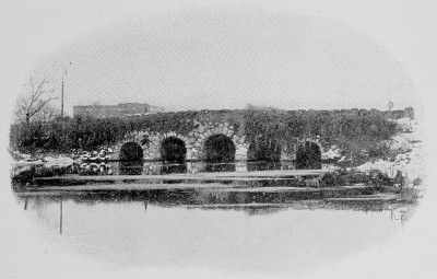
Agassiz Bridge in the Fens |
Near
the Tremont entrance to the Fens from Huntington Avenue we get a
view, on the right, of Fenway Court and Simmons College. Next in our
immediate neighborhood, also on the right, appear the
cluster of high-grade public school houses, and the fine assemblage
of Harvard Medical School buildings described in earlier pages. (see
pp. 91 E, 91 F). A little farther on we pass the House of the Good
Shepherd, a worthy Catholic institution for the shelter and
reclamation of wayward women and girls, — the large brick structure
set in ample grounds.
As
we cross the Riverway just at the foot of Leverett Pond, into
which the river here widens, a pleasing vista opens out to the left.
On either side of the tranquil lake are superb driveways, which of a
pleasant afternoon are crowded with vehicles. A few rods farther on
we are brought to our immediate destination, Village Square,
where free transfers to other trolley lines may be made. Since our
present object is to see something of the historical side of
Brookline, as well as the part wherein is most exhibited the progress
attained in the art of the landscape architect, we will here transfer
to another car. We may remark in passing that on the left of the
street (Washington) by which we entered the square stood in the old
days the “Punch-Bowl Tavern,” built about 1730, — before the
Revolution a favorite junketing place for British officers from the
Boston garrison, and for nearly a century the stopping place of the
stagecoaches for Worcester and other inland towns, and for the great
goods wagons, the pioneers of our modern freight trains.
Boylston
Street, originally the Worcester turnpike, branches off to the
left, and since the Ipswich Street line of cars from Boston,
mentioned above, continues out through this street, we will take one
of them for the rest of our journey in this direction. For a little
way the street is lined with buildings more utilitarian than elegant,
but soon we pass on the left the immense and modernly complete
William H. Lincoln Schoolhouse and enter upon a region of
large and imposing estates, rising to either side of the road on the
great pudding-stone ledges, the country rock of all this section. In
two or three minutes more we come face to face with the granite
gatehouse of the old Brookline Reservoir (fifty years ago the
chief distributing basin of the Boston Water works), still in
service, though its capacity is diminutive as compared with
reservoirs of later date or with the needs of the city.
Here
we will leave the car for a stroll over carless streets in
Brookline’s choicest parts. We take Warren Street up the
hill to Walnut Street, the first turn to the left. On either
side are handsome dwellings with generous grounds, and on the far
corner of Walnut Street stands the fine stone church of the
old First (Unitarian) Parish. A little way below, on Walnut Street,
is the ancient Town Busying Ground, lying close to the
sidewalk, a serene old-time inclosure encompassed by modern
structures, with mounds and vales, rural paths and venerable trees.
Near the street, one of the highest of the mounds contains the tombs
of the Gardner and Boylston families, both prominent in Brookline
town history. Perhaps the most eminent Boylston who lies here was Dr.
Zabdiel Boylston, who introduced in America the practice of
inoculation, as the tablet’s extended inscription relates. He died
in 1766, aged 87. The slab over the Gardner tomb contains thirty
names, among them that of the single minuteman from Brookline killed
at Lexington. A near-by ancient headstone informs that the widow of
the Rev. Increase Mather of Boston lies buried here.
Returning
to Warren Street (named for the famous Boston surgeon, Dr.
John C. Warren, who owned the lands through which it winds), we may
continue for a mile or more between splendid estates with stately
houses set in velvety lawns fringed with trees. At the opening of
Dudley Street is the fine old “Clark house,” built early in the
nineteenth century, latterly the home of Frederick Law Olmsted,
the noted landscape architect, to whose skill a good part of the town
owes much of its beauty. The extensive country seat beyond it,
covering many acres, is the Gardner place, that of the late
John L. Gardner; and on the left hand is the beautiful Sargent
place, the estate of Professor Charles S. Sargent, perhaps the
richest in the town as regards landscape.
At
Cottage Street Warren Street turns off abruptly to the right and,
after a somewhat erratic course, loses itself in Heath Street, which
emerges upon Boylston Street just above the Reservoir. On the
right-hand farther corner of Cottage Street is the unique and
celebrated old Goddard house, whose huge chimney bears the
date 1730. Its quaint architecture, the old-fashioned garden which
surrounds it, and the beautiful trees and shrubs which form its
setting, make it one of the most worthy memorials of Province days.
Next beyond, on the Warren Street side, is the castlelike country
house of the late Barthold Schlesinger, behind noble trees and
dominating a grand expanse of diversified landscape. Joining this
extensive estate is the equally noteworthy Winthrop place, the
former country seat of the late Hon. Robert C. Winthrop, its lands
stretching to Clyde Street. A little farther along, on the left, is
the Lee place, long the summer home of the late Henry Lee, a
sterling Bostonian of his day; on the right, the Augustus Lowell
estate, — these among others; and where Warren Street ends in
Heath, the Theodore Lyman estate, named by some authorities
forty years ago as the finest of modern country seats in this region.
We
skirt this beautiful place as we continue through Heath Street.
Turning down Boylston Street to the right, we soon see on the
opposite (north) side of the way Fisher Avenue, which climbs
over the hill of the same name on top of which are two reservoirs,
one belonging to the city of Boston, the other to the town of
Brookline. On the lower corner of Boylston Street stands the stately
residence of Henry M. Whitney, its sides mantled in ivy.
On a
shaded slope, a little below, is the old Boylston house,
occupying the site of the original homestead of the family, which was
once almost seignorial in this town. Its head was Thomas Boylston,
2d, a surgeon who settled here in 1665, and whose son was the eminent
Dr. Zabdiel Boylston, whose monument we saw in the old burying
ground. One of the daughters was the wife of John Adams and mother of
the second President of the United States. Dr. Zabdiel Boylston built
the present house. During the Revolution it sheltered some of the
patriot troops.
At
Cottage Street, on our route through Warren, we might have turned off
to the south for a walk to Jamaica Pond and Park (Boston City Parks
System), something more than a half mile distant; and at Clyde Street
we might have taken a stroll southwest for three quarters of a mile
to Clyde Park, the property of the Boston Country Club,
where the most fashionable racing events and golf and tennis matches
here abouts take place. But there is more to see in the northern part
of the town.
Accordingly
we take a car back to Village Square, changing there to one bearing
the legend “Newton Boulevard.” This conveys us along Washington
Street, through the business center, past the post office, the steam
railroad station, — trains cross underneath the street, — the
fine granite Town Hall, and the new Public Library building
(capacity of this library, 100,000 volumes) on the right. We now
enter upon a region of ample, homelike-looking houses, generously
encompassed by well-kept grounds.
To
our left we see Aspinwall Hill rise sharply, its sides here
and there showing open patches of pleasant lawn among the
tree-embowered estates. An occasional break in the line of front
walls inclosing the Washington Street properties accommodates a “path
“of steep stairs leading up to Gardner Road, the first of the
series of streets partly encircling the hill. Many others there are,
in sweeping curves or crescents, entering upon and continuing short
bits of straight highway. The landscape architects have happily
avoided the mistake of trying to lay out a swelling hilltop in
rectangles.
We
may alight at Gardner Path, hedge, and vine-bordered, which
will bring us up to the most picturesque part of Gardner Circle.
To our left is the Blake estate, occupying part of the
original Muddy River farm of the Rev. John Cotton, the early colonial
minister of the church in Boston. Above, on one of the most sightly
parts of the slope, stood, until within a year or two, the old
Aspinwall house, shaded by fine elms. Its site now bears a
modern mansion. Dr. William Aspinwall, who built it in 1803, was a
notable physician in his day, a minuteman from the town, and a
patriot all through the Revolution. His house — a grand one in its
period, and to its last day a dignified, ample structure — was once
the only dwelling on this side of the hill, and commanded the whole
sweep of the Charles River and the then distant town of Boston in its
outlook. Ascending to the top of the hill, if we desire, by a sort of
switch-back arrangement of curving and gradually rising roads, we
pass many attractive residences, mostly modern, our highest point
being reached on the S-shaped Addington Road, two hundred and
forty feet above sea level. From here, so far as the breaks between
the rows of apartment houses will permit, we catch glimpses of
country hills to the south, and of the village at our feet; to the
north, across the Beacon Street Boulevard, rises Corey Hill,
two hundred and sixty feet high, formerly part of the extensive farm
of Deacon Timothy Corey, now covered with showy modern estates.
We
can descend to the boulevard in a few minutes by Addington Path and
Winthrop Road, and take any Newton Boulevard car, west bound,
which will convey us shortly to Beacon Circle, directly facing
which is the high embankment and gatehouse of the Chestnut Hill
Reservoir, through which flows a great part of the water supply
of Boston. Here to the left is the High-Service Pumping Station,
a group of solid buildings of some architectural merit, especially
when seen across the beautiful expanse of waters making up the
reservoir. The pumps are among the largest and finest of their class.
From
this point our car turns to the right through Chestnut Hill
Avenue, along the eastern edge of the reservoir, and immediately
we reenter Boston. To our right are various roads with English and
Scotch names, making up the Aberdeen District, an attractive and
healthful addition to the city’s “sleeping room,” lately built
up in the midst of what was primeval forest and ragged ledges of
pudding stone. To our left, as we turn into Commonwealth Avenue,
the grounds surrounding the twin lakes of the reservoir have been
taken by the Metropolitan Water Board and converted into the
Reservoir Park, one of the most restful and charming
pleasure
grounds to be found in the neighborhood of any great city. All around
the winding outlines of the basin runs a trim driveway, and beside it
a smooth gravel footpath. On all sides of the lake are symmetrical
knolls, covered with forest trees and the greenest of turf. The banks
to the water’s edge are sodded and bordered with flowering shrubs;
and the stonework, which in one place carries the road across a
natural chasm, and the great natural ledges, are mantled with
clinging vines, and in autumn are aflame with the crimson of the
Ampelopsis and the Virginia creeper. On the southern side, close to
the narrow isthmus dividing the upper from the lower lake, stands a
classical gatehouse, and behind it Chestnut Hill rears its
wooded mass, crowned with some attractive dwellings. A pleasant,
shaded road winds to the hilltop, which commands a noble prospect.
Our
car continues along Commonwealth Avenue, which here crosses a
high ridge. To the right the view embraces a pretty stone chapel,
thrifty truck patches sloping away from our feet, a deep, verdant
valley, with Strong’s and Chandler’s ponds nestling in its
greenery. At the foot of the hill below us stands the Catholic
Theological Seminary of St. John, a cluster of buildings
imbedded in noble trees. The estate which it occupies was once an
extensive country seat, known as the Stanwood place, comprising many
acres of beautiful wooded land; and much of its beauty in woodland
has wisely been retained. On our left we pass Evergreen Cemetery, and
beyond several handsome estates set well back from the street. At the
foot of the hill, Lake Street, we reach the boundary line of
the city of Newton, and here is a little transfer station, where we
change to a car of the Commonwealth Avenue line, which
traverses the beautiful extension of the famous Boston avenue, —
this part called the Newton Boulevard, — leading to various
sections of Newton and to the country town of Weston.
THE
NEWTONS AND WESTON
Along
Newton Boulevard to the Newtons and Weston. From the transfer
station at Lake Street (reached by all electric cars from the Subway
or Copley Square marked “Newton Boulevard”) our car first climbs
the long slope of Waban Hill, the highest of Newton’s many
hills — three hundred and twenty feet, — lined with modern houses
whose chief recommendation is the charming outlook which they enjoy.
On the summit, to our right, is the reservoir of the city of Newton.
From this point the road stretches out in graceful, sweeping curves
for about five miles, to the old stone bridge crossing the Charles
River to Weston, at nearly the westernmost apex of the town. The
road is practically perfect, — a broad, smooth driveway on either
side of a turfed and shaded park through which the double tracks of
the trolley line run, permitting of high speed. Advantage has been
taken of the naturally diversified configuration of the country to
make the highway as picturesque as possible, and we smoothly climb
lofty ridges, gayly swing down their farther slopes, wind around the
shoulders of swelling knolls, and whirl through shady forest depths
in as much comfort and with nearly as much speed as the occupants of
the many automobiles which find this their most delightful trip out
of Boston.
We
pass between the villages of Newton, Newtonville, and West Newton on
our right; Newton Center, Newton Highlands, and Waban on our left,
and through one edge of Auburndale, which here skirts the river. Our
terminus is the favorite pleasure ground called Norumbega Park,
where the trolley company has provided on the shore of the stream a
variety of attractions for many tastes, — an open-air theater, an
extensive menagerie, a café, and a large boathouse, where
canoes and rowboats may be hired. A launch plies the river between
the park and Waltham, making hourly trips daily, afternoon and
evening.
Canoeing
is the all-engrossing sport on this part of the river, and just
around the bend to our left is the Riverside Recreation Ground. We
cannot see it, for a high wooded promontory shuts off our view; but
we may take a canoe and paddle up through the stone arch of the
Weston Bridge, and in a few minutes we shall be in the
thick
of the fleet at Riverside, where on a pleasant afternoon or
evening the water is often so densely covered that one might almost
cross the stream by stepping from one canoe to another. Frequently
during the summer the fleet parades, decorated with lanterns,
bunting, and flowers, and various water fêtes are held at odd
times. The grounds and boathouses are extensive and well equipped;
and near by are the houses of the Newton Boat Club, the Boston
Canoe Club, and the Boston Athletic Association, whose
large membership helps to swell the crowds upon the river on these
occasions.
As
we stand at the Weston Bridge, looking west, the noble mass of
Doublet Hill, with its twin summits respectively three
hundred
and forty and three hundred and sixty feet high, rises directly
before us. On the hither slope appears the great equalizing
reservoir, having a channel leading to it and great sixty-inch
mains down from it to and across the river, which was constructed by
the Metropolitan Water Board, the work beginning in 1902. A
thirteen-mile aqueduct, much of it tunneled through the rock, brings
the water from the Sudbury dam in Southboro, through Framingham,
Wayland, and Weston, to this new reservoir. The huge mains
constructed during the summer of 1902 along the Newton Boulevard now
convey the additional supply to the Chestnut Hill basins.
From
its summit Doublet Hill presents a fine view of the
surrounding country, and its ascent is easy, either by a path through
the wood or via South Avenue (which forms the western
continuation of Common wealth Avenue through Weston and Wayland) and
Newton Street, which branches off a little to the right
and
leads to Weston village and the station of the Boston & Maine
Railroad. If we take the latter course we shall pass the residences
of many professional and business men, who find Weston a quiet
and healthful home. Thus far the trolley road has not invaded the old
town; but the selectmen have granted a franchise lately to a company
which proposes to build from Waltham, and very soon the ubiquitous
electric cars will be whizzing and clanging through the shady
streets, so long sacred to private vehicles.
To
the left of South Avenue, East Newton Street pursues a winding
course to the river at Newton Lower Falls, a factory village,
where one may take a train for Boston if he so desires. On the way
one passes “Kewaydin,” the extensive estate of Francis
Blake (inventor of the Blake telephone transmitter), a castellated
structure standing on a high, stone-walled hank.
But
probably the most generally interesting spot to be reached by a short
walk from Weston Bridge is the famous Norumbega Tower, built
by the late Professor Eben N. Horsford to commemorate the site of the
Norsemen’s fort founded by Leif Ericson about the year 1000, as
Professor Horsford held. He elaborately carried out his
identification of Watertown with the Vinland of the Northmen, and
traced their wharves, canals, docks, and walls along the river to
this point, the site of their stronghold, where may still be seen —
at least the professor saw them — the remains of the moat and dam
which the Northmen constructed. On this walk a short distance up
South Avenue we take the first turn to the right, River Street, and
follow that street along the riverside for about half a mile, to the
mouth of Stony Brook, which divides Weston from Waltham. The
tower is a structure of field stone, with an inside staircase giving
access to a lookout at the top, and it bears a tablet upon which is
inscribed a detailed description of the Norsemen’s works according
to Professor Horsford’s theory.
Here
the waters of Stony Brook are collected by a dam across the
mouth of the narrow gorge, forming one of the reservoirs of the city
of Cambridge. Beyond it, the towering bulk of Prospect Hill, in
Waltham, cuts off further view in this direction. We might reach
Prospect Hill by a walk of about three miles, but it would
be
better to return to Norumbega Park and Boston.
The
Northern Newtons. By way of varying our route and seeing some
thing of the northern Newtons, we will take a red car, which
turns off the boulevard at Washington Street and follows that
chief thoroughfare of this section down the steep incline through
West Newton, a convenient and — away from the railroad — a pretty
residential section. This is also the civic center of Newton, the
City Hall standing near the New York Central Railroad
station.
We pass it soon after reaching the foot of the hill, Washington
Street swinging around to the right and hence forward following the
steam railroad tracks. These were depressed a few years ago, at great
expense, so as entirely to eliminate grade crossings — of which
there were many — throughout the city. This street is the chief
business avenue all along through Newtonville to Newton, —
anciently Newton Corner, — where our line ends and we may transfer
to cars for other villages or for Boston, via Brighton and
Commonwealth Avenue.
Taking
one of the latter, a ride of less than five minutes through Tremont
Street brings us to Waverley Avenue, where we alight if we
wish to see the Eliot Monument, commemorating the first
preaching to the Indians by John Eliot, “the apostle.” It is
rather a stiff climb up Waverley Avenue to Kenrick Street (on the
left), and a few minutes’ walk along Kenrick Street to a lane on
the right, which leads a few steps down to the unique monument, — a
handsome balustraded terrace, on the face of which are set tablets
bearing the names of Eliot and his associates, and this inscription:
Here
at Nonantum, Oct. 28, 1646, in Waban’s wigwam near this spot, John
Eliot began to preach the gospel to the Indians. Here he founded the
first Christian community of Indians within the English colonies.
The
view from the top of the terrace is very fine. It embraces much of
the ground which we traversed on our way out from Boston, including
the wooded slope of Waban Hill just opposite, Strong’s and
Chandler’s ponds in the valley to our left, and St. John’s
Catholic Seminary in its grove close beside the Boulevard.
We
may, if we wish, cross over Waban Hill via Waverley and Grant
avenues, returning to Lake Street transfer station, and choose one of
two or three pleasant routes back to the city. The cars via
Coolidge’s Corner and the Beacon Street boulevard
will show us all the latest triumphs of the builder’s art in blocks
and apartment houses; those via Commonwealth Avenue will take us
swiftly over a magnificent ridge, — the northwestern end of Corey
Hill, — from the top of which a sweep ing view is had of Boston,
Cambridge, and many towns beyond. The road is winding and runs up
hill and down dale, like its Newton prolongation; and since it is not
largely built up as yet, and there are few intersecting streets, our
speed is but little less than that of the automobiles which make this
a favorite course. Either car we may take will soon bring us back to
Copley Square or the Subway.
Newton
was originally part of Cambridge, but in 5695 was set off as Newton
by the General Court, its previous designation having been Little
Cambridge. Its Indian name of Nonantum is perpetuated in one of the
least attractive of its many villages, — a manufacturing hamlet on
the north side, separated from Watertown only by the river. The area
within the city limits is nearly thirteen thousand acres, and its
contour is very diversified, a number of fine hills rising to heights
of from two hundred to three hundred and twenty feet. The Charles
River forms the meandering boundary line, separating Newton from
Watertown, Waltham, Weston, Wellesley, and Needham, successively. The
main line and also the Newton Circuit branch of the New York Central
Railroad traverse the city and serve the various sections with a
dozen stations. A number of electric lines, radiating mostly from the
business center, — anciently Newton Corner, now plain Newton, —
thread all sections.
NEWTON
AND WELLESLEY
The
many trolley lines radiating from Boston to all its suburbs make it
easy to reach widely separated places of interest in a single
afternoon, or at most in a day. In such a trip could be included the
southern Newtons, Wellesley, Natick, Needham, Waltham, and Watertown.
The territory embraced in these places is very extensive; but if,
instead of describing the wide arc of a circle including them, one
traverses several chords of that arc, the various points are easily
and rapidly covered.
Essaying
first the southernmost of these chords, we may take a Boston &
Worcester car in Park Square, thence ride out through Brookline and
Newton via Boylston Street and its continuations in Wellesley, almost
in a bee line to Natick; or we may take at the Subway a car for the
Reservoir, marked Newton Boulevard, and change there for a car
passing along the Newton Boulevard to Washington Street, Newton;
thence to the left through Auburndale and the “Lower Falls” to
the same destination.
If
we choose the route last mentioned, — by way of the Newton
Boulevard, — our course from the intersection of the Boulevard and
Washington Street, in Newton, is up quite a steep rise, past
the Woodland Park Hotel on the right, — a roomy, wooden building,
in wide-spreading, shaded grounds. At the next street opening above
we get a glimpse of the large building of the Lasell Seminary,
a noted school for girls; and a little farther on we cross the track
of the Newton Circuit steam line, the Woodland station being close at
our right. We pass attractive houses by the way, nearly all
surrounded by generous grounds and several shaded by natural forest
trees. As we cross Beacon Street we pass the Newton Hospital, an
excellent example of the cottage type of such institutions, standing
in large and well-kept grounds.
Our
course continues in the same general direction, southwest, to Newton
Lower Falls, a small, conventional factory village, where the
water power of the Charles River has been utilized to propel woolen
mills and one or two paper mills since about 1790. An ancient burying
ground here contains the graves of Revolutionary soldiers.
At
this point we cross the river and enter the town of Wellesley.
For the rest of our way the trolley track parallels the main line of
the New York Central Railroad. That part of Wellesley through which
we first pass is locally known as “The Farms,” though the
village and railroad station are some distance to our right.
Wellesley is by nature one of the most picturesque towns in eastern
Massachusetts, and its natural beauties have been enhanced by the art
of the landscape architect.
As
we continue along Washington Street, to our left rises Maugus
Hill, three hundred feet high, on top of which is the town
reservoir. About a mile from the town line we pass the neat stone
Wellesley Hills station of the steam railroad, which just
above has made its way through a deep rock cutting in the high ledge.
Above the station is the Wellesley High School building.
Beyond is an attractive stone church (Unitarian). Nearly a mile
farther, in a picturesque inclosure of ten acres, shaded by fine
trees and bordered on its hither side by a gurgling brook overhung
with water willows, stands the Wellesley Town Hall and Public
Library building, a gift to the town by the late H. Hollis
Hunnewell, all complete, in 188x, when the town was set off from
Needham and incorporated (its name being taken from Mr. Hunnewell’s
notable estate, which in turn was named from Mrs. Hunnewell’s
maternal grandfather, Samuel Welles, who about 1750 owned the place).
The Town Hall is of stone, in the style of a French chateau, with
porch facing the square, surmounted by a clock. The library is a
distinct part of the building, with a separate entrance.
A
short distance beyond we come to Wellesley Square, where is
the Needham trolley line. Here carriages may be taken for a drive to
the Hunnewell estate, which is generously open to the
public.
An hour may profitably be given to visiting it. The grounds embrace
five hundred acres, of which sixty acres nearest the house have a
frontage on the beautiful Lake Waban, named for the Indian
chief who was Eliot’s first convert. Two long avenues of fine trees
extend from the public way to the house, on one side of which is a
vast lawn, on the other a French parterre, or architectural garden.
Broad flights of stairs lead down therefrom to the parapet wall along
the lake front, through successive terraces with evergreens on either
side, trimmed into various fanciful forms. Along the lake shore is an
Italian garden, with prim array of formal clipped trees. Great hedges
of hemlock and arbor vita, fine vistas down avenues of purple beeches
and white pines, extensive conservatories, and a graceful azalea
tent, all add to the charm of the place.
Near
by is the Robert G. Shaw estate, a picturesque mansion house
set among fine trees and surrounded by beautiful lawns. Not far away
— just where the Charles River in one of its most sinuous bends
forms the boundary line between Wellesley and Dover — is the Cheney
place, country seat of Mrs. B. P. Cheney, widow of a pioneer in
the express business of America and in transcontinental railroads, an
estate of two hundred acres. The views up and down the river here
enhance the natural beauties of the land, which is highly
diversified. The estate is laid out in a mingling of lawns, flower
gardens, woods, groves, meadows, and fields. The five great elms
which surround the house, tradition says, were brought from Nonantum,
now Newton, and planted here by one of the friendly Indian tribe whom
Eliot taught. The lawn of six teen acres, inclosed by fine hedges, is
one of the noteworthy features.
Still
farther south — indeed almost at the southern boundary of the town,
where Ridge Hill, two hundred feet high, slopes to the placid waters
of Sabrina Pond — is the famous Ridge Hill farm, of eight
hundred and seventy acres. This attained most of its fame during the
life time of a former owner, William Emerson Baker, who made a
fortune in sewing machines, and who delighted in giving great fêtes
here on occasion, providing for the amusement and mystification of
his guests various surprises, droll and bewildering, sumptuous
feasts, and odd sports.
But
Wellesley’s chief fame lies in Wellesley College, for women,
which crowns the rounded hilltops on the north side of Waban Lake,
toward which its 300 acres of grounds gently slope. On the
lake
are the college boathouses, whence on “Float Day” go forth the
class crews of young women to show off their prowess as oarswomen
before the admiring gaze of relatives and friends ashore. The college
is at the left of Central Street, through which our car continues on
its way to Natick. A short distance beyond the square, as we cross
Blossom Street, we catch the first glimpse of the buildings and pass
Fiske Cottage at one of the entrances to the grounds, A little
beyond, the white dome and low, square building of the new
observatory — gift of Mrs. Sarah E. Whitin of Whitinsville — cap
a gentle hillock. As we near the North Lodge, opposite, across the
valley, on the crest of a fine ridge, stands College Hall, the main
building, designed by Hammatt Billings. Its ground plan is a double
Latin cross, and its façades are broken by bays, pavilions,
and porches, topped by towers and spires. Within, the great central
hall is open to the glass roof, eighty feet above. In this building
are the college offices, the library, the original chapel, class and
lecture rooms, and laboratories; also dormitories and a dining-room.
Other
buildings are Stone Hall, gift of Mrs. Valeria G. Stone of Malden,
devoted to botanical work and dormitories, on another knoll
overlooking the lake; the Farnsworth Art Building, gift of Isaac D.
Farnsworth of Boston, on an eminence opposite College Hall; the Music
Hall, the Memorial Chapel, gift of Miss Elizabeth G. and Mr. Clement
S. Houghton of Boston; the Chemistry Building; a group of dormitories
of Elizabethan architecture; Mary Hemenway Hall, with the Gymnasium:
the dormitories and the gymnasium completed in 1910. The main avenue
winds through woodland and meadow from College Hall to the East Lodge
at the entrance on Washington Street.
Wellesley
College was founded by the Hon. Henry F. Durant, formerly a
conspicuous member of the Massachusetts bar, who died in Wellesley in
1881, aged fifty-nine. The greater part of his fortune was devoted to
its establishment as a non-sectarian institution for the purpose “of
giving to young women opportunities for education equivalent to those
usually provided in colleges for young men.” In this work he had
the ardent coöperation of his wife, Mrs. Pauline Adeline (Fowle)
Durant, who continues, since his death, her devotion to the work
which jointly they planned. The college was chartered in 1871 and
formally opened in 1875. The scheme of its founder included these
features: a faculty of women and a selected board of trustees
composed of both women and men, in whom the property of the college
and its official control should be vested.
Our
car passes for nearly a mile along the northern side of the college
estate, and at the farther end stands another lodge at its western
entrance.
NATICK
AND NEEDHAM
We
continue along Central Street and soon cross the line into the town
of Natick. At our left rises Broad’s Hill, three
hundred feet high; at our right is the railroad, close alongside. We
reach Natick station in fifteen minutes from Wellesley Square. The
village is chiefly devoted to shoe manufacturing. Here is the Morse
Institute Library, founded by the bequest of Mary Ann Morse, who
died in 1862. It was dedicated on Christmas day, 1873. Here also is
the former homestead of Henry Wilson, the “Natick cobbler,”
as he was known for many years, who rose from the shoemaker’s bench
to the Senate of the United States and the Vice Presidency. It is a
roomy, plain house of wood, painted white, standing back a little way
from the street, under majestic elms. In the square near the station
is the Soldiers’ Monument of the Civil War, flanked by brass
siege guns.
A
branch trolley line runs hence to Needham, and if we desire to see
more relics of the Indian apostle Eliot, we may take the car to South
Natick, only a mile and a half southeast. On the way we pass over
Carver Hill, two hundred and eighty feet high, whence a
splendid view of the upper Charles River country is gained. In the
South Natick village center was the Eliot Oak, under which,
tradition says, Eliot preached his first sermon to his then newly
established plantation of praying Indians, in 1650. Here he did much
of his work of translating the Bible into the Indian language; and
here, in 1651, his converts built their first schoolhouse and church.
Here, also, are to be seen the Eliot Monument, set up by the
citizens in 1847, and the headstone from the grave of Daniel
Takawambait, the first native minister, set into a granite block
alongside the near-by sidewalk. The Eliot Church (Unitarian)
is the fifth on the site of the rude structure reared by the red men.
It is a typical New England meetinghouse of the early nineteenth
century. It has no connection, except by name and location, with that
founded by Eliot.
South
Natick is said to have been the original Oldtown of Harriet Beecher
Stowe’s “Oldtown Folks.”
From
here to Needham, about five miles, the route lies mostly through a
smiling farming country. We cross the Charles twice within a mile,
and at Charles River Village, which we pass midway, its waters
drive some paper mills. Needham is a quiet, dignified village
of the conventional type, with a fine new high-school building and
one or two other public edifices of brick.
Changing
here to a car for Newton, a ride of a mile north brings us to
Highlandville, the north village of Needham, where a
Carnegie
public library has lately been raised, and where are a couple of shoe
factories. Two miles farther, in a generally northeasterly direction,
the trolley line again crosses the Charles River, which, since
we left it at South Natick, has made divagations into Dover and
Dedham, skirted West Roxbury, and has assumed a path of comparative
rectitude as the boundary line between Needham and Newton.
THE
SOUTHERN NEWTONS
The
railway enters the factory village of Newton Upper Falls, and
traverses several rather depressing streets in the zigzags necessary
for the car to mount the lofty brownstone cliff through which the
river cut its way in ages past, and at the foot of which the village
nestles.
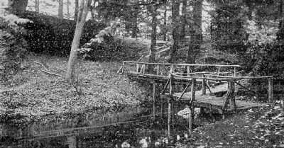
Rustic Bridge and Cave,
Hemlock Gorge |
It
will interest us more if we leave the car just before it crosses the
bridge and take the path, plainly marked, to the left, into Hemlock
Gorge, one of the smallest but most picturesque of the
Metropolitan Park Reservations. Its area is only about twenty-four
acres, but it includes a wild, rocky chasm, through which the swift,
narrow river makes its way, dense thickets, and a grand growth of old
hemlocks towering over all. This park was established in 1895. At its
upper end is the famous Echo Bridge, perhaps the most
photographed bit of masonry in the neighborhood of Boston. It is a
finely proportioned structure, reminding one much of the noted Cabin
John Bridge near Washington, though on a smaller scale. It is the
means by which the aqueduct from the Sudbury River crosses the
Charles on its way to Boston. We may walk across it, enjoying the
attractive outlook over the river, the falls, and the gorge, and
descend by the stone stairs to the bank of the stream and try the
remarkable echoes which give the bridge its name. From the northern
end of the bridge a narrow plank walk between two houses brings us
out to Chestnut Street, where we may again take the car, which, sweep
ing around the right, along the edge of the high cliff, gives a good
view of the village at its foot.
|
The
most direct route from Boston to Echo Bridge and Hemlock Gorge is by
a Boston & Worcester trolley car, which passes over the Back Bay,
through Brook line and Newton, directly to the upper end of the
Gorge, where the deep, black water sweeps through the narrow chasm
close beside the track. Alighting here, one can explore the
reservation in a short time. By this route, also, it is a delightful
ride to Wellesley Hills (where the line crosses that of the Natick
cars by which we came out), and so on to Framingham and Worcester.
Continuing
a mile or so farther, in the same general direction, we cross the
tracks of the New York Central Railroad, and also those of the Boston
& Worcester electric railway, at the neat and busy village of
Newton Highlands. All about on the swelling slopes, in
attractive modem houses, dwell many of Boston’s business men.
Swinging around to the left into Walnut Street, our course is over a
wooded eminence thickly studded with residences. Descending its
farther slope, we pass on our left the Gothic arched entrance of the
Newton Cemetery, one of the most beautiful, by nature and
art,
of any around Boston. A little farther down we see, away to our left,
the great power house of the street railway system.
At
the Newton Boulevard, where is a commodious waiting room, one
may transfer to cars for Boston or to other parts of Newton. We might
take a side trip hence to Newton Center via Homer
Street, but the route is not particularly attractive; a better way to
that pretty village is reached by taking a Boulevard car from Boston,
and changing at Centre Street. This route passes the old burying
ground of the town, where lie the first settlers, a great granite
monument of modern date bearing their names. Of a later period are
the graves of heroes of the French and Indian and Revolutionary wars,
— Major General William Hull, Brigadier General Michael Jackson and
sons, officers in the Revolution, the son and namesake of the apostle
Eliot, and others noted in the early annals of the town. The old
first parish church formerly fronted this ground, and its first
pastor was buried here in 1668. At Newton Center are many beautiful
residences, and on Institution Hill stand the buildings of the Newton
Theological Institution, founded by the Baptists in 1826, as a
training school for the ministry. Its grounds are extensive, and the
view in all directions is inspiring. Within the past few years, under
the presidency of the Rev. Nathan E. Wood, D.D., much money has been
added to the funds of the school, a new library, chapel, and
dormitories have been built, and the whole hilltop has been laid out
in most attractive landscape style. At the foot of the hill lies
Crystal Lake, as the former Wiswall’s Pond is known. It was named
from old Elder Wiswall, in whose homestead it was included. A
splendid road around its shores is one of the attractions of “the
Center.” The stone Baptist church, of Romanesque architecture, is
one of the finest in Boston suburbs.
But
our car is bound north, to Newtonville, and immediately after
crossing the Boulevard we pass a forest-covered hill on the left,
while to our right is a deep, shady valley, through which brawls a
swift brook down rocky ridges. It is a charming section, and some of
the prettiest homes of the city are along this way. One famous estate
which we soon go by is Brooklawn, once the home of General
Hull, of Revolutionary fame; since 1854 that of ex-Governor William
Claflin, who has dispensed hospitality to many distinguished guests
here. Just beyond, on the left, is the stately High School; on
the other side, the Claflin School; and again on the left, the
attractive house and grounds of the Newton Club. A little
farther on we come to the business center of Newtonville, where we
cross the New York Central tracks and Washington Street. Here change
may be made for Newton proper and most of the other villages. Soon we
turn into Watertown Street and pass through the village of Nonantum,
where on the left are the Nonantum worsted mills; also a tiny pond,
bearing the lofty title of Silver Lake.
In
a few minutes, turning sharply to the right, we are in Galen Street,
in the small corner of Watertown lying south of the Charles,
leading to the broad new bridge, replacing an old-time one, by which
we are to cross into Watertown Square.
As
we cross the grand stone bridge we miss the granite tablets which
were on either side of the old bridge. These were erected by the late
Professor Eben N. Horsford, one of them to mark his Norsemen
sites, — that on the left inscribed “Outlook upon the stone
dam and stone walled docks and wharves of Norumbega, the seaport of
the Northmen in Vineland.” The other had this inscription: “The
old bridge by the mill crossed Charles River near this spot as early
as 1641.”
WALTHAM
It
is but a few steps to Watertown Square, where cars from Boston
and Cambridge arrive by several routes, and where we change to a car
for Waltham. Our course all the way is along old Main Street,
to the foot of Prospect Hill, at the terminus of the route.
Here we alight and, following the plain directions on guideboards,
climb, first by the street crossing the Central Massachusetts
Division of the Boston & Maine Railroad, and afterward by a
winding path through the natural woodland park which the city of
Waltham has made of the upper part of the hill, to its summit. From
the outlook, four hundred and eighty, two feet above sea level —
the highest eminence in the Metropolitan district except the Great
Blue Hill in Milton, — we may see to the north, on a clear day, as
far as Kearsarge (seventy-five miles) and several other mountains of
southern New Hampshire; as well as Wachusett, Watatic, and
Asnybumskit in central Massachusetts. The view embraces all the towns
within a radius of twenty miles or more. In taking this noble hill
and laying it out as a reservation, the city has wisely refrained
from “fixing it up” or making it a “parky” affair. Its
wildness and naturalness are its chief charms.
Returning
to Main Street, we will take a car for about a mile east, passing
along the pleasant, shaded thoroughfare, to the Common, on
which stands the Soldiers’ Monument, and near which is the station
of the Fitchburg Division, Boston & Maine Railroad. A branch of
the trolley company’s lines to Newton, by the Moody Street bridge,
crosses the Charles River just south of the Common. On our way down
from Prospect Hill, three or four blocks before reaching the Common,
we pass on the left a great elm on the corner of Upper Main
Street and Grant Avenue, which bears a tablet stating that General
Burgoyne’s army halted under its branches when on the march from
Saratoga to Cambridge in 1777.
That
was when Burgoyne and his men, taken prisoners at Saratoga, were
being escorted by their Continental captors to imprisonment on
Prospect Hill, Somerville, then a part of Charlestown. One division
of the prisoners came this way, through Lexington; the other, via
Weston and Newton.
The
great works of the American Waltham Watch Company, on the south side
of the river, for Waltham includes in its limits quite a slice of
trans-Charles territory, attract many visitors. These are the most
extensive watch-making factories in the world, and the buildings are
not only immense but are ornamental in design and surrounded by
handsome grounds adorned with flower beds and shrubbery.
Waltham
is famous also as having been the birthplace and lifelong home of
Nathaniel Prentiss Banks, “the bobbin boy” as he was called in
the days of his early political successes, who became, successively
and rapidly, inspector in the Boston Custom House, member of the
legislature, member of constitutional convention, congressman and
speaker of the House (after a contest lasting two months and
requiring one hundred and thirty-two ballots to decide it), all
before he was forty; later, governor of the state, major general in
the Civil War, congressman again, and United States Marshal. See his
statue in the State House Park [p. 44].
On
lower Main Street, near the Watertown line, we pass on the left the
famous old Governor Gore house, built by Christopher Gore,
friend of Washington, governor and senator of Massachusetts, and
donor of the Harvard College Library, named for him Gore Hall. It is
a sightly dwelling, well placed on a gentle slope overlooking the
street and shaded by majestic elms. It is of brick, and in its early
days was perhaps the finest of suburban residences. It is still
preserved in its original character by the family of the late
Theophilus W. Walker, who for many years resided here.
WATERTOWN
We
cross the boundary of Watertown and soon are at the village
green; to the left, where the Soldiers’ Monument stands, and there
is a roomy playground for the children. Just beyond, the Public
Library, a brick building with pillars in front, is perhaps the
most noteworthy piece of modern architecture in the place.
At
the square in Watertown Center, the choice of three routes back into
Boston is open to us: via North Beacon Street, along the river into
Brighton and Allston; via Arsenal Street and Western Avenue into
Central Square, Cambridge, and across the Harvard Bridge, by which
way the Charles is crossed three times; and via Mount Auburn Street
and Harvard Square, Cambridge. The first route has little to
recommend it save rather pretty river views.
The
second is the proper way if one wishes to visit the United States
Arsenal, a collection of large buildings of brick, with slate
roofs, inclosed in one hundred acres of grounds, lying between
Arsenal Street and the river, with a wharf and landing just below the
North Beacon Street drawbridge. Here is a complete equipment of
machinery, heavy and fine, for the manufacture of artillery,
projectiles, and gun carriages. Permission to enter and view the
works is easily obtained from the commandant’s office. Close at
hand also are the yards of the Watertown Cattle Market, at the
station on the steam railroad known as Union Market.
But
the route into Boston which contains most of historic interest, as
well as attractiveness of surroundings, is that by Mount Auburn
Street, which diverges from the square to the left of the other two.
Since we have to change cars here, it will pay us to walk a few rods
to Marshall Street, turning up to the left to read the tablet marking
the site of the Marshall Fowle House, in which General Joseph
Warren spent the night before the battle of Bunker Hill. James
Warren, his successor as president of the Provincial Congress,
afterward occupied this Fowle house, and here his wife entertained
Mrs. Washington in 1775, when on her way from Mount Vernon to
Cambridge in her own coach and four, with negro postilions in
liveries of scarlet and white, a guard of honor, and a military
escort. There was some pomp and gorgeousness even in those simple and
primitive republican days.
Next
beyond Marshall Street (left) is Common Street, one of the most
interesting points in our journey, for here is the old burying ground
and churchyard of the fourth meetinghouse of the First Parish. The
building itself was demolished in 1836, and its successor was placed
nearer the business center of the town. In this old church, built in
1755, were held the Boston town meetings during the Siege, and here —
as a massive stone tablet against the fence informs — sat the
Provincial Congress from April 22 to July 19, 1775; here the “Great
and General Court,” or Assembly, was originated and held its
sessions from July 29, 1775, to November 9, 1776, and from June 2 to
23, 1778. In March, 1776, this church was selected as the one in
which to hold the observance of the Boston Massacre, when the oration
was delivered by the Rev. Peter Thacher of Malden, on “The
Dangerous Tendencies of Standing Armies in Times of Peace.”
Nearly
all the way to the Cambridge line we pass pleasant estates on either
side; but our next point of historic interest is at the corner of
Grove Street, on the right, where the old burying ground,
dating from 1642 and originally adjoining the first meetinghouse of
the settlement, lies directly on the highway, separated from it only
by a low wall. In the grass-grown and vine-covered grounds are
ancient gravestones of quaint design, the earliest date being 1674.
Here
stands a granite obelisk, presented to the town on the one hundredth
anniversary of the contests at Lexington and Concord by the
descendants of John Coolidge, the one Watertown man killed in the
running fight with the British flank guard near Arlington Heights.
Continuing
toward Cambridge we come to Belmont Street on the left, from which,
if we choose, we may walk through Coolidge Street to another of the
Norse memorials marked by Professor Horsford as the
amphitheater or assembly place of those earliest discoverers. It is a
spacious, natural, semicircular depression in the earth, its sloping
sides broken into six terraces or benches, thickly grass-grown.
Returning
to Mount Auburn Street we are soon by the Mount Auburn station, and
here we may take a train for Boston over the Fitchburg Division of
the Boston & Maine Railroad, or a trolley car for the city
direct, via Harvard Square, Cambridge.
MILTON
AND THE BLUE HILLS
The
quickest way to reach Milton is by a train on the Milton
branch of the New York, New Haven & Hartford Railroad, leaving
the South Station at twenty-three minutes past each hour and reaching
Milton station in about twelve minutes. The pleasantest way is by
trolley car (Ashmont and Milton) from the Subway via Mount Pleasant;
or by elevated train to Dudley Street terminal, thence by surface car
to Grove Hall transfer station, and changing there to a Milton car
via Washington Street, Dorchester, and Codman Hill. Taking this
last-mentioned route we have a particularly fine view of the harbor
and islands from the point near Melville Avenue, where the street
passes over one shoulder of Mount Bowdoin. We also pass several of
the pleasantest estates in Dorchester, and the old Second Parish
Church (on the left at Norfolk and Centre streets), dating from
1807, a typical New England meeting house of that period. Farther on,
as our route continues over Codman Hill, past the old Codman mansion
house, now a dairy farmhouse, we roll along under noble old trees and
have a taste of real country air from the hillside, studded with
buttercups in their season.
At
the village known as Milton Lower Mills, though the larger
part of it is on the Boston side of the Neponset River, the Boston
street-car system ends and other lines start out, — for Dedham via
Hyde Park, and for Brockton via Randolph, connecting at both points
with lines to other places. Whether we have come out by steam or
electricity, we shall want to walk about a little here. The chief
industry of the village is the manufacture of chocolate, and the
great stone-trimmed brick buildings of the Walter Baker Company cover
a large space on both sides of the river and utilize its considerable
water power. From the bridge one gets a view on the left of the
slight falls; and in a rock rising above the water is set a bolt
bearing a tablet with an inscription recording that the tide of April
16, 1851, reached the top of the bolt. This was the famous high tide
of the storm which destroyed the Minot’s Ledge lighthouse, and was
six feet eight and one-half inches above the average high water, here
about ten feet.
Only
a little way beyond the bridge, on the Milton side, — a short
flight of steps up from the Milton steam railroad station brings us
directly to it, — stands the “Suffolk Resolves” house,
shaded by three venerable English elms, which has been called the
“birthplace of American liberty.” It is a two-story yellow,
double house, of which one half is now devoted to a watchmaker’s
shop. Beside the pillared portico a marble tablet bears an
inscription in antique Roman characters, relating the history of the
Suffolk Resolves, which, adopted in this mansion by delegates from
the Suffolk County towns September 9, 1774, “led the way to
American Independence.”
At
the time of the convention the house was the mansion of Daniel Vose,
the great man of the section, owner of several of the industries of
the town — his chocolate mills, founded in 0765, were the first in
the colonies — and a zealous patriot. The convention was composed
of delegates from the nineteen towns then comprised in Suffolk
County, which also included all now embraced in Norfolk County. They
had held their first session in the old Woodward Tavern at Dedham a
day or two before. Paul Revere was the messenger who carried the
Resolves to Philadelphia.
Continuing
up the gentle slope of Adams Street we pass several old time
houses on either side of the road. One on the right, just where
Canton and Randolph avenues branch off, was in early days the Rising
Sun Tavern. Canton Avenue is the direct route by the Great
Blue Hill to Canton, while Randolph Avenue cuts through the
Blue Hills Reservation farther south, and continues on to
Randolph and Brockton. A line of trolley cars (of the Old Colony
system) diverging to the right lower down the slope, at Central
Avenue, skirts the base of the hill, passes through Milton Center,
and comes out in Randolph Avenue before reaching the Reservation,
affording an easy means of arriving at this great pleasure ground, —
the largest of the Metropolitan system.
But
there are reasons for prolonging our walk a little farther up Milton
Hill, on Adams Street. All along the way are fine old estates
which have been handed down from generation to generation of families
noted in local — and some in national — annals. On the left side
a pleasantly situated villa is the home of Mrs. A. D. T. Whitney,
though her early home, in which her first works were written, was in
Milton village. A few steps beyond, on the right, stands a house of
modern exterior, well back from the street, in whose fabric is
incorporated the historic house of Governor Hutchinson, his
country seat. To this house he withdrew at the time of the closing
anti-tea meetings in the Old South Meetinghouse in Boston; and it was
from this house that he started on his final voyage to England in
June, 1774, never, as it fell out, to return. Its situation is indeed
a most pleasant one, as he described it to George III, and the view
which it commands across the meadow at the foot of the hill is yet an
exceptionally fine prospect. It is gratifying to observe that the
great field in front, on the lower side of the street, has been taken
for a public reservation, as Governor Hutchinson’s Field, so
that the lovely prospect is safe from the obstruction of buildings.
Hutchinson’s
vast estate was confiscated in the Revolution and was subsequently
sold. Since 1829 it has been in the Russell family.
At
the top of the hill the old Dr. Holbrook mansion, built in 1801, is
noted for having been the scene of a brilliant entertainment to
Lafayette during his last visit to America, in 1824. Beyond are the
extensive estates so long associated with the Forbes
family, —
John M., the master spirit of the Chicago, Burlington & Quincy
Railroad for many years; J. Malcolm, equally noted in connection with
the American Bell Telephone Company; Captain Robert B. and J. Murray
Forbes; also the fine country seat of the late Oliver W. Peabody of
the Boston banking house of Kidder, Peabody & Co.; and farther on
the summer place of his partner, the late Henry P. Kidder.
At
the old “Algerine Corner” — now commonplace Union Square
— a road on the right diverges to the town center. At Otis
Street, a little beyond, was, in provincial times, the estate
of the royal governor, Jonathan Belcher, bought by him about
1728, and his country seat during his service of about eleven years.
It was he who placed along the road to Boston the Belcher
milestones, one of which is to be seen in the wall of the Peabody
place, bearing the legend “8 miles to B Town House. The Lower way.
1734.”
Adams
Street continues through the square past East Milton, a half
mile farther on, a bustling village, its trade having a granite
foundation, — quite naturally, for it adjoins West Quincy, where
are the quarries which give to Quincy the title of “the granite
city.” We might prolong our walk to East Milton and there take a
car to Quincy, only three and a half miles distant. It would be
better, however, to look over the northern part of Milton and go to
Quincy by another route. From Union Square, Centre Street runs
“cross town” to Randolph Avenue, which we left at the
beginning of our walk. By way of Centre Street a walk of some three
quarters of a mile would bring us to the old Town Cemetery,
where rest the forefathers of many present citizens, the oldest
gravestone bearing date of 1687. The Ministerial Tomb is near the
entrance, and has a quaint inscription setting forth that it is “to
be, abide and remain forever” as such. The names of the first
minister, Peter Thacher, who died in 1727, his wife Susanna, and
several succeeding ministers and their families are inscribed on the
upright slab. Near the middle of this burying ground is a monument
which attracts the most attention. This is the granite bowlder over
the grave of Wendell Phillips and his wife. Phillips died
February 2, 1884, and his body was first placed in the Phillips
family tomb in the Old Granary Burying Ground, Boston, but after the
death of Mrs. Phillips, two years later, it was removed hither. The
inscription on the bowlder was written by him and it attests the
simplicity and the chivalry of the man:
Ann
and Wendell Phillips.
Died
April 24, 1886 — February 2, 1884.
Aged
73. Aged 73.
|
Passing
through the burying ground we emerge near Randolph Avenue, where
stands the famous old Milton Academy, founded in 1805-1806,
and a good type of the New England academy of that epoch modernized.
A little farther on, at White Street, we reach Milton
Center, or Milton Churches, as this section is more
generally known, the group of buildings set in the pleasant square
and shaded by lofty elms. The twin churches, as the local
title goes, are the Unitarian (successor of the original First
Parish Church) and the East Church (Evangelical Congregational),
founded in 1834, when the great schism in New England theology took
place. Between them stands the Town House and at one side the
high school. A fine Public Library of brick with granite
trimmings is near completion close by.
Here
we may take the car which has come around through Central Avenue and
now makes in a southeasterly direction for Randolph Avenue, which it
follows for nearly a mile before the edge of the Blue Hills
Reservation is reached. Through the Reservation it runs for
nearly two miles. Crossing the range between Chickatawbut Hill on the
left and Hancock Hill on the right, one has a fine view over much of
the chain of eminences, Great Blue Hill, away beyond Hancock, with
the weather observatory and kite-flying station on its summit, being
in plain sight for a considerable distance.
From
near the “twin churches” Thacher Street runs northwesterly for
about a mile (past the site of the house built in 1689 by the Rev.
Peter Thacher, first minister of the town) to the Blue Hills
Parkway of the Metropolitan system, which leads into the western
(or Great Blue) section of the Reservation. The trolley line, which
runs through the parkway for a short distance, then, diverging,
follows Blue Hill and Canton avenues south to Canton and Stoughton,
furnishes a speedy means of reaching the Great Blue Hill. The car
leaves one at a point where an easy foot path — cut through the
woods from the old bridle path to the summit — emerges upon Canton
Avenue.
|
Observatory, Great Blue
Hill |
It
is a pretty walk along the broad and shaded parkway to the river,
which here is spanned by a new stone bridge, built by the
Metropolitan Park Board. Crossing it we are in Mattapan, the
most southwesterly village of the Dorchester District, Boston, whence
we have a choice of ways for the return journey, — street cars via
Blue Hill Avenue and Franklin Park, trains over the Milton branch
from a station close by the river, or over the Midland Division,
station half a mile north, at the crossing of Blue Hill Avenue. The
Milton branch route takes us for two or three miles alongside, and
twice across, the picturesque Neponset, whose shores are now
protected by the Metropolitan Board, and amid whose wooded nooks one
catches a glimpse of a rustic footbridge and the sheen of a little
waterfall.
QUINCY
Quincy
is quite easy of access either by train or trolley. By train from the
South Station (Plymouth Division, New York, New Haven & Hartford
Railroad) the distance is eight miles and the fare fifteen cents. By
electric car from Washington and Franklin streets to Neponset Bridge,
or by the Ashmont and Milton line to Field’s Corner, there
transferring to the Neponset car, — and from Neponset Bridge to
Quincy, — the distance is about the same, and the fare is ten
cents. By either way the route is similar, — out through South
Boston and the bay side of the Dorchester District to the village of
Neponset at the mouth of the river (after crossing which we are in
the bounds of the city of Quincy), but a short distance from the
station and village of Atlantic, after which follow Norfolk Downs,
Wollaston, and Quincy Center — all within three miles. The tracks
of the steam and electric roads run parallel and close to each other
most of the way.
|
Arrived
at Quincy, all the places of historic interest are within a short
radius. Right at the square, where the trolley line connects with
other lines for the Weymouths, Brockton, and elsewhere, and within a
gunshot of the railroad station, stands the “Granite Temple,”
as the present First Parish Church, built in 1828, is called, from a
phrase in the will of John Adams, who, in leaving to the town certain
granite quarries, enjoined upon his townsmen to build “a temple “to
receive his remains. His injunction was well obeyed. The structure,
with its front Doric pillars supporting a pediment and square tower
with colonnaded belfry crowned by a dome, is a good specimen of the
architecture of the first half of the nineteenth century. Its
interior is dignified. The mural monuments here commemorate the two
Presidents of the Adams family and their wives, and the tablets are
to the memory of John Wheelwright, the first minister, banished for
“heresy” with Coddington, Anne Hutchinson, and others, and to
other later pastors.
|
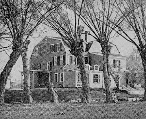
Home of Dorothy Quincy |
In
the basement beneath the church are the tombs of the two
Presidents and their wives in granite sarcophagi. Application to
the sexton and the payment of a modest fee prescribed by the church
enables the visitor to descend into the electrically lighted vault
and, through a doorway protected by a grille, to gaze upon the tombs.
On either side of the doorway are inscriptions on marble tablets.
The
body of the ancient black hearse in which the remains of the
Presidents were conveyed is also preserved in this basement in a
glass case.
Across
the way from the church is the granite City Hall, and close by
is the old burying ground where are the graves of the early
ministers of the parish, among them John Hancock, father of the
famous “signer” and governor; the tombs of Dr. Leonard Hoar,
third president of Harvard College, and his wife and mother; of Henry
Adams, immigrant ancestor of the Adams family; of John Quincy Adams,
in which his body was placed before removal to the church opposite;
of the first of the Quincys — Edmond; and of Josiah Quincy, Jr.,
who at thirty-one years of age died, in 1775, on the ship which was
bringing him back from his mission to England in behalf of the
patriots.
Near
by, on Washington Street, is the fine Crane Public Library,
and not far away, on Hancock Street, the Adams Academy,
founded by a gift to the town in 1822 by President John Adams, and
opened in 1872 — a classical school of high order. On Adams
Street, which diverges to the west and continues through to West
Quincy and Milton, stands the famous Adams mansion, originally
the country seat of Leonard Vassall, a West Indian planter and a
royalist like all of his name. Sequestered in the Revolution, it
became the home of President John Adams from 1787 till his death. In
it were celebrated his golden wedding and the weddings of his son,
President John Quincy Adams, and of his grand son, Charles Francis
Adams, Sr., once minister to Great Britain. It is now occupied by the
great-grandson, Brooks Adams, and much of the interior finish and
furniture is retained.
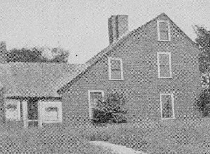
Birthplace of John Adams |
On
Hancock Street, facing Bridge Street, is
the old Quincy
mansion house, containing some part of the original dwelling of
Edmond Quincy, built about 1634, and dating itself from 1705. Here
was born Dorothy Quincy, the original of Dr. Holmes’s poem,
“Dorothy Q.,” whose granddaughter was the poet’s mother.
Another Dorothy Quincy, descendant of the first, was the wife of John
Hancock.
From
the square, in a southeastern direction, we walk or take a
Brockton car past the old burial ground of Christ Church, Braintree
(the present city of Quincy was part of Braintree from 1640 to 1792),
in whose grass-grown mounds repose many of the early settlers.
|
At
the corner of Independence Street and Franklin Avenue
the car passes two time-stained houses standing close together,
restored and maintained as sacred memorials, to which the attention
of more visitors is turned than to any other buildings in Quincy. The
older and smaller house is the birthplace of John Adams. The
other and larger house, with the old well sweep in the back yard, is
the birthplace of John Quincy Adams. It was presented by the
present Charles Francis Adams to the Quincy Historical Society, which
has restored it to its original condition and made it a museum of
historic relics.
Much
of the early history of the Massachusetts Bay Colony is related to
this old town, notably Mount Wollaston, the high ground at the next
station on the way into Boston. It was the “Merrymount” of Thomas
Morton, whose revels with his crew of graceless roysterers and his
may pole, set up in 1627, caused his banishment by the stem Puritan
elders. The zealous antiquarian might spend days in tracing out the
historic sites and in viewing the historic mansions of Quincy.
DEDHAM
Dedham
is one of the oldest of the suburban towns, and was at first one of
the most extensive. Its territory, allotted by the General Court in
1635 to twenty-two proprietors, who had moved hither from Water town
and Roxbury a few months before, embraced nearly all of the present
Norfolk County. In August they had signed a “town covenant”
binding them to “walk in a peaceful conversation” and to
establish “a loving and comfortable society.” The name they
proposed for their settlement was Contentment. The General Court,
however, overruled their choice and gave the new parish the title of
Dedham from the English town whence several of the settlers had come.
It is a quiet, dignified old town, with majestic trees shading its
streets, many old mansions, and picturesque river views. The Charles
River, with its “Great Bend,” encircles the northern end of
the town, and the Neponset River is on its eastern border. The
two streams are connected by “Mother Brook,” the oldest canal in
the country, dug by the enterprising colonists in 1639-1640. Several
lofty hills break the surface of the town, and there are beautiful
drives and trolley rides in several directions — notably to
Westwood (formerly West Dedham), three miles from the center. The
main street is High Street, running nearly east and west
through the village and then turning off sharply to the southwest on
its way to Westwood and Medway. Along this street are scattered most
of the historic monuments.
We
reach Dedham by train over the Providence Division, New York, New
Haven & Hartford Railroad (though we could go in an electric car
from Forest Hills), and alight at the stone station, with its
imposing clock tower, at the center of the village. One block away is
the granite Memorial Hall, serving the double purpose of a
town house and a monument to the soldiers of the town who served in
the Civil War. On the corner of Church Street, next above, is the
low-arched brick building of the Dedham Historical Society,
with an interesting collection of antiquities and documents. On the
right-hand side of High Street, a little farther on, is the old Dr.
Nathaniel Ames house, the home of the famous almanac maker from
1772 to his death, fifty years later. Just beyond stood till 1897 the
Fisher Ames house, the home of Nathaniel’s distinguished
brother. This is now removed to River Place, and with enlargements
and improvements has become the home of Frederick J. Stimson, author
and lawyer.
On
the next street at the right, Ames Street, is the site of the
old Woodward Tavern, dating from 1658, where met the Suffolk
Convention in 1774, which at its adjourned meeting in the Vose
mansion at Milton adopted the Suffolk Resolves. Just above Ames
Street on High Street is the mansion house built in 1795 by Judge
Samuel Haven, in front of which are several stately English elms
brought from England in 1762, still vigorous and full of foliage.
Opposite is the granite Court House, surmounted by a dome, for
Dedham is the shire town of Norfolk County. Next beyond the Court
House is the ancient Village Green, in the corner of which stands the
locally famous “Pitt’s Head,” or Pillar of Liberty, a
square granite pedestal about two feet high, which formerly was
surmounted by a tall wooden column and a bust of William Pitt. It was
erected July 22, 1767. A bronze tablet on its eastern face, placed in
1886, on the two hundred and fiftieth anniversary of the town, gives
its history.
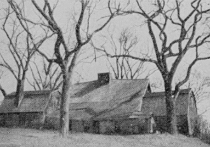
Old Fairbanks House |
At
the upper end of the Green stands the Unitarian Church, built in
1763, the third in succession from the original parish meetinghouse
built in 1638. Just across High Street is the First Congregational
Church, also ancient and, like the other, in the conventional Wren
style. Along both sides of the street for some distance are houses
mostly dating from the late eighteenth and early nineteenth
centuries, very comfortable looking, with their ample lawns shaded by
great elms.
Two
objects of special historic interest are easily reached by a short
walk from the center. Along Eastern Avenue, which runs south
from the railroad station and curves around through rows of water
willows to East Street, is the way to the Fairbanks house, one
of the oldest houses in the country. It was built about 1650 by
Jonathan Fairbanks, to whom the lands surrounding it were allotted in
1637. In 1896 it was purchased by Mrs. J. Amory Codman and daughter
of Boston, to save it from destruction. Previous to that time it had
always been owned by a Fairbanks. In 1903 the “Fairbanks Family in
America” being incorporated, acquired the property to be kept
permanently in the family as an historic home.
|
The
other historic relic, only a short distance from the Fairbanks house,
is the “Avery oak.” It is a great tree, older than the town, with
a circumference, five feet from the ground, of sixteen feet. Its
owner at the time is said to have refused seventy dollars for it from
the builders of the Constitution, who desired it for timber
for “Old Ironsides.” It is still sturdy and thrifty. It has been
secured for preservation by the Dedham Historical Society.
WINTHROP
AND REVERE
Winthrop
alone among the northern suburbs of Boston is without a trolley line,
and that it has none is due to the excellent service afforded by the
Winthrop circuit of the Boston, Revere Beach & Lynn Railroad. The
ferry house and station of this railroad are at Rowe’s Wharf,
directly opposite the elevated railway station of the same name. The
ferryboats leave every fifteen minutes daily, connecting with trains
at Jeffries Point, on the East Boston side of the harbor; and the
fare to any of the nine stations in Winthrop is but five cents. The
line makes a loop around the town, reaching every section of it, and
the trains alternate in direction.
Winthrop
is an ancient settlement but a comparatively modern town. For nearly
a century after the first settlement its territory belonged to
Boston, but in 1739 it became a part of Chelsea. In 1846 it was
joined to Revere (the Rumney Marsh of early days) to form the new
town of North Chelsea. It became an independent town six years later,
taking the name of Winthrop in commemoration of Deane Winthrop, sixth
son of Governor John Winthrop, who lived here for many years in a
house still preserved, and here died about 1703 or 1704, aged 81. The
first name of the hamlet was Pullen Poynt, but the year 1753 saw the
establishment of a codfishery station at the extreme eastern end, and
the “syndicate” which promoted that enterprise rechristened the
place Point Shirley, from the governor of the Province. The
fishery “trust” proved a failure, but Point Shirley was found to
be so pleasant that a number of Boston families built country houses
here, the Hancocks among the rest. A roomy brick house still standing
at this point of the town, which retains the name of Point Shirley,
is by some assumed to have been John Hancock’s house, but this is
doubtful. In later days the present Point Shirley became noted
through “Taft’s,” a hostelry famous for its fish and game
dinners, now only a memory. Until about 1876 Winthrop remained a
slumbrous farming town within five miles of the city across the
harbor but known only to the few. Then it was rediscovered, and the
building of the narrow, gauge railroad made it easy of access. With
the advent of this railroad a beach settlement was laid out, streets
with nautical names were cut through, and lots were sold off. A
colony of summer cottages sprang up in a season or two, and “Ocean
Spray” and “Cottage Hill” became familiar names. In course of
time substantial houses to a large extent replaced the shells first
erected; a beautiful, broad boulevard, with walks on each side, was
built by the Metropolitan Parks Commission along the ocean front
where had been a town way known as “The Crest” (destroyed by a
gale in November, 1898); and the old farms of the inland part of the
town became thickly covered with residences.
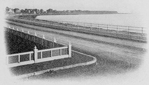
Winthrop Boulevard |
The
fine half-moon sweep of the Winthrop Beach, something more
than a half mile in length, is crowned at either end by a high bluff:
that to the seaward, the Great Head of old, now trivially
named “Cottage Hill”; and that at the northern end, Grover’s
Cliff, now occupied by Fort Heath, a strong work, mounting
several twelve-inch rifled guns, which was rushed to completion
during the Spanish war. Inland a little way is Fort Banks,
with its sixteen breech-loading mortars and an extensive group
of buildings, sufficient for a large army post.
On
the eastern side of Crystal Bay, which almost isolates the beach
section from the “old town,” is the Winthrop Yacht Clubhouse.
The railroad loop crosses this bay by a long bridge with a draw at
the channel. One may spend an afternoon pleasantly by taking a train
to Winthrop Center and walking over to the harbor side of the
town. Along Pleasant and Sargent streets and Court Park Road is
probably the most agreeable course, making the circuit of Court Park
(so named in honor of Judges George B. Loring and John Lowell, who
formerly owned the whole area now laid out in house lots), where are
the Winthrop Golf Club’s links, and continuing through
Pleasant Street along the harbor front to the station just beyond
Main Street, taking here a train to Winthrop Beach. From this point
Cottage Hill may be climbed for the view of the town, the bay, and
the harbor.
|
A
walk along Winthrop Beach naturally follows, with the surf
pounding on the right, and off beyond it the outer island, Nahant, to
the north, and the open sea in view, with a glimpse occasionally of a
steamer coming in. Near the upper end of the beach we should turn off
and pass through Neptune Avenue and Shirley Street (the latter the
old county road), by the Ocean Spray station of the railroad, to the
old Deane Winthrop house on the right, marked by a tablet. A
few steps farther to the intersection of Revere Street, and we are at
the entrance of Fort Banks, the saluting battery, the brick hospital,
and the command ant’s headquarters. We may follow Revere Street up
a moderate slope to Summit Avenue, and taking this street to the
right we shall get other fine views, while about us is picturesque
Winthrop Highlands, as this section of the town is
called. It
is but a few steps down the eastern end of Summit Avenue and along
Crest Avenue (to the left) to the Highlands station. Here we may take
the next Boston-bound train back to Orient Heights (as soon as
we cross Belle Isle inlet we are on Breed’s Island, the newer part
of East Boston), and at this station change to a train passing over
the main line for Crescent Beach at the lower end of the
famous Revere Beach. On the way we pass the station at
Beachmont at the foot of a fine hill thickly covered with
houses, the other side of which we have seen from Summit Avenue,
Winthrop Highlands.
At
Crescent Beach the railroad is but a few rods back from the great
beach boulevard of the Metropolitan Parks System, which
extends along the ocean front for two miles with its splendid roadway
and broad promenades on either side. The Revere Beach Reservation
embraces the whole length of the beach to the Point of Pines, at the
mouth of Saugus River. Near the middle of its length is an ornate
band stand, and near its northern end the great State Bath House
(the rail road has a station just at the rear of the Bath House). The
boys’ bath room will accommodate five hundred boys at a time. All
along the land side of the boulevard are various amusement places, —
the steeplechase, the roller coaster, electric boats on a small lake,
refreshment booths and restaurants, tintype galleries, and all the
paraphernalia of a modern seaside resort for the people. Back from
the shore, in easy connection with the Reservation, is the great show
place of “Wonderland.” Perfect order is preserved by the
Metropolitan Park police. On a warm afternoon and evening the
visitors are numbered by scores of thousands, and the driving along
the superb roadway makes an interesting pageant.
From
the southern end of the Reservation the Revere Beach Parkway
extends nearly five and a quarter miles west to the lower end
of
Med ford, where it joins the Fellsway, leading north to the
Middlesex Fells. The electric cars of the Boston &
Northern system run through the turfed center of this parkway till
the Revere station of the Boston & Maine Railroad is reached, and
there the Parkway crosses the tracks overhead. At the Revere station
they take a more direct route via Winthrop Avenue and Beech Street,
through Revere Center to Fenno’s Corner, whence they turn sharply
off to the left into Broadway and so through Chelsea into Boston.
Much
of the history of Revere has been identical with that of
Winthrop, as we have seen. Up to 1852, when the latter town set up
for itself, they had been associated municipally from the very first.
In 1871 the name of North Chelsea was changed to Revere. With the
exception of its beach section and the bold drumlin now covered by
the semi-summer-resort settlement of Beachmont, it is a quiet
town, still largely devoted to farming, with the scattered homes of
old families. On the way inward through Broadway, before we cross
Snake or Mill Creek, which lies partly in the Parkway, we may see off
to the left the old Yeaman house, built about 1680, a typical
farmhouse of the early days, with its gambrel roof and lean-to.
CHELSEA
When
we cross Snake Creek we are in Chelsea, which in 1634 was made
a part of Boston by one of those terse, phonetic orders of the
General Court, so much more definite than the long-drawn “acts”
of our modern legislatures, that “Wynetsemt shall belong to
Boston.”
Chelsea
has numerous attractive features. Within its limits is the fine
curving eminence of Powderhorn Hill, which we reach on our
right and may ascend by a direct avenue from Broadway. The spreading
building on its summit is the Massachusetts Soldiers’ Home,
originally erected for a summer hotel. From the pleasant lawn and
long shaded verandas of this institution, where the broken soldiers
of the Civil War sit and smoke their pipes through the long summer
afternoons, one may look far down the harbor and well-nigh all over
the city below. From the top of the old reservoir near by the view
takes in the Mystic marshes and the whole sweep of hills bounding the
Boston Basin.
To
the northwest of Powderhorn, and lying mostly in Everett, is Mount
Washington, reached by Washington Avenue, through which trolley
cars run, and to which we may cross through Summit and Winthrop
avenues at the west end of Powderhorn. Turning into Washington Avenue
to the right, a few steps bring us to Washington Park, maintained
by the Chelsea Park Commission. Set into the park wall is a large
flat stone bearing this legend: This stone, once a doorstep of the
old Pratt mansion visited by Washington during the siege of Boston,
stands opposite the barrack-grounds of Colonel Gerrish’s regiment
of 1775-76.
Another
landmark of earlier date is the Way-Ireland house, — in
later years the Pratt family homestead, — in which Increase Mather
was in hiding for a time before he sailed for England in April, 1688,
as agent for the colonists, to intercede with the king against the
oppressions of Andros. It stands near the foot of this hill, just off
Washington Avenue, which winds to the right and continues to Woodlawn
Cemetery.
Returning
by a Washington Avenue car down Broadway and, if we choose, into
Boston through the Charlestown District, we shall cross the Eastern
Division of the Boston & Maine just beside the Chelsea station.
Near by is Union Park, in which stands the Chelsea Soldiers’
Monument. At Bellingham Square, where we turn into Broadway, we take
a course directly southwest to the bridge over the Mystic into
Charlestown. As we near the bridge we see on our right the extensive
grounds occupied by the United States Naval Hospital and the
Marine Hospital, the former for sick and disabled officers
and
men of the navy, the latter for invalids of the merchant marine. The
grounds are sightly, sloping to the river and shaded by ancient
trees.
On
the farther end of the tract, where the Island End River joins the
Mystic River, is the site of Samuel Maverick’s fortified house,
built in 1624-1625. Maverick described it as having “a Pillizado
fflankers and gunnes both below and above in them which awed the
Indians,” and no wonder. It was here that Maverick entertained
Governor Winthrop and his associate leaders on their first coming in
1630. Maverick afterward removed to Noddle’s Island, now East
Boston.
SOMERVILLE,
MEDFORD, AND MALDEN
It
is a pleasant trip to Medford, by the way of Somerville,
with much historic interest. Taking an elevated train to the Sullivan
Square terminal, and there changing to a Highland Avenue car, a
fifteen minutes’ ride will bring us to Central Square, at the
eastern end of Prospect Hill. This hill is historic as the
site of the citadel, the most formidable works in the American lines
during the Siege of Boston, and as the place where the Union flag
with its thirteen stripes was first hoisted, January 1, 1776. These
facts are related upon a tablet which stands on the present top of
the hill, with the exception of one small point fifteen feet or so
lower now than at that time. On its long summit General Putnam made
his headquarters after the battle of Bunker Hill, and here also
during the winter of 1777-1778 were quartered the British troops
captured at Saratoga with Burgoyne. The point left uncut is now
reserved in a park, and an observatory is to be built on its summit.
Central
Hill beyond, over which our car soon passes, is also associated
with the Revolution. Its summit is an open, parklike space, at the
easterly end of which is observed a miniature redoubt with cannon
mounted. This is intended to mark the site of French’s Redoubt
thrown up after the battle of Bunker Hill, Which became a part of the
besieging lines of Boston.
In
this highland common are grouped a series of public buildings,
— the City Hall, the Public Library, the High School, and the
English High School.
On
Winter Hill, northward, stood another Continental fort,
and the chief one, connected with the Central Hill battery and the
citadel on Prospect Hill by a line of earthworks. Near the foot of
Central Hill, in a well-preserved old house marked by a tablet, are
seen the head quarters of General Charles Lee during the Siege. Over
on Spring Hill, to the west, Lord Percy’s artillery for a
time covered the retreat of his tired infantry on that memorable 19th
of April. On Willow Avenue near Davis Square, West Somerville, a
tablet records a sharp fight at this point, and marks graves of
British soldiers here.
At
Davis Square we leave the car and walk through Elm Street, which
curves to the right, to the junction of College Avenue, Broadway, and
Powderhouse Avenue. Here, in a little park, stands the picturesque as
well as historic Old Powder House, a tower with conical top,
thirty feet high and about twenty feet in diameter at the ground,
with thick walls of brick, and barred doorway and window.
It
was first a mill, built about 1703-1704, and became a Province powder
house in 1747. On September 1, 1774, General Gage seized the 25o
half-barrels of gun powder stored within it and thereby provoked the
great assembly of the following day on Cambridge Common. In 1775 it
became the magazine of the American army besieging Boston.
To
the northwest from this park it is but a few minutes’ walk through
College Avenue to the pleasant grounds of Tufts College, which
covers nearly all of College Hill and commands a wide and
charming prospect of the surrounding country. Just beyond the
railroad station (Southern Division, Boston & Maine) we enter
Professors Row, which follows the curve of the hill to the
left, and pass the houses of President Hamilton and others of the
faculty; also Metcalf Hall, a dormitory for women students. To
the right, on the crest of the hill, reached by a broad walk under
lofty elms, stand the chief buildings of the college: Ballou Hall,
the oldest; the noteworthy Goddard Chapel, of stone,
with
a hundred-foot campanile; the Barnum Museum of Natural History,
built and endowed by the famous showman and containing among other
things the skeleton of the great elephant Jumbo; the Goddard
Gymnasium; East and West Halls, dormitories; the Library
and the two Divinity School buildings, Miner Hall and Paige
Hall. On the other side of College Avenue, near the entrance by
which we came, are the Commons building, the Chemical Building,
and the Bromfield-Pearson School; these last two being part of
the technical school plant.
From
the college grounds it is a pleasant walk to Main Street, Medford,
through College Avenue and Stearns Street. On Main Street, between
George and Royall Streets, we come upon a most interesting relic of
Provincial days. This is the Royall mansion house, built by
Colonel Isaac Royall in 1738. An earlier house on its site, erected
before 1690 it is said, was utilized in its construction. A building
at one side was originally the slave quarters, the only structure of
its kind remaining in Massachusetts. In 1775 the mansion was the
headquarters of Stark’s division of the Continental army. It is now
occupied by the Sarah Bradlee Fulton Chapter, D. A. R., and is open
to visitors for a modest fee.
Another
relic of an earlier period cherished here is the Craddock house,
said to date from 1634, and so entitled to the distinction of being
the oldest existing house in the country. It stands some distance
down the Mystic River side, on Riverside Avenue, toward East Medford.
Opposite it, on ‘the other side of the river, — the Somerville
(Winter Hill) side, — lay Governor Winthrop’s Ten Hills Farm.
In
Medford Square electric cars can be taken for Malden, Melrose, and
Everett in one direction, and for Winchester, Woburn, and Lowell in
another. Forest Street is a Medford entrance to the Middlesex
Fells. Electric cars now run through Middlesex Fells, starting
from the Sullivan Square terminal of the Elevated system.
Across
to Malden is an agreeable ride. The route passes the Middle
sex Fells Parkway, a Malden entrance to the southeasterly section of
the Fells, the most romantic part of the Reservation. As it
nears the finish the parkway widens into Fellsmere, a small park. In
Malden Center is the Public Library and Art Gallery, noteworthy as
one of the best examples of the work of the architect, H. H.
Richardson, in public buildings.
WINCHESTER
Winchester,
which touches the western side of the Fells, is one of the
most picturesque towns of the metropolitan region. Its natural beauty
in wooded hill and vale, river and lake (the Mystic ponds), is
unusual, and this has been to a great extent worthily retained in the
building up of the town. It is next to Brookline, perhaps, in
richness of possessions and as a favored residential place for
substantial business and professional men of Boston. It has a few
large country seats, some old-time family mansions, and a great
variety of tasteful houses of modern build. It is connected with
Medford and Arlington by electric lines, and so with Boston; but the
more direct connection is by railroad (Boston & Maine, North
Station).
|


 Click the book image to turn
to the next Chapter.
Click the book image to turn
to the next Chapter.